Canyoneering Route Description
Teeny Tiny Loop - 4A II (III)
Ticaboo Mesa, Utah.
04-28-15, 2 people, 1 Day (Travel time in route 6.5 hours)
 Time includes long break overlooking Lake Powell.
Time Required - 4 to 6 hours
Distance - 4.7 miles Total, 0.3 miles Technical
Rappels - 3 Rappels, Longest Rappel 80 feet.
(2 Raps in Teeny to 50 feet and 1 rap in Tiny at 80 feet)
Elevation Range - 4900 - 4030 Feet
Shuttle Required - No Miles Vehicle - High Clearance, 4WD if bad road conditions
Permit Required - No
Rappelling and anchor gear, Ropes and or pull cords for rappels up
to 80 feet and 30 feet of 1 inch webbing in case you find a need.
Tiny Tiny Loop is a route on Ticaboo Mesa that will get you
off the beaten path, travel through two very short slots and offers a 0.8 mile
round trip side trip to an incredible view point overlooking Lake Powell. The
Tiny Tiny Loop is not a destination if you are looking for maximum canyon time
but is worth doing if you want a relaxed pace, good scenery and a touch of
canyon fun mixed in. The two short slots on the Teeny Tiny Loop are called
Teeny Canyon and Tiny Canyon.
Teeny Tiny Loop is an overall easy route but is rated
a 4 in technical difficulty due to the need of using a Sandtrap.
Potshots will likely never be needed but one should be on hand in the event
a couple of the potholes scour out making escapes difficult.
To get to the Trailhead
Note:
There is a maze of roads on Ticaboo Mesa making it a good idea
to study the map ahead of time and keep a close eye on the map
as you drive.
From Hanksville, UT., drive south on highway 95 for 26 miles to
the junction of highways 95 and 276.
From the junction, drive south on HWY-276 for 25.6 miles then
turn left (east) onto BLM dirt-road 13400 between mile markers
25 and 26 (extTicaboo1).
About 1.5 miles from the highway is a junction (TicabooDP-01)
of BLM roads, 13400 continues east and 13410 branches off to the
south. Continue east on BLM road 13400. Note: If you were headed
to the Smith Fork area you would turn south onto BLM road 13410.
About 2 miles farther is another junction
(TicabooDP-02) of BLM roads, 13400 continues east and 13420
branches off to the south. Continue east on BLM road 13400.
Note: BLM road 13420 to the south goes out to Cane Spring Well
about 1.25 miles south.
About 0.2 miles farther is short side road (TicabooDP-03) on the
left (north) that goes to a camp area.
Stay right to
continue on BLM road 13400. Beyond this point the roads
will have intermittent rough sections.
About 0.37
miles past here is a fork in the road where the two roads rejoin
a short distance later. The low road is typically the
smoothest.
About 1.7 miles farther is another junction (TicabooDP-04) of
BLM roads (13400 continues north-ish and 13430 branches off to
the south).
Continue north on BLM road 13400.
Note: If you were going to the roads between Warm Springs Creek
and Sevenmile Creek, you would turn south onto BLM road 13430.
About 0.3 miles farther is another junction (TicabooDP-05) of
BLM roads (13400 continues northeast and 13440 branches off to
the north).
Continue straight northeast on BLM road 13400.
Note: BLM road 13440 to the south goes out to Colt Spring Well
about 0.4 miles north.
About 0.5 miles farther is a junction (TicabooDP-06) of BLM
roads (13400 continues northeast and 13450 branches off to the
north).
Continue straight northeast on BLM road 13400.
About 0.9 miles farther is a junction (TicabooDP-07) of BLM
roads (13400 continues northeast and 13430 branches off to the
south).
Turn south onto BLM road 13430.
Note: If you were
going to Tough, SF Ticaboo or Sleepytime Trio Canyons you would
continue northeast on BLM road 13400.
About 700 feet farther is a fork in the road (extWarmSpring).
At this fork stay left to continue toward the East Branch of
Seven Mile Creek.
About 0.4 miles farther is another fork in the road
(ext7MileCkEB). Veer right (more south) to continue toward
the East Branch of 7 Mile Creek.
About 1.0 mile farther is a junction (7MileCkEBDP-01) where a
side road joins in from the left. Continue straight
(south) past the side road.
About 0.5 miles farther is a jog in the road (7MileCkEBDP-02)
near an old stock pond. Veer left to continue south.
About 1.1 miles farther will be a wide pull out on the left side
of the road (pkHardDayHarvy). Continue past this turnout
as the road winds and begins to travel more east.
About 0.8 miles past the turnout is road junction (pkEuphrates).
Park near this junction where you can get off the road.
Note:
Continuing left (north) at this junction goes over toward
FiddleStix and to the right is a short spur road to a wide area
to park.
To leave the Exit Vehicle / Escape Pod
No exit vehicle is needed. This is done as a loop route.
GPS coordinate information listed at the bottom. For information about waypoint naming and map symbols, refer to the
Glossary page.

Click the links for maps of the route.
Map of the drive into the route.
Map of the entire route.
Map of the Teeny Tiny Loop and the side trip to a Lake Powell Over look.
Zoomed in map of the Teeny and Tiny Canyons.
The Approach:
From the parking spot (pkEuphrates)
walk southwest about 250
feet to where you can
start dropping
(wEuphrateRP-01) down
from the level you
parked on. Work
your way down the slope
to the next level then
continue walking
southwest to the top of
a rubble pile
(wEuphrateRP-02) then
route find your way to
the bottom of the rubble
hill.
From the bottom of the
rubble hill turn left
(east) and walk along
the top of the slick
rock just below the dirt
for about 0.2 miles
until you are just under
a point (TeenyTiny01).
From that point
(TeenyTiny01) continue
walking northeast just
under the base of the
cliff band for about
1100 feet over to under
the next point on the
mesa. Staying high and
following just below the
dirt makes for the
easiest travel.
From that next point
(TeenyTiny02) walk south
east down the slope away
from the cliff band. As
you walk follow down the
slope next to a shallow
drainage with a little
vegetation. The goal is
to get to a small valley
about 0.32 miles away
that can almost be seen
from the point.
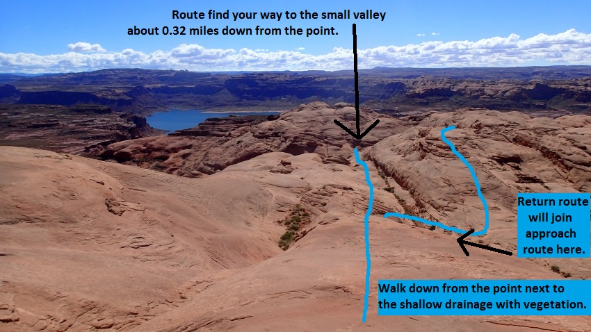 Walk down the slickrock and find your way to a small valley about 0.32 miles
away.
Walk down the slickrock and find your way to a small valley about 0.32 miles
away.
When you get to the
small valley
(TeenyTiny03) veer right
(south) and walk up a
short sandy drainage
that turns to slickrock
about 180 feet away.
Note:
There are a couple short
but steep dropping slots
to the north of here but
neither seemed to elicit
a desire to go down them
when we looked at them.
After about 200 feet the
small drainage turns
from sand to going up
slickrock (TeenyTiny04).
Continue south up the
slickrock with a 4 foot
and a 6 foot upclimb
(both easy) along the
way. The drainage will
slowly veer left to
travel more south east
and finally top out on a
small saddle a little
over 500 feet up from
the small valley.
From the small saddle
(TeenyTiny05) continue
down the drainage to the
south east about 200
feet to where it opens
up to another wide open
sandy area.
When it opens up
(TeenyTiny06) turn right
and walk up the slick
rock to another small
saddle about 250 feet
away.
Note:
For an alternate choice
with a scenic treat walk
across the open sandy
area about 650 feet to
get a great view over
toward Lake Powell. If
you choose to do this
you can just walk south
around the hill to meet
up with the route you
would have used if going
up over the saddle.
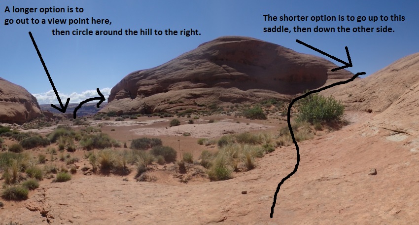
From the small saddle
(TeenyTiny07) walk and
scramble your way south
down the slickrock then
into a dirt area and
over to the head of a
large drainage about 300
feet away.
When you get to the head
of the large drainage
you are at the top of
Teeny Canyon (yTeenyTp).
Bypass this upper
portion of Teeny canyon
by walking right (west)
to a ledge to walk
around this upper
section and drop into
Teeny Canyon a little
farther down.
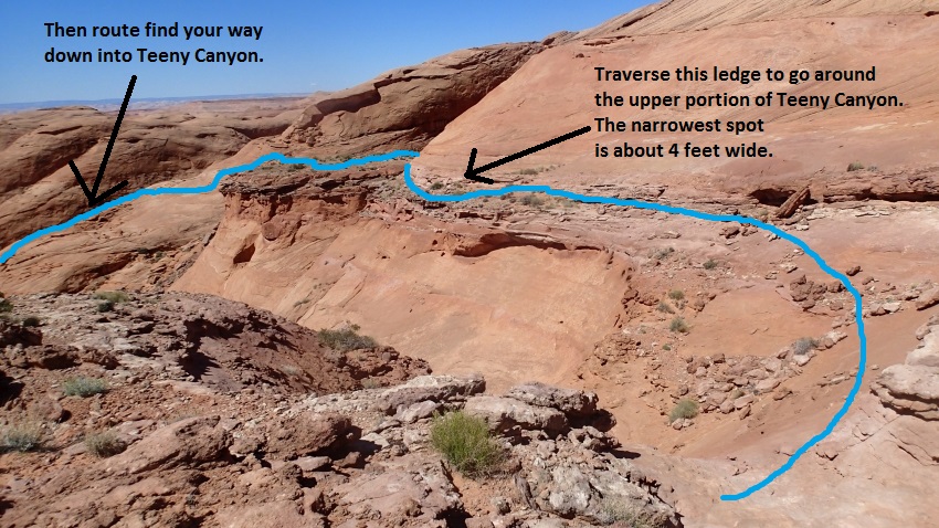
The narrowest spot
(TeenyTiny08) on the
ledge 400 foot long
ledge is about 4 feet
wide. The ledge
traverses from the head
of Teeny Canyon over to
a wide flat dirt area.
When you get to the wide
dirt area, walk
southwest about 100 feet
to the other end where
you can then scramble
down.
From the southwest end
of a wide sandy area
(TeenyTiny09) after
traversing along a
ledge. Scramble south
down loose rock and dirt
down about 100 feet to
slickrock below. Once
down to the slickrock
level route find your
way south along the
slickrock around a point
into a small side
drainage which can be
used to get down into
Teeny Canyon.
From the small side
drainage (TeenyTiny10)
scramble down the small
drainage / runnel here
to the floor of the
canyon.
The Canyoneering / Technical Section
- Teeny Canyon:
When you get down
to the canyon floor
(TeenyTiny11) turn right
to walk south about 40
feet to rap 1.
Rap 1 (dTeenyR1-2) is
anchored from a small
bush about 30 feet back
and drops about 25 feet
down a vertical drop to
a sandy floor.
Rap 2 about 60 feet down
canyon of rap 1 is
anchored using a
sandtrap and drops about
50 feet to a very large
sand filled pothole. A
little over 100 feet
after rap 2 is the start
of a narrow slot.
Shortly into the slot is
an easy stem style
downclimb (TeenyTiny12)
of about 15 feet down
into a corridor a little
over 200 feet long.
About 300 feet down
canyon is an easy
downclimb of about 20
feet (TeenyTiny13) then
continue into more open
corridor.
About 200 feet down
canyon is a downclimb of
about 15 feet
(TeenyTiny14) into
another crack then
another downclimb of
about 15 feet again.
From here walk about 350
feet to where the
drainage turns right
(south) and a small side
drainage joins in from
the left (yTeenyBt).
After Teeny
Canyon - Choose Side
Trip or Continue to Tiny
Canyon:
From the bottom of
Teeny Canyon where the
small side drainage
joins in from the left (yTeenyBt)
you can take a side trip
out to a great scenic
overlook with good views
of Lake Powell or
continue over to Tiny
Canyon.
To go out to a
great view point over
Lake Powel......
The
side trip is about 0.8
miles round trip south.
Walk south down the
drainage about 500 feet
to a shelf (TeenyView01)
in the wash of about 20
feet that is easily
bypassed on either side.
Continue down the
drainage another 750
feet to a huge drop /
shelf (TeenyView02) in
the wash. Leave the
drainage at the huge
drop and route find your
way southeast about 700
feet to the top of the
cliff looking down over
Lake Powell (sTeenyView).
If you like seeing the
survey markers in an
area there is a survey
marker (Teeny-BM) near
here if you look around.
After enjoying the views
and or a lunch break
walk back to the bottom
of Teeny Canyon to
continue the route.
Approach to Tiny
Canyon from the bottom
of Teeny Canyon:
From the bottom of
Teeny Canyon (yTeenyBt)
start scrambling west up
the base of the
sandstone point on the
RDC side and route find
your way up the
slickrock roughly
paralleling back up
Teeny Canyon on its RDC
side.
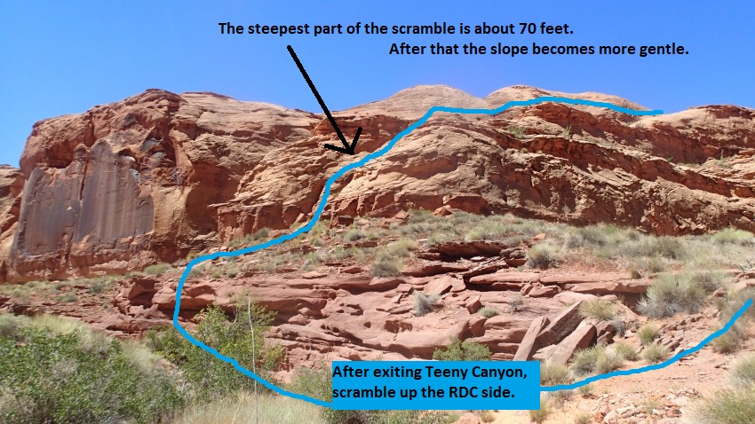
From the base of the
cliff (TeenyTiny15) it
is steep for about 70
feet then the slope gets
much more gentle. As you
continue up stay as far
left / up as possible
and work your way up to
the west about 500 feet
to where you have good
views down over toward
the top portion of Teeny
Canyon you bypassed on
the approach.
From where you can see
down toward the upper
portion of Teeny Canyon
to the north and are
almost topped out on a
slickrock hill
(TeenyTiny16) continue
to Tiny Canyon by
turning left and walk
south about 100 feet to
a shallow saddle.
Note:
If you want to exit
without doing Tiny
Canyon you can route
find your way down to
the the approach route
above Teeny Canyon and
reverse the approach
route to
exit.
From the shallow saddle
(TeenyTiny17) travel
south down slickrock to
a sandy area about 350
feet away. Then
walk across the sandy
area to the start of a
slot (yTinyTp) which is
the top of Tiny Canyon.
The Canyoneering / Technical Section
- Tiny Canyon:
From top of Tiny
Canyon (yTinyTp) the
first part of the slot
is a narrow walk through
for about 100 feet to a
downclimb.
The downclimb
(TeenyTiny18) is a stem
style downclimb of about
12 feet followed by a
more difficult downclimb
of about 10 feet that
may require a partner
assist for some. At the
bottom of the 10 foot
downclimb is a sand
filled pothole to cross
that would be easy to
exit if scoured out. On
the other side of the
pothole is a drop down
into another pothole
with rap 1 on the other
side of the pothole.
Note:
The drop into this third
sand filled pothole when
we visited in April of
2015 was about 6 feet
with a vertical exit on
the other side. At the
sand level we had it was
an easy climb out of the
pothole but if sand
scours out of this
pothole it will be
difficult to exit and a
potshot may be needed.
Rap 1 (dTinyR1) is
anchored using a
sandtrap in a pothole
and uses about 80 feet
to go over two drops
with a pothole part way
down.
After rap 1 are two
potholes to cross that
may require partner
assist or potshots to
get out of if sand is
scoured out. The second
pothole taller people
can bridge over. A short
section of open V slot
followed by a left hand
bend in the canyon gets
you out into an open
sandy area at the end of
the canyon (yTinyBt).
The Exit:
From the
bottom of Tiny Canyon (yTinyBt)
turn immediately right
and start west then
north up the steep
slickrock roughly
paralleling Tiny Canyon.
The first 130 feet up
the slickrock is kind of
steep and has loose rock
and debris and care
should be taken.
From where the scramble
up becomes less steep
(TeenyTiny19) continue
up the less steep slick
rock for about 240 feet
to the top out.
From the top out
(TeenyTiny20) route find
your way down to the
north about 400 feet to
another wide sandy area.
From the wide sandy area
(TeenyTiny21) continue
north across the sandy
spot to a fork then
continue north up the
right fork. Route find
your way about 500 feet
to where you are once
again on the rim of
Teeny Canyon where the
approach route started
dropping into the
canyon.
Note:
If you turn and walk
southeast down this
sandy area you will go
back to the top of Tiny
Canyon. Good to
know if you want to do
laps on it.
When you re-connect with
the approach route and
are just above the entry
point into Teeny Canyon
(TeenyTiny10) stay high
and turn left
(northwest) and route
find your way back up to
the rim, traverse the
ledge to get back to the
top of upper Teeny
Canyon (yTeenyTp).
From the top of Teeny
Canyon (yTeenyTp) go
north up to the small
saddle (TeenyTiny07)
then down the other side
to the bottom of the
small drainage
(TeenyTiny06) then up
the drainage to the
other saddle
(TeenyTiny05).
From the saddle
(TeenyTiny05) you can
drop back down to the
small valley used during
the approach and reverse
the approach route back
to the car or you can
use an alternate route
and not go through the
small valley.
To use the alternate
route travel down from
the saddle about 200
feet then veer left and
continue up the drainage
to the northwest
(TeenyTiny22).
Then route find up the
slickrock and continue
northwest to intersect
with the approach route
again. About 0.3
miles up the slickrock
is a saddle
(TeenyTiny23) where you
then drop down to the
right (northeast) to
meet up with the
approach route again
then continue reversing
the approach route back
to the car.
Downloadable GPX files
available at
BG-Gear Store
(easier than manual entry and a great way to support
Bluugnome).
Waypoint naming convention and map symbol information can be found on the Glossary page.
Elevations are approximate.
BEFORE
manually entering coordinates set your system to WGS84 datum and Lat/Lon hddd.ddddd° coordinate format.
Inconsistent datum's and coordinate formats will result in location errors.
Click to show / expand the list of waypoints below........
| Teeny Tiny Loop (1) - Drive in to Trailhead |
- extTicaboo1
Lat/Lon (WGS84): N 37.69720
W -110.67138
Elev: 4,520 Feet
Exit off of highway 276 to get to the Ticaboo Mesa area. Turn east and leave the highway on a dirt road. Near Mile post 25.
- TicabooDP-01
Lat/Lon (WGS84): N 37.68607
W -110.65188
Elev: NaN Feet
Continue straight for the main area of Ticaboo Mesa. Or Turn right (south) here for an alternate route over toward the Smith Fork Canyons.
- TicabooDP-02
Lat/Lon (WGS84): N 37.67981
W -110.62886
Elev: NaN Feet
Road junction with faint road running to the south. Continue straight (east).
Road to the south is about 1.25 miles long and goes down toward Cane Spring Well.
- TicabooDP-03
Lat/Lon (WGS84): N 37.68038
W -110.62628
Elev: 4,565 Feet
Exit to a spot to camp if the roads ahead are too rough.
- TicabooDP-04
Lat/Lon (WGS84): N 37.67963
W -110.60429
Elev: NaN Feet
Junction for a road going south. Continue straiaght (north east) to continue toward Ticaboo Measa. This road junction is near Wild Horse Springs.
- TicabooDP-05
Lat/Lon (WGS84): N 37.68389
W -110.60153
Elev: NaN Feet
Junction for a side road on the left going north. Continue north east toward Ticaboo Mesa.
The road going north is BLM Road 13440 aobut 0.4 miles long and goes over toward Colt Spring.
- TicabooDP-06
Lat/Lon (WGS84): N 37.68667
W -110.59547
Elev: NaN Feet
Junction for a side road going north.
The Road north is BLM Road 13540 and goes out toward Upper South Fork Ticaboo.
- TicabooDP-07
Lat/Lon (WGS84): N 37.69529
W -110.58385
Elev: NaN Feet
Turn off for a side road on the right. Turn right onto the side road and drive southwest.
- extWarmSpring
Lat/Lon (WGS84): N 37.69362
W -110.58484
Elev: NaN Feet
Stay right to go toward the main drainage of Seven Mile Creek and Warm Springs Canyon. Or Stay left to go toward the East Branch of Seven Mile Creek and Ticaboo Mesa.
- ext7MileCkEB
Lat/Lon (WGS84): N 37.69147
W -110.58014
Elev: NaN Feet
Turn right (more south) to continue toward the East Branch of Seven Mile Creek. Or veer left to continue toward Ticaboo Mesa.
- 7MileCkEBDP-01
Lat/Lon (WGS84): N 37.68044
W -110.56997
Elev: NaN Feet
Continuestraight (south) past a side road joining from the left. This road is not shown on all maps.
- 7MileCkEBDP-02
Lat/Lon (WGS84): N 37.67443
W -110.56735
Elev: NaN Feet
Jog in the road near a stock pond. Veer right and continue south. Turning left leads to a berm with a survey marker on it.
- pkHardDayHarvy
Lat/Lon (WGS84): N 37.66329
W -110.55625
Elev: 4,855 Feet
Park here for Hard Day Harvey. Hard Day Harvey is the East Fork of the East Branch of Seven Mile Creek.
- pkEuphrates
Lat/Lon (WGS84): N 37.66296
W -110.54411
Elev: 4,900 Feet
Park hear at a tee in the road to begin the route over to Euphrates.
|
| Teeny Tiny Loop (2) - Approach to Teeny Canyon |
- pkEuphrates
Lat/Lon (WGS84): N 37.66296
W -110.54411
Elev: 4,900 Feet
Park hear at a tee in the road to begin the route over to Euphrates.
- wEuphrateRP-01
Lat/Lon (WGS84): N 37.66247
W -110.54494
Elev: NaN Feet
Point to start dropping down from the level you parked on.
- wEuphrateRP-02
Lat/Lon (WGS84): N 37.66066
W -110.54656
Elev: 4,840 Feet
Top of a rubble pile allowing a way up or down from the rim here.
If exiting up go up the rubble pile then veer right (northeast) and route find your way back to teh Euphrates parking spot.
If going down to Tripoli drop down the hill then turn right (southwest) and walk along the base of the cliff band.
If going down to Euphrates drop down the hill then continue down to the head of Euphrates below.
If going down to the Teeny Tiny Loop drop down the hill then turn left (east) and walk along the top of the slick rock just below the dirt.
- TeenyTiny01
Lat/Lon (WGS84): N 37.66028
W -110.54292
Elev: NaN Feet
Go around the point here and continue walking northeast just under the base of the cliff band for about 1100 feet over to under the next point on the mesa. Staying high and following just below the dirt makes for the easiest travel.
- TeenyTiny02
Lat/Lon (WGS84): N 37.66207
W -110.54023
Elev: NaN Feet
Route goes under the next point on the mesa. To continue to the Teeny Tiny Loop, walk south east down the slope away from the cliff band. As you walk follow down the slope next to a shallow drainage with a little vegetation. The goal is to get to a small valley about 0.32 miles away that can almost be seen from the point.
- TeenyTiny03
Lat/Lon (WGS84): N 37.65986
W -110.53482
Elev: NaN Feet
Small valley. To continue on the Teeny Tiny Loop veer right (south) and walk up a short sandy drainage that turns to slickrock about 180 feet away.
Note:
There are a couple short but steep dropping slots to the north of here but neither seemed to elicit a desire to go down them when we looked at them.
- TeenyTiny04
Lat/Lon (WGS84): N 37.65941
W -110.53455
Elev: NaN Feet
Small drainage turns from sand to going up slickrock. Continue south up the slickrock with a 4 foot and a 6 foot upclimb (both easy) along the way. The drainage will slowly veer left to travel more south east and finally top out on a small saddle a little over 500 feet up from the small valley.
- TeenyTiny05
Lat/Lon (WGS84): N 37.65832
W -110.53386
Elev: NaN Feet
Saddle with drainages running down both sides. To continue on the Teeny Tiny Loop continue down the drainage to the south east about 200 feet to where it opens up to another wide open sandy area.
During the exit continue down the drainage to the northwest. Instead of going all the way back down to the sandy valley used on the approach, you can optionally veer left and travel northwest up a minor drainage then route find your way up along rolling slickrock.
- TeenyTiny06
Lat/Lon (WGS84): N 37.65803
W -110.53314
Elev: 4,540 Feet
Bottom of a small drainage down from a saddle and where it opens up to a wide open sandy area. To continue on the Teeny Tiny Loop turn right and walk up the slick rock to another small saddle about 250 feet away.
Note:
For an alternate choice with a scenic treat walk across the open sandy area about 650 feet to get a great view over toward Lake Powell. If you choose to do this you can just walk south around the hill to meet up with the route you would have used if going up over the saddle.
- sTinyView
Lat/Lon (WGS84): N 37.65703
W -110.53110
Elev: NaN Feet
Awesome view from the top of a cliff here. To meet up with the Teeny Tiny Loop route again travel southwest around the hill then north.
- TeenyTiny07
Lat/Lon (WGS84): N 37.65731
W -110.53333
Elev: NaN Feet
Small saddle. Walk and scramble your way south down the slickrock then into a dirt area and over to the head of a large drainage about 300 feet away.
- yTeenyTp
Lat/Lon (WGS84): N 37.65658
W -110.53356
Elev: 4,430 Feet
Top of Teeny Canyon which drops steeply down to the south. Bypass this upper portion of Teeny Canyon by walking right (west) to a ledge to walk around this upper section and drop into Teeny Canyon a little farther down.
|
| Teeny Tiny Loop (3) - Teeny Canyon |
- yTeenyTp
Lat/Lon (WGS84): N 37.65658
W -110.53356
Elev: 4,430 Feet
Top of Teeny Canyon which drops steeply down to the south. Bypass this upper portion of Teeny Canyon by walking right (west) to a ledge to walk around this upper section and drop into Teeny Canyon a little farther down.
- TeenyTiny08
Lat/Lon (WGS84): N 37.65632
W -110.53433
Elev: NaN Feet
The narrowest spot (TeenyTiny08) on the ledge 400 foot long ledge is about 4 feet wide. The ledge traverses from the head of Teeny Canyon over to a wide flat dirt area. When you get to the wide dirt area, walk southwest about 100 feet to the other end where you can then scramble down.
- TeenyTiny09
Lat/Lon (WGS84): N 37.65605
W -110.53482
Elev: NaN Feet
Southwest end of a wide sandy area after traversing along a ledge. Scramble south down loose rock and dirt down about 100 feet to slickrock below. Once down to the slickrock level route find your way south along the slickrock around a point into a small side drainage which can be used to get down into Teeny Canyon.
- TeenyTiny10
Lat/Lon (WGS84): N 37.65534
W -110.53420
Elev: 4,290 Feet
On the route into Teeny Canyon scramble down the small runnel here to the floor of the canyon.
On the exit from Tiny Canyon stay high and turn left (northwest) and route find your way back up to the rim where the approach route traversed the ledge by upper Teeny Canyon. From there reverse the approach route back to the car.
- TeenyTiny11
Lat/Lon (WGS84): N 37.65546
W -110.53387
Elev: NaN Feet
Down in Teeny Canyon. Turn right to walk south about 40 feet to rap 1.
- dTeenyR1-2
Lat/Lon (WGS84): N 37.65537
W -110.53380
Elev: 4,270 Feet
Raps 1 and 2 - Teeny Canyon.
Rap 1 is anchored from a small bush about 30 feet back and drops about 25 feet down a vertical drop to a sandy floor.
Rap 2 about 60 feet down canyon of rap 1 is anchored using a sandtrap and drops about 50 feet to a very large sand filled pothole. A little over 100 feet after rap 2 is the start of a narrow slot.
- TeenyTiny12
Lat/Lon (WGS84): N 37.65496
W -110.53330
Elev: NaN Feet
Easy stem style downclimb of about 15 feet down into a corridor a little over 200 feet long.
- TeenyTiny13
Lat/Lon (WGS84): N 37.65456
W -110.53234
Elev: NaN Feet
Easy downclimb of about 20 feet then continue into more open corridor.
- TeenyTiny14
Lat/Lon (WGS84): N 37.65438
W -110.53166
Elev: NaN Feet
Downclimb of about 15 feet into another crack then another downclimb of about 15 feet again. From here walk about 350 feet to where the drainage turns right (south) and a small side drainage joins in from the left.
- yTeenyBt
Lat/Lon (WGS84): N 37.65426
W -110.53055
Elev: 4,116 Feet
Bottom of Teeny Canyon.
To go out to a great view point over Lake Powel you can take a side trip about 0.8 miles round trip south down the drainage.
To Exit the area and or go over to Tiny Canyon start scrambling west up the base of the sandstone point on the RDC side and route find your way up the slickrock roughly paralleling back up Teeny Canyon on its RDC side.
|
| Teeny Tiny Loop (4) - Side Trip to Lake Powel View |
- yTeenyBt
Lat/Lon (WGS84): N 37.65426
W -110.53055
Elev: 4,116 Feet
Bottom of Teeny Canyon.
To go out to a great view point over Lake Powel you can take a side trip about 0.8 miles round trip south down the drainage.
To Exit the area and or go over to Tiny Canyon start scrambling west up the base of the sandstone point on the RDC side and route find your way up the slickrock roughly paralleling back up Teeny Canyon on its RDC side.
- TeenyView01
Lat/Lon (WGS84): N 37.65292
W -110.53041
Elev: NaN Feet
Shelf in the wash of about 20 feet that is easily bypassed on either side.
- TeenyView02
Lat/Lon (WGS84): N 37.65094
W -110.53015
Elev: NaN Feet
Huge drop / shelf in the wash. Leave the drainage here and route find your way southeast about 700 feet to the top of the cliff looking down over Lake Powell.
- Teeny-BM
Lat/Lon (WGS84): N 37.65004
W -110.52879
Elev: NaN Feet
Bench mark near teh scenic overlook on the Teeny Tiny Loop.
- sTeenyView
Lat/Lon (WGS84): N 37.64974
W -110.52830
Elev: 4,030 Feet
Awesome views out over Lake Powell and makes for a gret side trip / lunch break.
|
| Teeny Tiny Loop (5) - From Bottom of Teeny Canyon to and thru Tiny Canyon |
- yTeenyBt
Lat/Lon (WGS84): N 37.65426
W -110.53055
Elev: 4,116 Feet
Bottom of Teeny Canyon.
To go out to a great view point over Lake Powel you can take a side trip about 0.8 miles round trip south down the drainage.
To Exit the area and or go over to Tiny Canyon start scrambling west up the base of the sandstone point on the RDC side and route find your way up the slickrock roughly paralleling back up Teeny Canyon on its RDC side.
- TeenyTiny15
Lat/Lon (WGS84): N 37.65397
W -110.53087
Elev: NaN Feet
After exiting Teeny Canyon start scrambling up the base of the sandstone point on the RDC side. It is steep for about 70 feet then the slope gets much more gentle. As you continue up stay as far left / up as possible and work your way up to the west about 500 feet to where you have good views down over toward the top portion of Teeny Canyon you bypassed on the approach.
- TeenyTiny16
Lat/Lon (WGS84): N 37.65433
W -110.53285
Elev: NaN Feet
From here you can see down toward the upper portion of Teeny Canyon to the north and are almost topped out on a slickrock hill. To continue to Tiny Canyon turn left and walk south about 100 feet to a shallow saddle.
Note:
If you want to exit without doing Tiny Canyon you can route find your way down to the the approach route above Teeny Canyon and reverse the approach to exit.
- TeenyTiny17
Lat/Lon (WGS84): N 37.65405
W -110.53277
Elev: 4,296 Feet
Shallow slickrock saddle. To get to Tiny Canyon travel south down slickrock to a sandy area about 350 feet away.
- yTinyTp
Lat/Lon (WGS84): N 37.65296
W -110.53316
Elev: 4,240 Feet
Top of Tiny Canyon at the south end of a sandy area. The first part of the slot is a narrow walk through for about 100 feet to a downclimb.
- TeenyTiny18
Lat/Lon (WGS84): N 37.65268
W -110.53318
Elev: NaN Feet
Stem style downclimb of about 12 feet followed by a more difficult downclimb of about 10 feet that may require a partner assist for some. At the bottom of the 10 foot downclimb is a sand filled pothole to cross that would be easy to exit if scoured out. On the other side of the pothole is a drop down into another pothole with rap 1 on the other side of the pothole.
Note:
The drop into this third sand filled pothole when we visited in April of 2015 was about 6 feet with a vertical exit on the other side. At the sand level we had it was an easy climb out of the pothole but if sand scours out of this pothole it will be difficult to exit and a potshot may be needed.
- dTinyR1
Lat/Lon (WGS84): N 37.65249
W -110.53318
Elev: NaN Feet
Rap 1 - Tiny Canyon. Anchored using a sandtrap in a pothole and uses about 80 feet to go over two drops with a pothole part way down.
After rap 1 are two potholes to cross that may require partner assist or potshots to get out of if sand is scoured out. The second pothole taller people can bridge over. A short section of open V slot followed by a left hand bend in the canyon gets you out into an open sandy area at the end of the canyon.
- yTinyBt
Lat/Lon (WGS84): N 37.65205
W -110.53331
Elev: 4,210 Feet
Bottom of Tiny Canyon where it dumps out to a wide sandy area. To exit turn immediately right and start west then north up the steep slickrock roughly paralleling Tiny Canyon. The first 130 feet up the slickrock is kind of steep and has loose rock and debris and care should be taken.
|
| Teeny Tiny Loop (6) - Exit from Tiny Canyon |
- yTinyBt
Lat/Lon (WGS84): N 37.65205
W -110.53331
Elev: 4,210 Feet
Bottom of Tiny Canyon where it dumps out to a wide sandy area. To exit turn immediately right and start west then north up the steep slickrock roughly paralleling Tiny Canyon. The first 130 feet up the slickrock is kind of steep and has loose rock and debris and care should be taken.
- TeenyTiny19
Lat/Lon (WGS84): N 37.65230
W -110.53369
Elev: NaN Feet
Scramble up becomes less steep. Continue up the less steep slick rock for about 240 feet to the top out.
- TeenyTiny20
Lat/Lon (WGS84): N 37.65290
W -110.53391
Elev: NaN Feet
Top out of the slickrock. From here route find your way down to the north about 400 feet to another wide sandy area.
- TeenyTiny21
Lat/Lon (WGS84): N 37.65391
W -110.53386
Elev: NaN Feet
Wide sandy area. Continue north across the sandy spot to a fork then continue north up the right fork. Route find your way about 500 feet to where you are once again on the rim of Teeny Canyon where the approach route started dropping into the canyon.
Note:
If you turn and walk southeast down this sandy area you will go back to the top of Tiny Canyon. Good to know if you want to do laps on it.
- TeenyTiny10
Lat/Lon (WGS84): N 37.65534
W -110.53420
Elev: 4,290 Feet
On the route into Teeny Canyon scramble down the small runnel here to the floor of the canyon.
On the exit from Tiny Canyon stay high and turn left (northwest) and route find your way back up to the rim where the approach route traversed the ledge by upper Teeny Canyon. From there reverse the approach route back to the car.
- TeenyTiny09
Lat/Lon (WGS84): N 37.65605
W -110.53482
Elev: NaN Feet
Southwest end of a wide sandy area after traversing along a ledge. Scramble south down loose rock and dirt down about 100 feet to slickrock below. Once down to the slickrock level route find your way south along the slickrock around a point into a small side drainage which can be used to get down into Teeny Canyon.
- TeenyTiny08
Lat/Lon (WGS84): N 37.65632
W -110.53433
Elev: NaN Feet
The narrowest spot (TeenyTiny08) on the ledge 400 foot long ledge is about 4 feet wide. The ledge traverses from the head of Teeny Canyon over to a wide flat dirt area. When you get to the wide dirt area, walk southwest about 100 feet to the other end where you can then scramble down.
- yTeenyTp
Lat/Lon (WGS84): N 37.65658
W -110.53356
Elev: 4,430 Feet
Top of Teeny Canyon which drops steeply down to the south. Bypass this upper portion of Teeny Canyon by walking right (west) to a ledge to walk around this upper section and drop into Teeny Canyon a little farther down.
- TeenyTiny07
Lat/Lon (WGS84): N 37.65731
W -110.53333
Elev: NaN Feet
Small saddle. Walk and scramble your way south down the slickrock then into a dirt area and over to the head of a large drainage about 300 feet away.
- TeenyTiny06
Lat/Lon (WGS84): N 37.65803
W -110.53314
Elev: 4,540 Feet
Bottom of a small drainage down from a saddle and where it opens up to a wide open sandy area. To continue on the Teeny Tiny Loop turn right and walk up the slick rock to another small saddle about 250 feet away.
Note:
For an alternate choice with a scenic treat walk across the open sandy area about 650 feet to get a great view over toward Lake Powell. If you choose to do this you can just walk south around the hill to meet up with the route you would have used if going up over the saddle.
- TeenyTiny05
Lat/Lon (WGS84): N 37.65832
W -110.53386
Elev: NaN Feet
Saddle with drainages running down both sides. To continue on the Teeny Tiny Loop continue down the drainage to the south east about 200 feet to where it opens up to another wide open sandy area.
During the exit continue down the drainage to the northwest. Instead of going all the way back down to the sandy valley used on the approach, you can optionally veer left and travel northwest up a minor drainage then route find your way up along rolling slickrock.
- TeenyTiny22
Lat/Lon (WGS84): N 37.65887
W -110.53481
Elev: NaN Feet
For an alternate exit continue up the drainage to the northwest then route find up the slickrock and continue northwest to intersect with the approach route again.
- TeenyTiny23
Lat/Lon (WGS84): N 37.66096
W -110.53869
Elev: NaN Feet
Get up onto this saddle then drop down to the right (northeast) to meet up with the approach route again then continue reversing the approach route back to the car.
- TeenyTiny02
Lat/Lon (WGS84): N 37.66207
W -110.54023
Elev: NaN Feet
Route goes under the next point on the mesa. To continue to the Teeny Tiny Loop, walk south east down the slope away from the cliff band. As you walk follow down the slope next to a shallow drainage with a little vegetation. The goal is to get to a small valley about 0.32 miles away that can almost be seen from the point.
- TeenyTiny01
Lat/Lon (WGS84): N 37.66028
W -110.54292
Elev: NaN Feet
Go around the point here and continue walking northeast just under the base of the cliff band for about 1100 feet over to under the next point on the mesa. Staying high and following just below the dirt makes for the easiest travel.
- wEuphrateRP-02
Lat/Lon (WGS84): N 37.66066
W -110.54656
Elev: 4,840 Feet
Top of a rubble pile allowing a way up or down from the rim here.
If exiting up go up the rubble pile then veer right (northeast) and route find your way back to teh Euphrates parking spot.
If going down to Tripoli drop down the hill then turn right (southwest) and walk along the base of the cliff band.
If going down to Euphrates drop down the hill then continue down to the head of Euphrates below.
If going down to the Teeny Tiny Loop drop down the hill then turn left (east) and walk along the top of the slick rock just below the dirt.
- wEuphrateRP-01
Lat/Lon (WGS84): N 37.66247
W -110.54494
Elev: NaN Feet
Point to start dropping down from the level you parked on.
- pkEuphrates
Lat/Lon (WGS84): N 37.66296
W -110.54411
Elev: 4,900 Feet
Park hear at a tee in the road to begin the route over to Euphrates.
|