Canyoneering Route Description
Upper South Fork Ticaboo Canyon - 3B III
Ticaboo Mesa, Utah
03-07-2015, 7 people, 1 Day (Travel time in route 7.9 hours)

09-11-2021, 8 people, 1 Day (Travel time in route 7.5 hours)
Time Required - 7 to 8 hours
Distance - 5 miles Total, 0.8 miles Technical
Rappels - 7 Rappels, Longest Rappel 200 feet.
Elevation Range - 5680 - 4280 Feet
Shuttle Required - No Vehicle - High Clearance, 4WD if bad road conditions
Permit Required - No
Rappelling and anchor gear, Ropes and or pull cords for rappels up
to 200 feet and 60 feet of 1 inch webbing for sling placement. A
couple potshots just in case but likely will not
be needed. Wet
suits and a windbreaker recommended. While not mandatory a
Sandtrap and or Watertrap (depends on conditions) may be useful.
Upper South Fork Ticaboo Canyon is the upper most portion of the South
Fork of Ticaboo Creek and is a fun route with an open upper section, a mid
pothole section and a deeper feeling lower slot. The technical portion of
the route seems a little short compared to the time involved for the
approach and exit but is still a worthwhile route. Extremely
worthwhile after recent rains. When full, a portion of the canyon is a
waterpark worth the price of admission, which basically free if you enjoy
the hardship of desert travel.
An optional car shuttle could be set up using BLM road
13450 to save a mile of walking but the time to set and retrieve shuttle
vehicles would likely take more time than just walking the route. A
car shuttle is not recommended.
The best time to enjoy Upper South Fork Ticaboo Canyon
is when the days are approaching 90 degrees for the high and recent rain
activity has filled the canyon with water. A wetsuit should be on hand
in case needed. Just as important is a windbreaker or similar to put
over your wetsuit after rap 4. The bottom of the rap is in a portion
of the canyon that funnels a lot of wind and can be very cold if in wet
wetsuits. Having a windbreaker or something similar helps a lot.
If full of water there are a few spots where a swim will be required.
On both my visits all potholes were easy to get out of
but sandy bottoms indicate possible scouring to more depth. It is a good
idea to have a couple of potshots along just in case, but they will likely
not be needed.
Rap 4 uses about 190 feet rope travel IF the anchor
webbing is extended to the top of the drop making a 200 foot rope a good
idea. Be sure to extend the webbing to the top of the drop or use a
longer rope.
To get to the Trailhead
Note:
There is a maze of roads on Ticaboo Mesa making it a good idea
to study the map ahead of time and keep a close eye on the map
as you drive.
From Hanksville, UT., drive south on highway 95 for 26 miles to
the junction of highways 95 and 276.
From the junction, drive south on HWY-276 for 25.6 miles then
turn left (east) onto BLM dirt-road 13400 between mile markers
25 and 26 (extTicaboo1).
About 1.5 miles from the highway is a junction (TicabooDP-01)
of BLM roads, 13400 continues east and 13410 branches off to the
south. Continue east on BLM road 13400. Note: If you were headed
to the Smith Fork area you would turn south onto BLM road 13410.
About 2 miles farther is another junction
(TicabooDP-02) of BLM roads, 13400 continues east and 13420
branches off to the south. Continue east on BLM road 13400.
Note: BLM road 13420 to the south goes out to Cane Spring Well
about 1.25 miles south.
About 0.2 miles farther is short side road (TicabooDP-03) on the
left (north) that goes to a camp area.
Stay right to
continue on BLM road 13400. Beyond this point the roads
will have intermittent rough sections.
About 0.37
miles past here is a fork in the road where the two roads rejoin
a short distance later. The low road is typically the
smoothest.
About 1.7 miles farther is another junction (TicabooDP-04) of
BLM roads (13400 continues north-ish and 13430 branches off to
the south).
Continue north on BLM road 13400.
Note: If you were going to the roads between Warm Springs Creek
and Sevenmile Creek, you would turn south onto BLM road 13430.
About 0.3 miles farther is another junction (TicabooDP-05) of
BLM roads (13400 continues northeast and 13440 branches off to
the north).
Continue straight northeast on BLM road 13400.
Note: BLM road 13440 to the south goes out to Colt Spring Well
about 0.4 miles north.
About 0.5 miles farther is a junction (TicabooDP-06) of BLM
roads (13400 continues northeast and 13450 branches off to the
north).
Continue straight northeast on BLM road 13400.
About 0.9 miles farther is a junction (TicabooDP-07) of BLM
roads (13400 continues northeast and 13430 branches off to the
south).
Continue northeast on BLM road 13400.
Note: If you
were going farther out onto Ticaboo Mesa, you would turn south
onto BLM road 13430.
About 0.3 miles farther is junction (extBLM-13460) of BLM roads
(13400 continues northeast and 13460 branches off to the north).
To Go to the parking for Trough, SF Ticaboo or the Sleepy Time
Trio Canyons, turn north onto BLM road 13460 toward Shelf
Spring.
Follow the road about 0.3 miles north to a wide open parking
area large enough for many cars (pkTicShSpg) to
begin the route. This parking spot is about 300 feet from
the water tank and trough.
To leave the Exit Vehicle / Escape Pod
No exit vehicle is needed. This is done as a loop route.
GPS coordinate information listed at the bottom. For information about waypoint naming and map symbols, refer to the
Glossary page.

Click the links for maps of the route.
Map of the drive into the route.
Map of the entire route.
Map of the technical section.
The Approach:
From the parking spot
(pkTicShSpg) look
northwest to a cone
shaped hill about 0.37
miles away. Walk west
over a couple small
drainages then up a
slope to get to the next
higher shelf to the left
of the hill.
When you get to the next
higher shelf
(SF-Tic-RP01) you will
be greeted with wide
open desert. Veer
right to walk north west
towards Mount Ellsworth
roughly following the
rim of the hill you just
came up.
About
0.55 miles farther
the route meets a road
(pkSF-TicOpt). Continue walking
northwest along the road
toward Mount Ellsworth.
The road fades away
about 250 feet farther
where you will route
find your way through
open desert.
Note:
Optionally you could
drive to here and start
the route setting a
shuttle / exit vehicle
at Ticaboo Shelf Spring.
Doing the shuttle saves
only mile of walking and
would likely save very
little if any time.
About 0.24 miles farther
is the bottom of a slope
(SF-Tic-RP02) to go up
to the northwest to get
up onto a very wide dirt
ridge running north.
This dirt slope is steep
with lots of loose rock
and a bit of work to go
up gaining about 200
vertical feet over 600
hundred horizontal feet.
After getting to the top
of the hill, veer right
to walk north along the
wide ridge.
About 0.37 miles along
the ridge the route
crosses over a minor
drainage (SF-Tic-RP03).
About 800 feet farther
north is a much larger
and deeper drainage that
is is easier to cross by
veering a little left
and travel up the side
to cross it where it is
more shallow.
As you cross around the
larger drainage
(SF-Tic-RP04) where it
is more shallow continue
north and note what
looks like a small dirt
hill on the horizon.
Route find your way
through the desert
aiming a little left of
the dirt hill.
About 0.2 miles after
crossing the large
drainage you will be on
the rim of Upper South
Fork Ticaboo
(SF-Tic-RP05).
Route find your way down
the sloped dirt and
slickrock into the
drainage for Upper South
Fork Ticaboo Creek.
The Canyoneering / Technical Section:
Once down in the main
drainage for Upper South
Fork Ticaboo (ySF-Tic-Tp)
turn right and walk
southeast
down canyon to the first
drop.
Note:
If you were
going over to the
Sleepytime Trio you
would continue across the
Upper South Fork Ticaboo
drainage and continue
northeast up the other
side about 500 feet to
the top of a small short
drainage running down to
the southeast.
Rap 1 (dSF-Tic-R1) 50
feet rope travel.
Anchored from trees and
drops about 50 feet.
Note: This rap can be
bypassed by walking down
canyon about 250 feet on
the LDC side then crab
walking a very steep
slope into the canyon.
Not recommended for most
parties but possible.
Rap 2 (dSF-Tic-R2) 140
feet rope travel.
Anchored RDC from a tree
starting down gently
sloped slab rolling off
to vertical using about
140 feet of rope.
Continuing down canyon
is a long wash walk with
a few minor downclimbs.
About 0.3 miles down
canyon of rap 2 is a
drop of about 15 feet
(SF-Tic-RP06) to a muddy
pool easily bypassed on
the LDC side. About 150
feet farther is another
short drop to bypass RDC
then a partner assist
downclimb on the RDC
side into a pothole and
the top of then next
rap.
Rap 3 (dSF-Tic-R3)
25 feet rope travel.
Anchored from rocks in a
shallow pothole or a
pack-drag anchor and
drops about 20 feet down
a sloped wall to a
waist-deep pothole. The
first half of the rappel
can be downclimbed and
the lower half can be a
controlled slide. When
dry some people may be
able to downclimb the
whole rap.
After rap 3 is a sloped
downclimb of about 20
where the last 8 feet is
best done with a partner
assist to a chest deep
pothole and is a super
fun slide when the
pothole is filled.
Followed by another
sloped downclimb of
about 15 feet to a waist
deep pothole. Followed
by a 6 foot downclimb to
a couple shallow
potholes just before the
next rappel.
Rap 4 (dSF-Tic-R4)
190 feet rope travel, IF
the anchor webbing is
extended to the top of
the drop. Anchored from
rocks and uses about 190
feet of rope dropping
down 25 feet drop to a
long pool that can be a
swimmer then over a
slowly rolling lip going
vertical with a final 50
foot free hanging
portion. The anchor is
set in one of the
smaller potholes up
canyon and with webbing
extended over to the top
of the drop. If the
anchor webbing is not
extended, a longer rope
will be needed.
Optionally a sandtrap or
water trap can be used
on the long pool to
break the rappel up into
two rappels.
Note:
The bottom of
this rap is in a portion
of the canyon that
funnels a lot of wind
and can be very cold if
in wet wetsuits. Having
a windbreaker or
something similar helps
a lot.
Continue down canyon
through a few small
potholes and one partner
assitable downclimb to a
cold pool.
Rap 5 (dSF-Tic-R5) 90
feet rope travel.
Anchored from rock
debris and drops about
90 feet to a pool where
you swim under an arch
to the next rap.
Rap 6 (dSF-Tic-R6) 150
feet rope travel.
Anchored from rock
debris under water in a
pool after swimming
under an arch and drops
about 150 feet to the
canyon floor in wide
wash.
About 350 feet farther
is a large drop in the
wash (SF-Tic-RP07)
bypassed going up and
over on the LDC side.
About 500 feet farther
is a drop in the wash
(SF-Tic-RP08) bypassed
up and over on the RDC
side or downclimb to a
pool and walk the RDC
dirt ledge.
About 300 feet farther
the canyon begins to
pinch down again
(SF-Tic-RP09) where you
need to scramble through
and over boulder debris.
Rap 7 (dSF-Tic-R7) 150
feet rope travel.
Anchored from a pinch
point on the down canyon
side of a boulder and
drops about 150 feet. To
get to the anchor you
can downclimb around the
LDC side of the boulder
which feels exposed or
if the rabbit hole is
not filled in downclimb
under the boulder
through the rabbit hole.
Walk down canyon about
200 feet to where it
opens up a little more
(ySF-Tic-Bt).
The Exit:
From the
lower end of the
technical section walk
0.6 miles down canyon to
the bottom of Rude
Awakening Canyon (yRudeAwakenBt).
Rude Awakening Canyon
will be the second large
drainage / ravine on the
LDC (east) side.
From the
bottom of
Rude Awakening Canyon (yRudeAwakenBt)
continue southeast
down South Fork Ticaboo
Creek.
About
900 feet down canyon will be
a large side drainage coming
in on the RDC (west) side.
About
0.27 miles farther down
canyon is another large side
drainage (yTicaMes50Bt)
coming in on the RDC (west)
side.
Note - Side Trip
If you have extra time
and want to wonder
around in a short serene
feeling slot
you can wonder into the
bottom of this deep looking
canyon / drainage. You can
wonder about 350 feet up
the canyon to the base
of a drop of 60 feet or
so high. There is
only one boulder to
scramble over on the way
up. The canyon has
a very secluded and
quiet feel with some
vegetation and lots of
shade.
About
0.35 miles farther down South Fork Ticaboo Creek is
a wide open bowl like area
on the RDC (southwest) side
of Ticaboo Creek
(jTicShSpgEx).
Note:
About 1000 feet before
getting to the wide open
bowl you will pass by the
bottom of Trough Canyon (yTroughBt)
on the RDC side.
However
Trough canyon may go
un-noticed as it is not a
major drainage and the exit
is a rappel down from a
ledge.
When
you get to the wide
open bowl like area on the
RDC (southwest) side
(jTicShSpgEx), walk southwest about 300
feet through the flat
area in the bowl like
area over to the bottom
of the cairned cattle
trail (wTicShSpgEx01)..
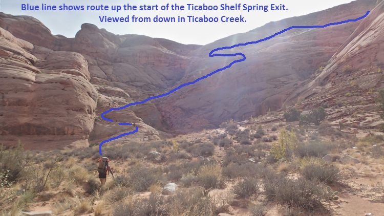
When you get to the large bowl like area on the RDC (southwest) side of Ticaboo Creek, follow up the old cairned cattle trail as shown.
Follow the cairned route
about 400 feet to where
it crosses of the
drainage (wTicShSpgEx02)
then begins to travel
mostly southwest up a
series of about 10
switchbacks up toward
Ticaboo Shelf Spring.
Portions of the
switchbacks up to the
mesa top cross over some
sections of slickrock
making it difficult to
see where the trail
goes. Each of
these spots are short
and just a little
walking around will
allow you to see where
the trail continues.
A little over 0.2 miles
up the switch backs is
the top most switchback
on the cairned route
(wTicShSpgEx03).
From the last switchback
walk west about 1500
feet back to where the
vehicle is parked (pkTicShSpg).
Downloadable GPX files
available at
BG-Gear Store
(easier than manual entry and a great way to support
Bluugnome).
Waypoint naming convention and map symbol information can be found on the Glossary page.
Elevations are approximate.
BEFORE
manually entering coordinates set your system to WGS84 datum and Lat/Lon hddd.ddddd° coordinate format.
Inconsistent datum's and coordinate formats will result in location errors.
Click to show / expand the list of waypoints below........
| South Fork Ticaboo (1) - Drive to Trailhead |
- exTicaboo1
Lat/Lon (WGS84): N 37.69720
W -110.67138
Elev: 4,520 Feet
Exit off of highway 276 onto BLM dirt-road 13400 (between mile markers 25 and 26) going east onto Ticaboo Mesa.
- TicabooDP-01
Lat/Lon (WGS84): N 37.68607
W -110.65188
Elev: NaN Feet
Junction of BLM roads (13400 continues east and 13410 branches off to the south).
To go to the main area of Ticaboo Mesa, continue east on BLM road 13400.
To go to the Smith Fork Canyons, turn south onto BLM road 13410.
- TicabooDP-02
Lat/Lon (WGS84): N 37.67981
W -110.62886
Elev: NaN Feet
Junction of BLM roads (13400 continues east and 13420 branches off to the south).
To go to the main area of Ticaboo Mesa, continue east on BLM road 13400.
Note: BLM road 13420 to the south goes out to Cane Spring Well about 1.25 miles south.
- TicabooDP-03
Lat/Lon (WGS84): N 37.68038
W -110.62628
Elev: 4,565 Feet
Short side road on the left (north) that goes to a camp area.
Stay right to continue on BLM road 13400. Beyond this point the roads will have intermittent rough sections.
About 0.37 miles past here is a fork in the road where the two roads rejoin a short distance later. The low road is typically the smoothest.
- TicabooDP-04
Lat/Lon (WGS84): N 37.67963
W -110.60429
Elev: NaN Feet
Junction of BLM roads (13400 continues north-ish and 13430 branches off to the south).
To go farther out on Ticaboo Mesa, continue north on BLM road 13400.
To go to the roads between Warm Springs Creek and Sevenmile Creek, turn south onto BLM road 13430.
- TicabooDP-05
Lat/Lon (WGS84): N 37.68389
W -110.60153
Elev: NaN Feet
Junction of BLM roads (13400 continues northeast and 13440 branches off to the north).
To go farther out onto Ticaboo Mesa, continue straight northeast on BLM road 13400.
Note: BLM road 13440 to the south goes out to Colt Spring Well about 0.4 miles north.
- TicabooDP-06
Lat/Lon (WGS84): N 37.68667
W -110.59547
Elev: NaN Feet
Junction of BLM roads (13400 continues northeast and 13450 branches off to the north).
To go farther out onto Ticaboo Mesa, continue straight northeast on BLM road 13400.
- TicabooDP-07
Lat/Lon (WGS84): N 37.69529
W -110.58385
Elev: NaN Feet
Junction of BLM roads (13400 continues northeast and 13430 branches off to the south).
To go farther out onto Ticaboo Mesa, turn south onto BLM road 13430.
To go to Trough, SF Ticaboo or the Sleepytime Trio Canyons, continue northeast on BLM road 13400.
- exBLM-13460
Lat/Lon (WGS84): N 37.69800
W -110.57872
Elev: NaN Feet
Junction of BLM roads (13400 continues northeast and 13460 branches off to the north).
To Go to the parking for Trough, SF Ticaboo or the Sleepy Time Trio Canyons, turn north onto BLM road 13460 toward Shelf Spring.
To follow the rough-road option to Double Enendre you can continue northeast on BLM road 13400 but it is not recomended.
- pkTicShSpg
Lat/Lon (WGS84): N 37.70146
W -110.58039
Elev: 4,820 Feet
Wide parking spot large enough for many cars near the end of BLM Road 13460 near a tank and trough by Ticaboo Shelf Spring.
To go to Trough Canyon, walk north down the dirt slope almost 500 feet to drop in.
To go to Upper South Fork Ticaboo Canyon or the Sleepytime Trio look northwest to a cone shaped hill about 0.37 miles away. Walk west over a couple small drainages then up a slope to get to the next higher shelf to the left of the hill.
|
| South Fork Ticaboo (2) - Approach |
- pkTicShSpg
Lat/Lon (WGS84): N 37.70146
W -110.58039
Elev: 4,820 Feet
Wide parking spot large enough for many cars near the end of BLM Road 13460 near a tank and trough by Ticaboo Shelf Spring.
To go to Trough Canyon, walk north down the dirt slope almost 500 feet to drop in.
To go to Upper South Fork Ticaboo Canyon or the Sleepytime Trio look northwest to a cone shaped hill about 0.37 miles away. Walk west over a couple small drainages then up a slope to get to the next higher shelf to the left of the hill.
- SF-Tic-RP01
Lat/Lon (WGS84): N 37.70051
W -110.58669
Elev: 5,035 Feet
Up on the next higher shelf after walking west from Ticaboo Shelf Spring. To continue to SF Ticaboo Canyon or Sleepytime Trio, veer right to walk north west towards Mount Ellsworth roughly following the rim of the hill you just came up.
- pkSF-TicOpt
Lat/Lon (WGS84): N 37.70658
W -110.59337
Elev: 5,125 Feet
When walking into South Fork Ticaboo, the route meets a road here. Continue walking northwest along the road toward Mount Ellsworth. The road fades away about 250 feet farther where you will route find your way through open desert.
Optionally you could drive to here and start the route setting a shuttle / exit vehicle at Ticaboo Shelf Spring. Doing the shuttle saves only mile of walking and would likely save very little if any time.
- SF-Tic-RP02
Lat/Lon (WGS84): N 37.70871
W -110.59676
Elev: 5,200 Feet
Bottom of a slope to go up to the northwest to get up onto a very wide dirt ridge running north. This dirt slope is steep with lots of loose rock and a bit of work to go up gaining about 200 vertical feet over 600 hundred horizontal feet. After getting to the top of the hill, veer right to walk north along the wide ridge.
- SF-Tic-RP03
Lat/Lon (WGS84): N 37.71358
W -110.59892
Elev: NaN Feet
Crossing over a minor drainage on the way over to South Fork Ticaboo. About 800 feet farther north is a much larger and deeper drainage that is is easier to cross by veering a little left and travel up the side to cross it where it is more shallow.
- SF-Tic-RP04
Lat/Lon (WGS84): N 37.71727
W -110.59868
Elev: NaN Feet
Crossing over a large drainage up higher where it is more shallow. As you continue north, note what looks like a small dirt hill on the horizon. Route find your way through the desert aiming a little left of the dirt hill.
- SF-Tic-RP05
Lat/Lon (WGS84): N 37.72025
W -110.59814
Elev: NaN Feet
From the rim here, route find your way down the sloped dirt and slickrock into the drainage for Upper South Fork Ticaboo Creek.
- ySF-Tic-Tp
Lat/Lon (WGS84): N 37.72167
W -110.59747
Elev: 5,530 Feet
Top of Upper South Fork Ticaboo. About 60 feet southeast down canyon is the first drop in the canyon.
To go over to the Sleepytime Trio, cross Upper SF Ticaboo and continue northeast up the other side about 500 feet to the top of a small short drainage running down to the southeast.
|
| South Fork Ticaboo (3) - The Canyon |
- ySF-Tic-Tp
Lat/Lon (WGS84): N 37.72167
W -110.59747
Elev: 5,530 Feet
Top of Upper South Fork Ticaboo. About 60 feet southeast down canyon is the first drop in the canyon.
To go over to the Sleepytime Trio, cross Upper SF Ticaboo and continue northeast up the other side about 500 feet to the top of a small short drainage running down to the southeast.
- dSF-Tic-R1
Lat/Lon (WGS84): N 37.72156
W -110.59724
Elev: NaN Feet
Rap 1 - Upper South Fork Ticaboo (50 feet rope travel). Anchored from trees and drops about 50 feet.
Note:
This rap can be bypassed by walking down canyon about 250 feet on the LDC side then crab walking a very steep slope into the canyon. Not recommended for most parties but possible.
- dSF-Tic-R2
Lat/Lon (WGS84): N 37.72127
W -110.59654
Elev: NaN Feet
Rap 2 - Upper South Fork Ticaboo (140 feet rope travel). Anchored RDC from a tree starting down gently sloped slab rolling off to vertical using about 140 feet of rope. Continuing down canyon is a long wash walk with a few minor downclimbs.
- SF-Tic-RP06
Lat/Lon (WGS84): N 37.71949
W -110.59272
Elev: 5,225 Feet
Drop of about 15 feet to a muddy pool easily bypassed on the LDC side. About 150 feet farther is another short drop to bypass RDC then a partner assit downclimb on the RDC side into a pothole and the top of then next rap.
- dSF-Tic-R3
Lat/Lon (WGS84): N 37.71911
W -110.59223
Elev: NaN Feet
Rap 3 - Upper South Fork Ticaboo (25 feet rope travel). Anchored from rocks in a shallow pothole or a pack-drag anchor and drops about 20 feet down a sloped wall to a waist-deep pothole. The first half of the rappel can be downclimbed and the lower half can be a controlled slide. When dry some people may be able to downclimb the whole rap.
After rap 3 is a sloped downclimb of about 20 where the last 8 feet is best done with a partner assist to a chest deep pothole and is a super fun slide when the pothole is filled. Followed by another sloped downclimb of about 15 feet to a waist deep pothole. Followed by a 6 foot downclimb to a couple shallow potholes just before the next rappel.
- dSF-Tic-R4
Lat/Lon (WGS84): N 37.71849
W -110.59191
Elev: NaN Feet
Rap 4 - Upper South Fork Ticaboo (190 feet rope travel, IF the anchor webbing is extended to the top of the drop). Anchored from rocks and uses about 190 feet of rope dropping down 25 feet drop to a long pool that can be a swimmer then over a slowly rolling lip going vertical with a final 50 foot free hanging portion. The anchor is set in one of the smaller potholes up canyon and with webbing extended over to the top of the drop. If the anchor webbing is not extended, a longer rope will be needed. Optionally a sandtrap or water trap can be used on the long pool to break the rappel up into two rappels.
Note:
The bottom of this rap is in a portion of the canyon that funnels a lot of wind and can be very cold if in wet wetsuits. Having a windbreaker or something similar helps a lot.
Continue down canyon through a few small potholes and one partner assitable downclimb to a cold pool.
- dSF-Tic-R5
Lat/Lon (WGS84): N 37.71806
W -110.59131
Elev: NaN Feet
Rap 5 - Upper South Fork Ticaboo (90 feet rope travel). Anchored from rock debris and drops about 90 feet to a pool where you swim under an arch to the next rap.
- dSF-Tic-R6
Lat/Lon (WGS84): N 37.71797
W -110.59114
Elev: NaN Feet
Rap 6 - Upper South Fork Ticaboo (150 feet rope travel). Anchored from rock debris under water in a pool after swimming under an arch and drops about 150 feet to the canyon floor in wide wash.
- SF-Tic-RP07
Lat/Lon (WGS84): N 37.71727
W -110.59143
Elev: NaN Feet
Large drop in the wash bypassed going up and over on the LDC side.
- SF-Tic-RP08
Lat/Lon (WGS84): N 37.71604
W -110.59210
Elev: 4,799 Feet
Drop in the wash bypassed up and over on the RDC side or downclimb to a pool and walk the RDC dirt ledge.
- SF-Tic-RP09
Lat/Lon (WGS84): N 37.71527
W -110.59236
Elev: 4,660 Feet
Canyon begins to pinch down again where you need to scramble through and over boulder debris.
- dSF-Tic-R7
Lat/Lon (WGS84): N 37.71487
W -110.59215
Elev: 4,626 Feet
Rap 7 - Upper South Fork Ticaboo (150 feet rope travel). Anchored from a pinch point on the down canyon side of a boulder and drops about 150 feet. To get to the anchor you can downclimb around the LDC side of the boulder which feels exposed or if the rabbit hole is not filled in downclimb under the boulder through the rabbit hole.
- ySF-Tic-Bt
Lat/Lon (WGS84): N 37.71422
W -110.59179
Elev: 4,700 Feet
Bottom of the technical portion of Upper South Fork Ticaboo. From here walk the wash down canyon about 1.3 miles to the cattle trail exit on the RDC side leading up to Ticaboo Shelf Spring.
|
| South Fork Ticaboo (4) - Exit |
- ySF-Tic-Bt
Lat/Lon (WGS84): N 37.71422
W -110.59179
Elev: 4,700 Feet
Bottom of the technical portion of Upper South Fork Ticaboo. From here walk the wash down canyon about 1.3 miles to the cattle trail exit on the RDC side leading up to Ticaboo Shelf Spring.
- yRudeAwakenBt
Lat/Lon (WGS84): N 37.70973
W -110.58690
Elev: 4,355 Feet
Bottom of Rude Awakening where it meets South Fork Ticaboo Creek.
To exit turn left and walk southeast down South Fork Ticaboo Creek about 0.8 miles to a wide open bowl like area on the RDC (west) side. You will pass two large drainages on the RDC side on the way to the bowl.
- yTicaMes50Bt
Lat/Lon (WGS84): N 37.70580
W -110.58190
Elev: NaN Feet
Bottom end of a slot dropping down to the southern most fork of the South Fork of Ticaboo Creek. No technical value but hiking in from the bottoom is a quiet serene feeling and worth the trip for some scenic value. You can hike up about 350 up into the canyon with only one boulder to scramble over. The journey ends when you get to the base of a drop of about 60 feet or so high.
- yTroughBt
Lat/Lon (WGS84): N 37.70546
W -110.57974
Elev: 4,290 Feet
Bottom of Trough Canyon where it meets the South Fork of Ticaboo Creek. Looking back up canyon it looks like Trough Canyon is nothing more than a pour off from the slickrock above.
- jTicShSpgEx
Lat/Lon (WGS84): N 37.70453
W -110.57676
Elev: 4,280 Feet
Junction where you leave Ticaboo Creek and start up the Ticaboo Shelf Spring Exit route. THis route is mostly cairned and is an old cattle trail.
- wTicShSpgEx01
Lat/Lon (WGS84): N 37.70380
W -110.57650
Elev: NaN Feet
Bottom of the cairned cattle trail up to Ticaboo Shelf Spring.
- wTicShSpgEx02
Lat/Lon (WGS84): N 37.70295
W -110.57630
Elev: NaN Feet
Cairned trail crosses the draiange here to turn and travel mostly southwest up a series of about 10 switchbacks. Portions of the switchbacks up to the mesa top cross over some sections of slickrock making it difficult to see where the trail goes. Each of these spots are short and just a little walking around will allow you to see where the trail continues.
- wTicShSpgEx03
Lat/Lon (WGS84): N 37.70200
W -110.57783
Elev: NaN Feet
Top most switchback on the carined cattle trail.
- wTicShSpngTnk
Lat/Lon (WGS84): N 37.70234
W -110.58009
Elev: NaN Feet
Tank and water trough at Ticaboo Shelf Spring.
- pkTicShSpg
Lat/Lon (WGS84): N 37.70146
W -110.58039
Elev: 4,820 Feet
Wide parking spot large enough for many cars near the end of BLM Road 13460 near a tank and trough by Ticaboo Shelf Spring.
To go to Trough Canyon, walk north down the dirt slope almost 500 feet to drop in.
To go to Upper South Fork Ticaboo Canyon or the Sleepytime Trio look northwest to a cone shaped hill about 0.37 miles away. Walk west over a couple small drainages then up a slope to get to the next higher shelf to the left of the hill.
|