Canyoneering Route Description
Dos Bolsas Cojones Canyon - 4A(B) II R
Ticaboo Mesa, Utah.
05-28-16, 4 people, 1 Day (Travel time in route 5.5 hours)
 First probe into canyon trailing rope from head of canyon.
05-29-16, 3 people, 1 Day (Travel time in route 5.5 hours)
Exit at end of canyon as per route description.
Time Required - 4 to 6 hours
Distance - 1.9 miles Total, 0.2 miles Technical
Rappels - 3 Rappels, Longest Rappel 30 feet.
Bring Ropes up to 75 feet to allow for anchor placement.
Elevation Range - 4855 - 4000 Feet
Shuttle Required - No Vehicle - High Clearance, 4WD if bad road conditions
Permit Required - No
Rappelling and anchor gear, Ropes and or pull cords for rappels up
to 75 feet and 30 feet of 1 inch webbing for sling placement
(longest drop is shorter but you may need this much rope travel on
one of the rappels). Sandtrap or pothsots for anchoring with sand.
Wetsuits not needed (see notes in genearal comments section).
Additional gear needed to set an exit rope to ascend out of the
canyon. 10 feet webbing, 50 foot rope and ascenders.
Most people will be able to handline out of the canyon and not need
ascenders but at least one set should be on hand in case they are
needed.
At about 1000 feet long, Dos Bolsas Cojones Canyon provides
a good half day adventure with some stemming, partner assist downclimbing and
sandtrap anchor practice. For being a short slot next to some other more meaty
options, Dos Bolsas Cojones is surprisingly fun, scenic and challenging.
When rim walking the canyon on exit or when setting the
exit rope, you will have good views over to the final drop of Montezuma
Canyon. If you happen to be there when others are on the final rappel
of Montezuma Canyon, the people help put perspective on just how massive
that ending is. With no people on it for reference it just looks like
a big cliff.
Warning: (Set an exit rope first)
DO NOT drop into Dos Bolsas Cojones Canyon until you have went down to the
exit and set an exit rope that will allow you to ascend out of the canyon
when you get to the end where there is a huge drop off. Dos Bolsas Cojones
is descended down to the top of the big drop then you ascend out an exit rope
you set BEFORE going to the top to enter the canyon. The rope travel needed
is about 50 feet from a cairn anchor in a crack.
Build the exit anchor and
set your exit rope before descending the canyon. Dismantle the anchor when
you leave so the place is kept clear of webbing and other anchor trash for
those who happen to hike around out here.
Be VERY careful of which rock you choose for the base
anchor of your exit rope. There are a lot of rocks around but most are
breakable. There are a few good solid rocks around if you take your time to
figure out which ones they are.
Warning: (short section of high stemming
and loose rock)
Dos Bolsas Cojones Canyon is rated R for a
couple short spots of stemming with fall potential of about 25 feet. There
are places where you will be stemming over 40 feet up off the deck but the
crack below will be so skinny you can not fall more than 5 feet. The
actual depth of the skinny cracks is not known since the crack is only
inches wide and all you see is darkness down in the crack below.
Super loose rock in the upper section of canyon with large flakes that are
ready to break off. We had a lot break and fall when we were first looking
the place over. As more people descend the canyon the loose stuff will
slowly fall away so there will be fewer surprises. Be careful.
A couple spots have the potential to hold water deep
enough to make a mandatory swim but they are very short swims with easy
exits. Both possible swims are in a semi-open and south-facing. It appears the canyon would only hold water after recent rains and
would evaporate off rather fast. Wet suits are not needed but if you visit
when it is cold out, be prepared for a surprise short cold swim.
Dos Bolsas Cojones Canyon got its name from the joking
banter while doing the first probe down the canyon. The canyon is short and
we decided it a good idea to bring in a lot of rope, rig it at the head then
string the rope through the canyon to use as a safety line / umbilical cord
then use our new umbilical cord to re-ascend the canyon. With a bit too much
excitement we stemmed down canyon forgetting ropes and finding a the first
drop a few hundred feet later. I stemmed back up canyon to the head
where we tied to my waist the end of a 300 foot rope, to trail with me, along
with two rope bags containing a 300 foot and 200 foot rope. Later the name
Dos Bolsas Cojones was born from the visual of stemming down canyon with two
large rope bags dangling between my legs.
To get to the Trailhead
Note:
There is a maze of roads on Ticaboo Mesa making it a good idea
to study the map ahead of time and keep a close eye on the map
as you drive.
From Hanksville, UT., drive south on highway 95 for 26 miles to
the junction of highways 95 and 276.
From the junction, drive south on HWY-276 for 25.6 miles then
turn left (east) onto BLM dirt-road 13400 between mile markers
25 and 26 (extTicaboo1).
About 1.5 miles from the highway is a junction (TicabooDP-01)
of BLM roads, 13400 continues east and 13410 branches off to the
south. Continue east on BLM road 13400. Note: If you were headed
to the Smith Fork area you would turn south onto BLM road 13410.
About 2 miles farther is another junction
(TicabooDP-02) of BLM roads, 13400 continues east and 13420
branches off to the south. Continue east on BLM road 13400.
Note: BLM road 13420 to the south goes out to Cane Spring Well
about 1.25 miles south.
About 0.2 miles farther is short side road (TicabooDP-03) on the
left (north) that goes to a camp area.
Stay right to
continue on BLM road 13400. Beyond this point the roads
will have intermittent rough sections.
About 0.37
miles past here is a fork in the road where the two roads rejoin
a short distance later. The low road is typically the
smoothest.
About 1.7 miles farther is another junction (TicabooDP-04) of
BLM roads (13400 continues north-ish and 13430 branches off to
the south).
Continue north on BLM road 13400.
Note: If you were going to the roads between Warm Springs Creek
and Sevenmile Creek, you would turn south onto BLM road 13430.
About 0.3 miles farther is another junction (TicabooDP-05) of
BLM roads (13400 continues northeast and 13440 branches off to
the north).
Continue straight northeast on BLM road 13400.
Note: BLM road 13440 to the south goes out to Colt Spring Well
about 0.4 miles north.
About 0.5 miles farther is a junction (TicabooDP-06) of BLM
roads (13400 continues northeast and 13450 branches off to the
north).
Continue straight northeast on BLM road 13400.
About 0.9 miles farther is a junction (TicabooDP-07) of BLM
roads (13400 continues northeast and 13430 branches off to the
south).
Turn south onto BLM road 13430.
Note: If you were
going to Tough, SF Ticaboo or Sleepytime Trio Canyons you would
continue northeast on BLM road 13400.
About 700 feet farther is a fork in the road (extWarmSpring).
At this fork stay left to continue toward the East Branch of
Seven Mile Creek.
About 0.4 miles farther is another fork in the road
(ext7MileCkEB). Veer right (more south) to continue toward
the East Branch of 7 Mile Creek.
About 1.0 mile farther is a junction (7MileCkEBDP-01) where a
side road joins in from the left. Continue straight
(south) past the side road.
About 0.5 miles farther is a jog in the road (7MileCkEBDP-02)
near an old stock pond. Turning left leads to a berm with
a survey marker by a stock pond. Veer right to continue south.
About 1.1 miles farther will be a wide pull out on the left side
of the road (pkHardDayHarvy). Park here for the start of
the Hard Day Harvey route. This parking spot is about 350
feet after the road turns left (east) around a corner.
To leave the Exit Vehicle / Escape Pod
No exit vehicle is needed. This is done as an out and back
route.
GPS coordinate information listed at the bottom. For information about waypoint naming and map symbols, refer to the
Glossary page.

Click the links for maps of the route.
Map of the drive into the route.
Map of the entire route.
Map of the technical section.
The Approach:
From the parking area (pkHardDayHarvy)
walk east along the road
for about 150 feet then
veer right and leave the
road walking across the
desert heading south
east.
About 650 feet from the
road walk around the
head (wHardDayRP-01) of
a side drainage that
runs southwest down into
the Hard Day Harvey
drainage. After
getting around the head
of the side drainage
veer right and walk
south west across the
desert.
About 0.2 miles farther
will be where you drop
down (wHardDayRP-02) to
the bench below.
About 200 feet farther
you will drop down
(wHardDayRP-03) to the
next lower bench.
Continue southwest.
About 350 feet farther
the route starts out
onto (wHardDayRP-04) an
obvious ridge that
continues south west.
Continue south west
along this ridge and
enjoy the good views
over part of Lake Powel
to the left (south).
About 0.3 miles farther
is where the point ends
and drops down onto
slick rock
(wHardDayRP-05).
About 150 feet after
starting down the slick
rock from the point of
the ridge is a large
drop off. Look for
a steep slide / down
climb on the right
(west). The last
15 feet of the down
climb (wHardDayRP-06) is
a steep slide where some
may want assistance.
From the bottom of the
down climb, walk about
90 feet south around to
the base of the slick
rock point (jHardDayExtApr).
Make note of this spot
and what it looks like.
You will be coming back
to this spot on your
exit as you reverse the
approach route.
To continue down to the
head of Dos Bolsas
Cojones, look south down
the rolling slickrock
toward Lake Powell.
You will be able to see
a prominent vertical
wall about 0.5 miles
south. That
vertical wall has a slot
running down along it.
You will also be able to
see another slot about
0.3 miles away.
Dos Bolsas Cojones is
hidden from view just
past the closer of the
two slots.
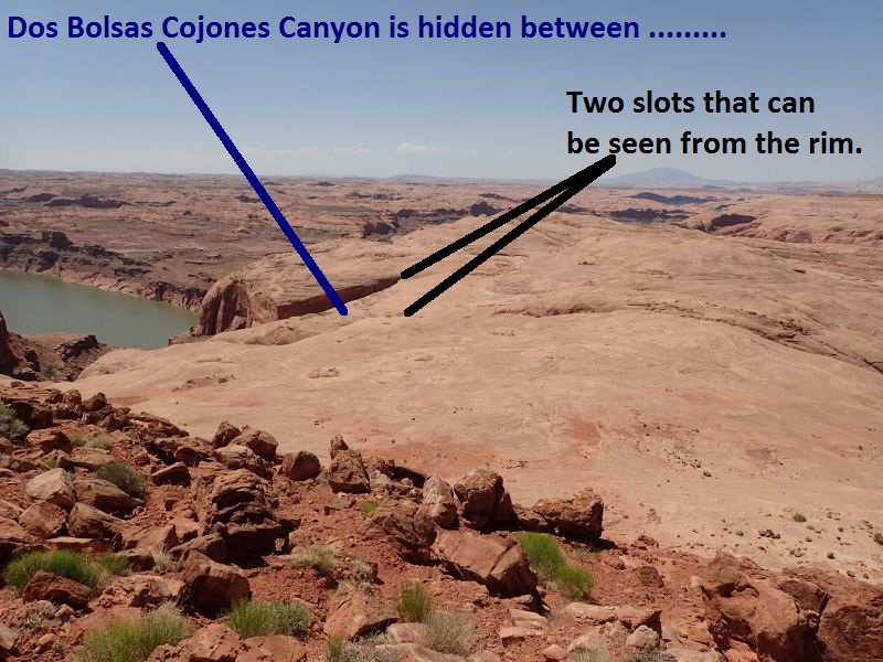 When looking down from the
rim on the approach, Dos
Bolsas Cojones is hidden
from view between two slots
that can be seen.
When looking down from the
rim on the approach, Dos
Bolsas Cojones is hidden
from view between two slots
that can be seen.
Once down on rolling
slickrock, route find south
about 450 feet to where you
can cross over the top end
of a vertical wall
(DosBolsas01) leading down
to the first slot you could
see from the rim.
After crossing over the the
top of this vertical wall,
route find south down
slickrock about 400 feet to
where you will have a good
view (DosBolsas02) over the area and see
the 3 slots running down
toward the lake.
Continue south about 500
feet down to the middle slot
which is Dos Bolsas Cojones.
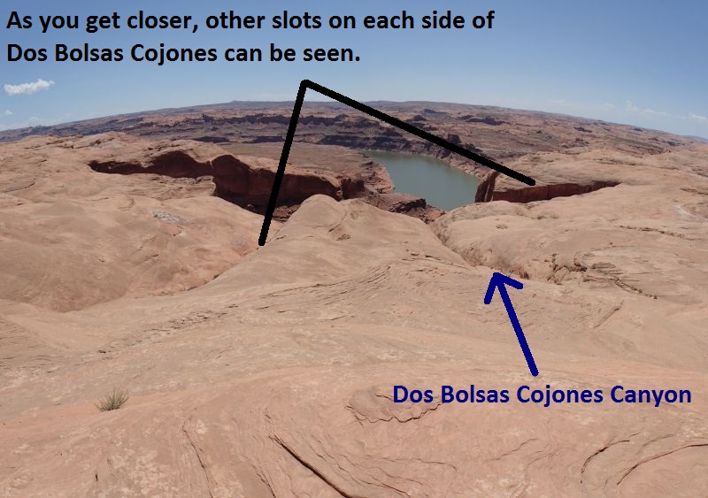 For visual reference you
should see the slot to the
left (east) which is the one
you just crossed over on the
way here. You should also
see a tall vertical wall to
the right (west) about 1500
feet away with another slot
running down along the base
of the wall. The middle slot
directly down the slickrock
to the south is Dos Bolsas
Cojones.
For visual reference you
should see the slot to the
left (east) which is the one
you just crossed over on the
way here. You should also
see a tall vertical wall to
the right (west) about 1500
feet away with another slot
running down along the base
of the wall. The middle slot
directly down the slickrock
to the south is Dos Bolsas
Cojones.
When you get to where the
deep slot for Dos Bolsas
Cojones starts (yDosBolsasTp)
you will need to go set an
exit rope to get out of the
lower end of the canyon
BEFORE you enter Dos Bolsas
Cojones.
Set the Exit
Rope BEFORE you drop
down the canyon:
From the
head of Dos Bolsas
Cojones (yDosBolsasTp),
Walk along the LDC
(east) rim of the canyon
route finding your way
southeast toward Lake
Powell. About 800
feet down the slickrock
will be a section too
steep to walk down.
When you get there walk
left (east) a few feet
to find a wide ramp
leading a few feet down
to the top of a crack /
cross joint
(DosBolsas08).
Galumph about 10 feet
down this crack to get
to more easy walking
down steep slickrock.
About 250 feet farther
the slickrock levels off
to a large landing with
a lot of rock debris
(DosBolsas07).
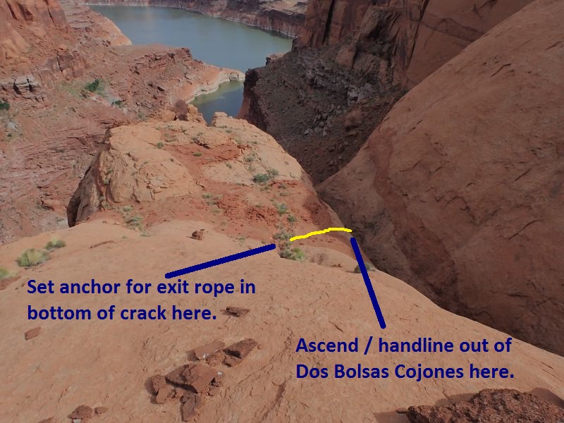
Look to the right to
find another crack /
cross joint running down
to the flat area here.
At the bottom of the
cross joint the crack is
only about 12 inches
deep then opens up and
turns to a pour off like
area down into the side
of the canyon. Set the
anchor rock for your
exit rope down in the
crack, pile rocks on top
of it and run the rope
over to the edge and
down into the canyon via
the shallow pour off.
This offers the best
spot to anchor and exit
the canyon.
You will use about 50
feet of rope travel from
anchor to floor.
Some of the rocks are
fragile so be careful
and choose a solid rock
as your base rock for
your anchor.
Build the exit anchor and
set your exit rope before descending the canyon. Dismantle the anchor when
you leave so the place is kept clear of webbing and other anchor trash for
those who happen to hike around out here.
After setting your exit
rope, return up the
slickrock back to the
head of the canyon.
 As you get down to the
bottom of the steep
slickrock, set the exit
anchor in a crack and
run the rope down a wide
shallow pour off to the
canyon floor.
As you get down to the
bottom of the steep
slickrock, set the exit
anchor in a crack and
run the rope down a wide
shallow pour off to the
canyon floor.
The Canyoneering / Technical Section:
From the head of
Dos Bolsas Cojones (yDosBolsasTp)
after setting your exit
rope, start down the
slot.
About 40 feet after the
slot starts, is an easy
stem downclimb of about
10 feet where you walk
under some rock and are
in a deep narrow slot.
Stem down canyon about
25 feet off the deck as
the floor quickly drops
out from under you.
After about 60 feet of
stemming you are still
up off the deck a
significant distance but
your line of travel is
only 5 or 10 feet above
where the walls are too
narrow for you to fit.
Continue stemming
down canyon about 175
feet gradually working
your way upward to the
top of the constriction
that prevents you from
staying low. The
combination if multiple
features on near
vertical walls makes
movement moderately
difficult. Since the
walls are too narrow for
you to fall a
significant distance, it
is easy to lose
awareness that you are
over 40 feet up at
times. When one of the
many loose chunks of
canyon walls fall off as
you touch it, you are
reminded of the actual
depth of the sliver like
crack below.
Be very careful
since there is a lot of
loose rock on the walls
in this upper section.
From the top of the
first constriction
(DosBolsas03) it is a
sloped stem at about 45
degrees down toward rap
1 about 90 feet down
canyon.
Rap 1 (dDosBolsasR1) is
anchored from a knot
chalk using a choke
stone about 20 feet back
from the drop and drops
about 30 feet with the
last half being free
hanging. Be careful to
extend the webbing all
the way over the lip and
pull the rope from
farther down canyon to
avoid sticking the rope
in a rope eating crack
part way down the rap.
At the bottom of rap 1
is a chamber to walk the
sandy floor over to a
shorter section of
easier stemming for
about 50 feet down
canyon up to the top of
a second constriction.
Stemming to the second
constriction is easier
since it shorter
distance, not as high,
has better quality rock
and has more features on
the wall.
From the top of the
second constriction
(DosBolsas04) stem
downclimb about 20 feet
down a skinny crack a
little more than a foot
wide to 2 narrow pools
to easily galumph over.
The pools are very nasty
water and appear to have
an oil slick on them
from lots of bird poop.
Rap 2 (dDosBolsasR2)
about 130 feet down
canyon is anchored from
a sandtrap about 40 feet
back and drops about 30
feet down a narrow
vertical slot. Rap 2
only drops about 30 feet
but 75 feet of rope may
be used depending on
sandtrap placement. It
may be a good idea to
stem up about 8 feet
when pulling the rope to
get a better angle and
avoid rope grooves and
make the pull smoother.
Rap 2 may possibly
be downclimbed but would
be a little sketchy
getting into and down
the first 10 feet due to
carnivorous rock and
wide flaring walls. The
later part of rap 2
would be an easy stem
down in a narrow slot
with parallel semi
smooth walls.
About 130 feet down
canyon is the top of a
section with shallow
potholes (DosBolsas05).
To start into this
section carefully
traverse over to the RDC
side then crab walk /
scramble down steep
slickrock into a trough
like area. A meat anchor
for all but the last man
is a good idea here.
Just after getting into
the trough area is a
drop of about 12 feet
that works well as a
combination partner
assist / pack drag where
taller people will be
best used. This is a
reachy partner assist
but goes easier than it
looks using the pack
drag in combination. At
the bottom of this drop
is a pothole that could
be a swimmer for a few
feet if full but looks
like it will usually be
less than waist deep.
Just after is one more
drop of abut 10 feet
where spreading wide
works well and a partner
assist may be useful.
Rap 3 (dDosBolsasR3) is
anchored from a sandtrap
set about 20 feet back
and drops about 30 feet
to a huge pothole. Most
of the rap is slightly
sloped with the last 8
feet overhung. The huge
pothole below has water
line indicating this may
at times be a full swim
when full with an easy
walk out. There are many
rocks down canyon of
here which could be
farmed up to create a
cairn anchor if desired.
After rap 3 galumph down
canyon about 120 feet to
the exit point where you
will find your rope
hanging from the rim
(assuming you remembered
to set it prior to
entering the canyon).
From where you exit the
canyon from the exit
rope (DosBolsas06-EE)
ascenders can be used if
desired / needed. Only
the first 4 feet of the
wall is vertical before
it starts to roll to
less than vertical. most
people will be able to
hand line out of the
canyon here.
If you want to go check
out the big drop at the
end of the canyon
galumph down canyon
about 150 feet to look
over the big drop.
A large rock horn could
potentially be used as
an anchor here to do the
big drop down to almost
lake level but has not
been confirmed.
The Exit:
After
hand lining / ascending
up out of Dos Bolsas
Cojones
(DosBolsas06-EE),
dismantle the exit
anchor and route find
your way back to the
canyon head. Next
reverse the approach
route to exit back to
the trailhead / parking.
Downloadable GPX files
available at
BG-Gear Store
(easier than manual entry and a great way to support
Bluugnome).
Waypoint naming convention and map symbol information can be found on the Glossary page.
Elevations are approximate.
BEFORE
manually entering coordinates set your system to WGS84 datum and Lat/Lon hddd.ddddd° coordinate format.
Inconsistent datum's and coordinate formats will result in location errors.
Click to show / expand the list of waypoints below........
| Dos Bolsas Cojones (1) - Drive in to Trailhead |
- extTicaboo1
Lat/Lon (WGS84): N 37.69720
W -110.67138
Elev: 4,520 Feet
Exit off of highway 276 to get to the Ticaboo Mesa area. Turn east and leave the highway on a dirt road. Near Mile post 25.
- TicabooDP-01
Lat/Lon (WGS84): N 37.68607
W -110.65188
Elev: NaN Feet
Continue straight for the main area of Ticaboo Mesa. Or Turn right (south) here for an alternate route over toward the Smith Fork Canyons.
- TicabooDP-02
Lat/Lon (WGS84): N 37.67981
W -110.62886
Elev: NaN Feet
Road junction with faint road running to the south. Continue straight (east).
Road to the south is about 1.25 miles long and goes down toward Cane Spring Well.
- TicabooDP-03
Lat/Lon (WGS84): N 37.68038
W -110.62628
Elev: 4,565 Feet
Exit to a spot to camp if the roads ahead are too rough.
- TicabooDP-04
Lat/Lon (WGS84): N 37.67963
W -110.60429
Elev: NaN Feet
Junction for a road going south. Continue straiaght (north east) to continue toward Ticaboo Measa. This road junction is near Wild Horse Springs.
- TicabooDP-05
Lat/Lon (WGS84): N 37.68389
W -110.60153
Elev: NaN Feet
Junction for a side road on the left going north. Continue north east toward Ticaboo Mesa.
The road going north is BLM Road 13440 aobut 0.4 miles long and goes over toward Colt Spring.
- TicabooDP-06
Lat/Lon (WGS84): N 37.68667
W -110.59547
Elev: NaN Feet
Junction for a side road going north.
The Road north is BLM Road 13540 and goes out toward Upper South Fork Ticaboo.
- TicabooDP-07
Lat/Lon (WGS84): N 37.69529
W -110.58385
Elev: NaN Feet
Turn off for a side road on the right. Turn right onto the side road and drive southwest.
- extWarmSpring
Lat/Lon (WGS84): N 37.69362
W -110.58484
Elev: NaN Feet
Stay right to go toward the main drainage of Seven Mile Creek and Warm Springs Canyon. Or Stay left to go toward the East Branch of Seven Mile Creek and Ticaboo Mesa.
- ext7MileCkEB
Lat/Lon (WGS84): N 37.69147
W -110.58014
Elev: NaN Feet
Turn right (more south) to continue toward the East Branch of Seven Mile Creek. Or veer left to continue toward Ticaboo Mesa.
- 7MileCkEBDP-01
Lat/Lon (WGS84): N 37.68044
W -110.56997
Elev: NaN Feet
Continuestraight (south) past a side road joining from the left. This road is not shown on all maps.
- 7MileCkEBDP-02
Lat/Lon (WGS84): N 37.67443
W -110.56735
Elev: NaN Feet
Jog in the road near a stock pond. Veer right and continue south. Turning left leads to a berm with a survey marker on it.
- pkHardDayHarvy
Lat/Lon (WGS84): N 37.66329
W -110.55625
Elev: 4,855 Feet
Park here for Hard Day Harvey. Hard Day Harvey is the East Fork of the East Branch of Seven Mile Creek.
|
| Dos Bolsas Cojones (2) - Approach and set exit rope |
- pkHardDayHarvy
Lat/Lon (WGS84): N 37.66329
W -110.55625
Elev: 4,855 Feet
Park here for Hard Day Harvey. Hard Day Harvey is the East Fork of the East Branch of Seven Mile Creek.
- wHardDayRP-01
Lat/Lon (WGS84): N 37.66166
W -110.55490
Elev: 0 Feet
Walk around the head of a side drainage.
- wHardDayRP-02
Lat/Lon (WGS84): N 37.65954
W -110.55701
Elev: 4,840 Feet
Drop down to the bench below.
- wHardDayRP-03
Lat/Lon (WGS84): N 37.65910
W -110.55724
Elev: 4,742 Feet
Drop down to a lower bench again.
- wHardDayRP-04
Lat/Lon (WGS84): N 37.65815
W -110.55764
Elev: 4,770 Feet
Startinjg out onto an obvious ridge running south west. From here you start to get great views over parts of Lake Powel to the south.
- wHardDayRP-05
Lat/Lon (WGS84): N 37.65558
W -110.56049
Elev: 4,710 Feet
End of the point where the route drops down onto slick rock.
- wHardDayRP-06
Lat/Lon (WGS84): N 37.65555
W -110.56104
Elev: 4,660 Feet
Bottom of a down climb on the approach route or up climb on the exit.
- jHardDayExtApr
Lat/Lon (WGS84): N 37.65533
W -110.56115
Elev: NaN Feet
The base of a slick rock point. The Approach and Exit routes for Hard Day Harvey join.
- DosBolsas01
Lat/Lon (WGS84): N 37.65376
W -110.56123
Elev: NaN Feet
Crossing over the top end of a vertical wall leading down to a drainage / slot to the south on the way over to Dos Bolsas Cojones. Route find south down slickrock about 400 feet to where you will have a good view over the area and see the 3 slots running down toward the lake.
- DosBolsas02
Lat/Lon (WGS84): N 37.65269
W -110.56103
Elev: NaN Feet
This is a semi arbitrary spot marked where you can now see 3 slots running down toward Lake Powel. Continue south down to the middle slot which is Dos Bolsas Cojones.
For visual reference you should see the slot to the left (east) which is the one you just crossed over on the way here. You should also see a tall vertical wall to the right (west) about 1500 feet away with another slot running down along the base of the wall. The middle slot directly down the slickrock to the south is Dos Bolsas Cojones.
- yDosBolsasTp
Lat/Lon (WGS84): N 37.65155
W -110.56019
Elev: 4,420 Feet
Top of Dos Bolsos Cojones Canyon. About 40 feet after the slot starts, is an easy stem downclimb of about 10 feet where you walk under some rock and are in a deep narrow slot.
Stem down canyon about 25 feet off the deck as the floor quickly drops out from under you. After about 60 feet of stemming you are still up off the deck a significant distance but your line of travel is only 5 or 10 feet above where the walls are too narrow for you to fit.
Continue stemming down canyon about 175 feet gradually working your way upward to the top of the constriction that prevents you from staying low. The combination if multiple features on near vertical walls makes movement moderately difficult. Since the walls are too narrow for you to fall a significant distance, it is easy to lose awareness that you are over 40 feet up at times. When one of the many loose chunks of canyon walls fall off as you touch it, you are reminded of the actual depth of the sliver like crack below.
- DosBolsas08
Lat/Lon (WGS84): N 37.65012
W -110.55816
Elev: NaN Feet
Top of a crack to downclimb along on the way down and up where there are great views over to the final rap of Montezuma. You will need to stem / galumph this crack for about 10 feet.
On the way down to set the esit rope continue down about 250 feet to where the slickrock levels off and you are in a semi level area with a lot of red and whte rocks all over.
- DosBolsas07
Lat/Lon (WGS84): N 37.64960
W -110.55774
Elev: NaN Feet
Look for a crack / cross joint running down to the flat area here. At the bottom of the cross joint the crack is only about 12 inches deep then opens up and turns to a pour off like area down into the side of the canyon. Set the anchor rock for your exit rope down in the crack, pile rocks on top of it and run the rope over to the edge and down into the canyon via the shallow pour off. This offers the best spot to anchor and exit the canyon.
You will use about 50 feet of rope travel from anchor to floor.
|
| Dos Bolsas Cojones (3) - Canyon |
- yDosBolsasTp
Lat/Lon (WGS84): N 37.65155
W -110.56019
Elev: 4,420 Feet
Top of Dos Bolsos Cojones Canyon. About 40 feet after the slot starts, is an easy stem downclimb of about 10 feet where you walk under some rock and are in a deep narrow slot.
Stem down canyon about 25 feet off the deck as the floor quickly drops out from under you. After about 60 feet of stemming you are still up off the deck a significant distance but your line of travel is only 5 or 10 feet above where the walls are too narrow for you to fit.
Continue stemming down canyon about 175 feet gradually working your way upward to the top of the constriction that prevents you from staying low. The combination if multiple features on near vertical walls makes movement moderately difficult. Since the walls are too narrow for you to fall a significant distance, it is easy to lose awareness that you are over 40 feet up at times. When one of the many loose chunks of canyon walls fall off as you touch it, you are reminded of the actual depth of the sliver like crack below.
- DosBolsas03
Lat/Lon (WGS84): N 37.65114
W -110.55981
Elev: NaN Feet
Top of the first constriction. From here it is a sloped stem at about 45 degrees down toward rap 1 about 90 feet down canyon.
- dDosBolsasR1
Lat/Lon (WGS84): N 37.65095
W -110.55962
Elev: NaN Feet
Rap 1 - Dos Bolsos Cojones. Anchored from a knot chalk using a choke stone about 20 feet back from the drop and drops about 30 feet with the last half being free hanging. Be careful to extend the webbing all the way over the lip and pull the rope from farther down canyon to avoid sticking the rope in a rope eating crack part way down the rap.
At the bottom of rap 1 is a chamber to walk the sandy floor over to a shorter section of easier stemming for about 50 feet down canyon up to the top of a second constriction. Stemming to the second constriction is easier since it shorter distance, not as high, has better quality rock and has more features on the wall.
- DosBolsas04
Lat/Lon (WGS84): N 37.65054
W -110.55917
Elev: NaN Feet
Top of the second constriction to stem to the top of. From here stem downclimb about 20 feet down a skinny crack a little more than a foot wide to 2 narrow pools to easily galumph over. The pools are very nasty water and appear to have an oil slick on them from lots of bird poop.
- dDosBolsasR2
Lat/Lon (WGS84): N 37.65027
W -110.55887
Elev: NaN Feet
Rap 2- Dos Bolsas Cojones. Anchored from a sandtrap about 40 feet back and drops about 30 feet down a narrow vertical slot. Rap 2 only drops about 30 feet but 75 feet of rope may be used depending on sandtrap placement. It may be a good idea to stem up about 8 feet when pulling the rope to get a better angle and avoid rope grooves and make the pull smoother.
Rap 2 may possibly be downclimbed but would be a little sketchy getting into and down the first 10 feet due to carnivorous rock and wide flaring walls. The later part of rap 2 would be an easy stem down in a narrow slot with parallel semi smooth walls.
- DosBolsas05
Lat/Lon (WGS84): N 37.65003
W -110.55852
Elev: NaN Feet
Top of a section with shallow potholes. To start into this section carefully traverse over to the RDC side then crab walk / scramble down the steep slickrock into a trough like area. A meat anchor for all but the last man is a good idea here.
Just after getting into the trough area is a drop of about 12 feet that works well as a combination partner assist / pack drag where taller people will be best used. This is a reachy partner assist but goes easier than it looks using the pack drag in combination. At the bottom of this drop is a pothole that could be a swimmer for a few feet if full but looks like it will usually be less than waist deep.
Just after is one more drop of abut 10 feet where spreading wide works well and a partner assist may be useful.
- dDosBolsasR3
Lat/Lon (WGS84): N 37.64983
W -110.55830
Elev: NaN Feet
Rap 3 - Dos Bolsas Cojones. Anchored from a sandtrap set about 20 feet back and drops about 30 feet to a huge pothole. Most of the rap is slightly sloped with the last 8 feet overhung. The huge pothole below has water line indicating this may at times be a full swim when full with an easy walk out. There are many rocks down canyon of here which could be farmed up to create a cairn anchor if desired.
After rap 3 galumph down canyon about 120 feet to the exit point where you will find your rope hanging from the rim (assuming you remembered to set it prior to entering the canyon).
- DosBolsas06-EE
Lat/Lon (WGS84): N 37.64954
W -110.55785
Elev: NaN Feet
This is where you exit up the escape rope set from the rim prior to descnding the canyon. Ascenders can be used here if desired / needed. Only the first 4 feet of the wall is vertical before it starts to roll to less than vertical. Most people will be able to hand line out of the canyon here.
If you want to go check out the big drop at the end of the canyon galumph down canyon about 150 feet.
- yDosBolsasBt
Lat/Lon (WGS84): N 37.64920
W -110.55752
Elev: 4,000 Feet
Bottom of Dos Bolsas Cojones Canyon. This is where there is a huge drop down to almost lake level. A large rock horn could potentially be used as an anchor here but has not been confirmed.
- DosBolsas07
Lat/Lon (WGS84): N 37.64960
W -110.55774
Elev: NaN Feet
Look for a crack / cross joint running down to the flat area here. At the bottom of the cross joint the crack is only about 12 inches deep then opens up and turns to a pour off like area down into the side of the canyon. Set the anchor rock for your exit rope down in the crack, pile rocks on top of it and run the rope over to the edge and down into the canyon via the shallow pour off. This offers the best spot to anchor and exit the canyon.
You will use about 50 feet of rope travel from anchor to floor.
|