Maps and any accompanying images at bottom of page.
To view picture albums for this or other canyons, visit the
picture album section.
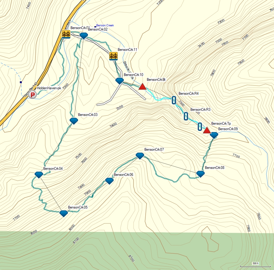 Map of entire route.
1 Benson Creek - Overview Information- BensonCreekINF
(N37.770815 W-112.830475)
Route: Benson Creek Canyon
AKAs: Hidden Haven
::Rating: 3B II::
Area: Dixie National Forest (Cedar Breaks Dist.), Utah
Author Visit: 2008-10-25, 3 people, time 4.75 hours, old approach from 3 miles up canyon.
Author Visit: 2021-09-17, 2 people, time 3.5 hours, bottom up approach.
Time Required: 3 to 4 hours
Distance: Total 2.8 miles, Tech 0.3 miles
Rappels: 4 raps. Longest rap 105 feet
Elevation Range: 7090 - 7940
Shuttle: None
Vehicle: Passenger,
Permit: No
::Gear Requirments:
Rappelling and anchor gear, ropes and pull cords for rappels up to 105 feet and 20 feet of 1 inch webbing for sling placement. Depending on time of year and water flow, rain gear (mostly pants) may be useful to shed water as you will rappel in and next to water. There are no pools so wetsuits are not helpful. Water contact is short lived but can be cold with spring snow run off. It is pretty easy to keep your upper body mostly dry except for the occasional splash but if there is water flow your legs can get significantly wet.::
General Comments:
Back in 2008 I heard about Benson Creek Canyon, located it on a map and approached it from about 3 miles upstream which also required a car shuttle. Over the years people have told me there is a short route up from the bottom that requires no shuttle. In 2021 I finally decided to go back and find the better route which is now described here. The bottom-up route is much shorter with a well-defined trail that I am unsure existed when I first did it. The large trailhead now used certainly was not there so the area has seen some improvement over the years.
Benson Creek Canyon is a fun casual day out with a short canyon. The canyon itself is also an ice climbing destination for ice climbers in the winter.
Driving directions:
No need to set exit vehicle as this is a loop route starting and ending in the same place.
Traveling north on I-15, take exit 75 to exit onto W 200 S Street to the city of Parowan. Drive east on W 200 S for about 2.2 miles to an intersection with a Maverik gas station on the right. Continue straight through the intersection and continue east about 0.4 miles to the intersection with S Canyon Road (highway 143). Turn right onto S Canyon road and drive 5.4 miles to a large gravel parking area on the left (east) with signage for Parowan Canyon Wildlife Management area and the Hidden Haven Trailhead (HiddenHaven-pk).
|
|
2 Benson Creek - Approach- HiddenHaven-pk
(N37.772191 W-112.840387)
Large gravel parking area on the east side of the road with sinage for Hidden Haven Trailhead in the Parowan Canyon Wildlife Management Area.
FOR Benson Creek Canyon approach - follow the trail running north-ish along the creek for about 0.25 miles.
FOR Benson Creek Canyon exit - your route ends where you parked your car.
- BensonCrk01
(N37.774916 W-112.838505)
Large Bridge.
FOR Benson Creek Canyon approach - walk across the bridge and continue east-ish on the main trail for about 300 feet.
FOR Benson Creek Canyon exit - walk across the bridge and follow the trail south-ish about 0.25 miles.
- BensonCrk02
(N37.774843 W-112.837521)
Trail junction.
FOR Benson Creek Canyon approach - Turn right and walk south up a log-lined side-trail for 0.3 miles and do not follow east up the main trail. As you follow the side trail, stay on well-worn trail passing by a couple not-well-used side-trails to overlooks.
FOR Benson Creek Canyon exit - continue west following the main trail for about 300 feet.
- BensonCrk03
(N37.770988 W-112.838075)
Trail junction.
Stay right / straight and walk south up the trail for about 0.25 miles. Do not turn left on the trail going down to the east.
- BensonCrk04
(N37.768554 W-112.840030)
A short section of the trail with overgrown vegetation that may feel like the trail is ending. Continue on the path for about 50 feet to where the vegetation opens up a bit to easy to see trail again. Continue up the steep trail for about 0.25 miles.
- BensonCrk05
(N37.766802 W-112.838642)
Trail begins to level off, veer left to contour northeast along the hillside. Continue northeast for about 1000 feet.
Note: Over the next 1000 feet are multiple trails all running roughly parallel to one-another. Follow whatever path looks like the most well-worn since all the trails rejoin forming one trail again.
- BensonCrk06
(N37.768275 W-112.836086)
Trails rejoin into one trail again. Continue following the trail northeast along the hillside for about 600 feet.
- BensonCrk07
(N37.769412 W-112.834381)
Trail briefly drops down then back up again as it goes around the crest of the ridge and veers right continuing southeast slowly descending. Follow the trail for about 0.25 miles.
- BensonCrk08
(N37.768591 W-112.830994)
Trail starts to drop more steeply dropping north-ish following a ravine for about 700 feet down into a major wash below.
- BensonCrk09
(N37.770344 W-112.830240)
Trail drops into main wash walk northwest down the wash for about 150 feet
- BensonCrkTp
(N37.770592 W-112.830635)
Top entry for Benson Creek Canyon. Steeply dropping section of slickrock. Scramble over to a large tree on the LDC side for the first rappel.
|
|
3 Benson Creek - The Canyon- BensonCrkTp
(N37.770592 W-112.830635)
Top entry for Benson Creek Canyon. Steeply dropping section of slickrock. Scramble over to a large tree on the LDC side for the first rappel.
- BensonCrkR1-2
(N37.770743 W-112.831020)
Raps 1 - 2 - Benson Creek Canyon.
Rap 1 (105 feet rope travel). Anchored LDC from a large tree and 105 feet down a water fall into deep canyon with a couple ledges along the rappel. The next rappel is right at the bottom of this rap.
Rap 2 (40 feet rope travel) Anchored RDC about head high from 2 glue-in anchors drops around the corner over 2 stages.
Almost 300 feet down canyon is the next rappel.
- BensonCrkR3
(N37.771214 W-112.831798)
Rap 3 - Benson Creek Canyon (40 feet rope travel). Anchored LDC from 2 glue-in anchors and drops about 40 feet.
About 350 feet down canyon is the next rappel.
- BensonCrkR4
(N37.771941 W-112.832469)
Rap 4 Benson Creek Canyon (50 feet rope travel). Anchored LDC from 2 glue-in anchors about 10 feet back from the drop and drops about 40 feet.
[Note] There are also anchors on the RDC side out of the water course but the pull may be problematic due to rough rock to pull ropes over.
Walk down the wash about 600 feet.
- BensonCrkBt
(N37.772570 W-112.834236)
Bottom of Benson Creek Canyon. Trail exits up out of the wash on the LDC (west) side. Follow the trail northwest about 400 feet.
|
|
4 Benson Creek - Exit- BensonCrkBt
(N37.772570 W-112.834236)
Bottom of Benson Creek Canyon. Trail exits up out of the wash on the LDC (west) side. Follow the trail northwest about 400 feet.
- BensonCrk10
(N37.772799 W-112.835517)
Trail junction.
FOR Benson Creek Canyon exit - stay right / straight and follow the main trail north-ish about 400 feet.
- BensonCrk11
(N37.773929 W-112.835859)
Bridge. FOR Benson Creek Canyon exit - cross the bridge and continue northwest on the main trail for about 600 feet.
- BensonCrk02
(N37.774843 W-112.837521)
Trail junction.
FOR Benson Creek Canyon approach - Turn right and walk south up a log-lined side-trail for 0.3 miles and do not follow east up the main trail. As you follow the side trail, stay on well-worn trail passing by a couple not-well-used side-trails to overlooks.
FOR Benson Creek Canyon exit - continue west following the main trail for about 300 feet.
- BensonCrk01
(N37.774916 W-112.838505)
Large Bridge.
FOR Benson Creek Canyon approach - walk across the bridge and continue east-ish on the main trail for about 300 feet.
FOR Benson Creek Canyon exit - walk across the bridge and follow the trail south-ish about 0.25 miles.
- HiddenHaven-pk
(N37.772191 W-112.840387)
Large gravel parking area on the east side of the road with sinage for Hidden Haven Trailhead in the Parowan Canyon Wildlife Management Area.
FOR Benson Creek Canyon approach - follow the trail running north-ish along the creek for about 0.25 miles.
FOR Benson Creek Canyon exit - your route ends where you parked your car.
|
|
Downloadable GPX files available at
BG-Gear Store
(easier than manual entry and a great way to support
Bluugnome).
BEFORE
manually entering coordinates set your system to WGS84 datum and Lat/Lon hddd.ddddd° coordinate format.
Inconsistent datum's and coordinate formats will result in location errors.