Canyoneering Route Description
Pork Chop Canyon - 4A(B) IV
Escalante National Monument, Utah.
06-13-20, 6 people, 1 Day (Travel time in route 12.25 hours)

Time Required - 11 to 13 hours
Distance - 10.2 miles Total, 2.4 miles Technical
Rappels - 5 Rappels, Longest Rappel 70 feet.
Elevation Range - 5570 - 6590 Feet
Shuttle Required - No Vehicle - High Clearance
or carefully driven passenger car
Permit Required - No
Rappelling and anchor gear, Ropes and or pull cords for rappels up
to 100 feet and 20 feet of 1 inch webbing for sling placement. The
longest rap is 70 feet but a 100 foot rope will be helpful for the
exit climb-out. Sandtrap, Watertrap recommended to simplify
some of the raps. If no no Sandtrap or Watertrap, you may need
to be more creative with anchor building and or farm materials to
build anchors. Wet suites recommended in case of wet
conditions.
Pork Chop Canyon is the Upper North Fork of Choprock Canyon
and also called Poison Ivy Fork of Choprock in Steve Allen's book Canyoneering
3.
Pork Chop Canyon is a long fun day but has a high pay to play ratio.
The route has multiple spots to practice partner assists, short sections of
stemming, wide open walking, narrow corridors, swimming, some incredible arches
and a climb out exit that requires a decent climber to get out. Be prepared for
a long day with a few challenges. If you like long day adventure routes,
this is a good one. On our visit in May 2020 most of the water was waist
deep but a lot of it had water lines indicating there could be a lot of
swims if in wet conditions.
The technical rating of 4 is due to the recommendation
of Sandtrap and or Watertrap and the added difficulty of the climb-out exit
from the canyon. the A(B) rating for water is due to the canyon being
mostly dry but does have sections of wading or swimming where a wet suit is
a good idea to have on hand.
Good map reading and or GPS skills required for this
route. Navigating up to and across the top of Silver Falls Bench to the drop in
for the canyon and navigating the exit route requires attention to navigate the
convoluted terrain. The approach route up to and through the sandstone
loaves to the mesa top can be a little convoluted but not too hard to find.
It is highly recommended that you pay careful attention to a few key points
as you navigate this, since you will be reversing that portion of the
approach as the final portion of your exit. Paying attention to the
navigation through the loaves and the trails down to the cars will help save
some navigation effort on the way out.
Getting up to and down off the Silver Falls Bench we
found a route up through the small canyon at the far northeast end of the
mesa that is fun scrambling up and navigating through the sandstone loaves.
There are a few moderately challenging spots on the way up through the
slickrock maze. On our re-visit we were shown another route off the
mesa using another small canyon down the south side of the mesa about 1.5
miles west of our approach canyon. All I have to say about that other
route is "it goes, but good luck navigating that! The far north canyon
described here is best for both the approach and exit.
Steve Allen's book Canyoneering 3 gave
basic directions to the exit route we used. The exit route has you scramble up
along the top of an arch to a large ledge system which is then followed to a
climb-out to the rim using a set of moqui (moki) steps then follows up a
weakness to the next higher rim. The first person up the moki steps can go up
pack-free trailing the end of a rope to then belay those who follow. The first
12 feet uses the moqui steps and is difficult for those who do not climb. The
rest of the route is pretty easy scrambling up a weakness to a short 4 foot
upclimb / mantle to the rim above. The mantle at the top is not relatively easy
but is exposed to a 60 foot-ish foot drop. The first person up can tie off
the rope to a nearby arch for those who follow using ascenders to self belay as
they climb. The first person's back pack (tied to the end of the rope) is
then hauled to the rim. The exit is not for the faint of heart as it is exposed
and has a difficult start. The first person up should be a skilled upclimber and
at least a little climbing history may be a good idea. I did not measure the
exact amount of rope needed for the exit climb but 100 feet or rope will be more
than enough.
May 2020 John and I went to scout a way up onto Silver Falls
Bench and see if we could find a way up to and an exit from a canyon we wanted
to explore. After trying several options up through maze-like sandstone loaves,
we found a route up to the mesa then rim walked over 2 miles of canyon looking
over the edge where possible to gauge the canyon. John had notes along about an
exit from the canyon mentioned in Steve Allen's Book, Canyoneering 3. Even
standing right over the exit we almost did not find it but with a bit of poking
around finally did. Looked a little airy but doable. On the long
hike back to the cars we agreed the canyon looked fun and worth a visit to
descend with friends. Fast-forward a few weeks and Tracy kept telling me she
wanted to do a route a friend was calling Pork Chop. Each time she suggested we
add Pork Chop to the mix of a particular weekend trip, I would tell her I can
not plan that since I do not know where it is. Fast-forward a few more
weeks to when John and I got the interest of a few friends to go back with us to
our Silver Falls Bench Canyon. While planning our return trip, a friend sent us
a track for the Pork Chop route Tracy kept talking about. What a crazy surprise
to find out we were talking about the same place!
To get to the Trailhead
From the town of Boulder Utah turn off of highway 12 onto the
Burr Trail Road. Follow the Burr Trail Road east for about 18.4
miles to an exit to a dirt road on the right (south) which is
the first turn off to the Wolverine Loop Road (extWolverine1).
Do not turn off onto this dirt road.
Continue on the paved Burr Trail another 10.5 miles to the
second turn off for the Wolverine Loop Road (exWolverine2). Turn
right onto the Wolverine Loop Road and drive the dirt road for
8.1 miles to the turn off onto the Moody Road (exMoodyCyn).
Turn left (south) onto the Moody Road and drive 2.7 miles to a
road junction on the right (west) for the Silver Falls Road (exSilverFalls).
Continue past the Silver Falls road junction and continue south
on the Moody Canyon Road for 1.8 miles to a small almost
un-noticed pull out (pkPorkchop) on the left (east). Park
here to start the Pork Chop route.
To leave the Exit Vehicle / Escape Pod
No exit vehicle is needed. This is done as a loop route.
GPS coordinate information listed at the bottom. For information about waypoint naming and map symbols, refer to the
Glossary page.

Click the links for maps of the route.
Map of the drive into the route.
Map of the entire route.
Map of the approach.
Map - zoom in of canyon 1.
Map - zoom in of canyon 2.
The Approach:
From the small clearing
on the east side of the
road for parking
(pkPorkchop), walk west
across the road walking
rolling dessert where
the occasional cairn may
be found. Follow the
cairned route leading to
then up along the south
side of a large gully.
About 0.25 miles from
the parking spot the
cairned route meets an
old road (Porkchop01).
Turn right (north) and
walk about 90 feet down
the road to the apex of
a turn crossing a small
gully.
At the apex of this turn
in the road
(Porkchop02), turn left
and walk southwest away
from the road up a small
shallow gully which soon
turns to a large shale
stairway like path. Do
not go northwest up the
continuation of the
larger gully.
As the shallow gully
fades away and the slope
gets little more gentle
(Porkchop03), continue
up the slope to the west
for another 250 feet to
the top out of the hill.
When the hill tops out
(Porkchop04), do not
drop down the other side
but instead turn right
and contour north on
mostly level terrain for
about 225 feet to the
crest of a wide ridge
going up to the west.
From the crest of a
ridge (Porkchop05) going
up to the west toward
the base of the cliffs.
Follow west up the ridge
where you will soon find
cairns and a faint path
leading up the wide
ridge toward the base of
the cliffs above. The
cairns marking the trail
are intermittent and the
trail is not yet well
formed (May 2020) but
taking your time to look
will help keep you on an
easy route up. Losing
the trail here is
rewarded with more
effort in loose rock and
dirt.
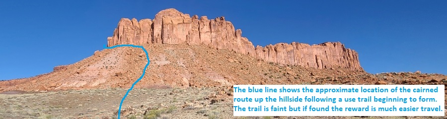
About 1000 feet up the
ridge the cairned route
tops out and meets the
base of the cliff wall
(Porkchop06), turn left
and follow well traveled
use trails south along
the base of the walls
then slowly wrapping
around west then
northwest continuing
along the base of the
cliff wall.
as the trail around the
base of the cliff
briefly fades
(Porkchop07) continue
northwest following the
base of the wall. Each
time you think you may
have lost the trail,
scramble up to the base
of the cliff wall to
find the trail again. Do
not stray too far from
the base of the wall or
you will lose the trail.
A few hundred feet
farther the trail goes
behind a large arch
(Porkchop08).
Almost 400 feet farther
the trail dumps into a
large drainage
(Porkchop09), continue
north up the drainage
about 300 feet to a
large fork.
Stay right at the large
fork (Porkchop10)
walking northeast for
about 100 feet to a
second fork.
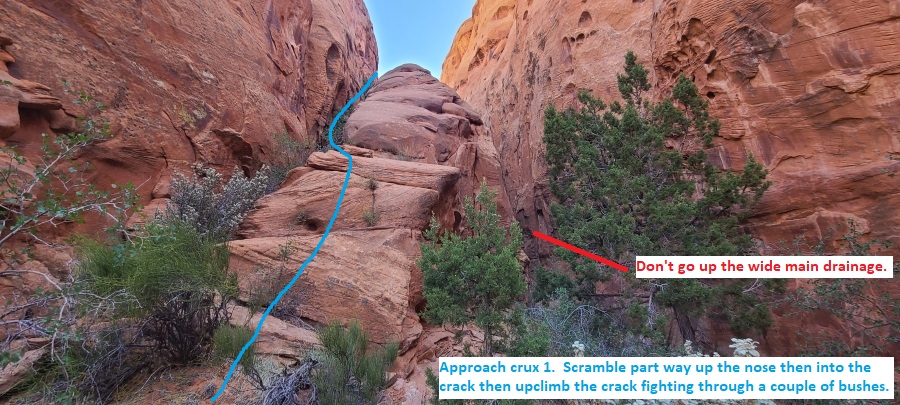
At the second fork
(Porkchop11Crx1) where
the main drainage hooks
left and travels up to
the north, look north up
the main fork to the
left then note a smaller
crack on the left
(west). Begin scrambling
up the slickrock nose
running up between the
smaller crack and the
main drainage. Shortly
up the slickrock nose
work your way into then
begin climbing up the
smaller crack fighting
through a couple bushes
as you go up. As the
crack tops out follow a
rolling ledge system for
about 150 feet to a
level vegetated spot.
From the brief level
vegetated spot
(Porkchop12), continue
north up the drainage
about 100 feet to
another level vegetated
spot with three cracks /
chutes at the north end.
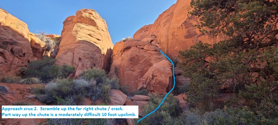
At the north end of this
small open vegetated
area (Porkchop13Crx2),
note 3 cracks / chutes
running up to the north.
Scramble up chute
farthest to the right
(east). Part way up the
chute is a stem style
upclimb of about 10 feet
with moderate difficulty
then becoming less steep
and easy to travel
again.
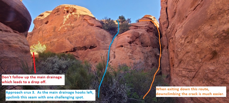
About 200 feet farther
north is a small open
vegetated area
(Porkchop14Crx3) where
the drainage hooks left
(west) and a deep crack
continuing up to the
north. Scramble about 20
feet up to a set of
bushes going up an
almost
vertical shallow seam
just left of the crack.
The scramble up is
moderately difficult but
the features are there.
Note: If using this
route as a return down
off the mesa, it will be
easier to downclimb the
crack to come down.
About 150 feet farther
continue north through
another small vegetated
valley (Porkchop15) and
up a rolling slickrock
ledge system.
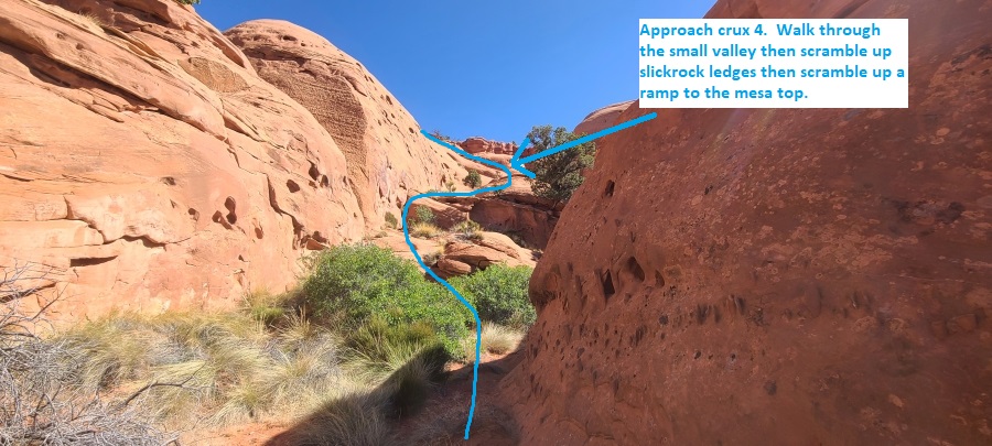
Near the top of the
ledge system turn left
and scramble west up a
steep slickrock ramp
(Porkchop16Crx4) for
about 80 feet to the top
of the ramp. This ramp
is smooth with few
features and will
require hands a feet for
a short distance to get
enough friction to go
up. If you look close
you may even see some
scrape marks from sheep
hooves as we did.
At the top of the steep
ramp (Porkchop17) the
route meets rolling
desert at the mesa top.
Route find southwest
along the mesa.
A little over 1000 feet
southwest the route
passes by a minor high
point (Porkchop18).
Continue southwest
staying up on the wide
crest of the mesa for
about 800 feet to a wide
almost un-noticed
saddle.
Wide almost un-noticed
saddle on the mesa
(Porkchop19). Continue
southwest and begin
veering right to contour
more west over toward
the rim of the wide open
upper portions of Pork
Chop.
About 0.25 miles farther
scramble and route find
down (Porkchop20) west
from the mesa top into
the open rolling
portions of Upper Pork
Chop.
About 400 feet farther
is the top of Pork Chop
Canyon (yPorkchopTp)
where several shallow
drainages begin to
merge.
The Canyoneering / Technical Section:
From the top of
Pork Chop Canyon (yPorkchopTp)
walk southwest down
canyon about 250 feet to
the first rap.
Rap 1 (dPorkchopR1)
anchored form a tree and
drops about 35 feet.
About 400 feet down
canyon is a short tight
crack (Porkchop21) to
stem through then
downclimb about 20 feet
in a tight crack.
About 100 feet farther
is another tight crack
(Porkchop22) to stem
through to a downclimb
of about 15 feet to the
top of a partner
assistable downclimb of
about 12 feet.
Immediately after is
more skinny slot to stem
where you will cross
over a deep pothole then
downclimb into a small
shallow pothole at the
top of the next rap.
Rap 2 (dPorkchopR2)
anchored using a
Sandtrap in a small
pothole and uses about
30 feet of rope with a
vertical drop of about
20 feet. There is little
sand at the rappel
itself so we farmed sand
from up canyon.
About 300 feet farther
the canyon makes a sharp
left where you scramble
down through an arch
(Porkchop23Arch) then
scramble down sloped
shallow potholes then a
steep crack to more
walking. This arch is a
cool surprise you come
around the corner to.
About 250 feet farther
is a downclimb
(Porkchop24) of about 15
feet down a vertical
tight crack.
About 600 feet farther
is a brief open spot
where forks join
(Porkchop25).
About 0.5 miles farther
is a short narrow crack
(Porkchop26) to
downclimb to then stem
over water. Optionally
you can bypass this slot
up and over on the RDC
side then walk back down
to the canyon floor
about 150 feet down
canyon.
About 500 feet farther
is the start of
(Porkchop27Slot) a 0.3
mile long slot section
of narrow canyon with
sculpted walls forcing a
mix of walking and
repeated up and down to
sections of galumphing.
Several spots we had
waist deep water but
recent rains would
create multiple spots to
swim. Most of the
stemming and galumphing
will be about 10 to 15
feet off the deck and
there are a few
downclimbs of about 10
feet.
As the narrow slot opens
(Porkchop28Open)
continue wash walking.
About 900 feet farther
is a short section
(Porkchop29) to scramble
down through with a log
at the end to downclimb
over or under.
A little more than 700
feet farther is a spot
where you can scramble
in and out of the canyon
(Porkchop30EE) on the
LDC (southeast) side.
About 150 feet farther
is a short downclimb
(Porkchop31) then a
short walk to a set of
long potholes to easily
bridge over.
About 200 feet farther
is one large and one
small horizontal arches
(Porkchop32Arch) to
climb down through or
bypass on the LDC side.
Shortly down canyon is a
short narrow section
with a couple short
downclimbs.
About 350 feet farther
is the start of
(Porkchop33Deep) a deep
section of canyon with
alcoves along a large
ledge system on the LDC
(south) side. You can
either partner assist a
drop of about 8 feet
then walk down canyon
about 200 feet to deep
slot or you can scramble
over to the large ledge
system on the LDC side
and check out the
alcoves as you walk the
ledge down canyon to the
next rap.
Rap 3 (dPorkchopR3)
anchored using a pack
drag and drops about 12
feet to a chamber with a
skinny slot exit. We had
tall people along and
were able to partner
assist this drop.
The skinny crack after
the rappel is tight and
forces you to stem up
about 5 feet then
downclimb the other side
of the skinny crack
where you will drop a
few feet down to a pool.
The pool was about waist
deep for us and had a
sloped but short exit
lip. If sand scours out
a partner assist or easy
pack toss may be needed
to get out. Just after
the pool is a narrow
slot about 80 feet long
to stem over or squeeze
down low before opening
up to more walking.
About 250 feet farther
down canyon is a
downclimb of about 8
feet by trees
(Porkchop34).
About 200 feet farther
is a short narrow
section of canyon
(Porkchop35) with a
couple of 5 foot
downclimbs to waist deep
pools that could be
swimmers if full.
About 200 feet farther
is a stem style
downclimb (Porkchop36)
of about 20 feet
stemming over a silo /
pothole on the way down.
The downclimb can be
done back to feet most
of the way down with the
last 4 feet a short drop
to a pool that can be a
swim if full but was
waist to chest deep for
us. At the other end of
the pool is the biggest
rappel in the canyon.
Rap 4 (dPorkchopR4)
anchored from a knot
chock about head high on
the LDC side and uses
about 70 feet of rope
with mostly free hanging
rappel on the way down.
Optionally a Watertrap
could be used. Another
option would use another
50 feet of rope to
scramble up to and
anchor from some trees
about 50 feet up.
Continuing down canyon
is easy walking with a
couple small drops to
scramble down or bypass
on small ledges.
About 700 feet farther
the canyon makes a sharp
left at a cross joint
(Porkchop37) and starts
into a deep, narrow and
beautiful section with a
few galumphs over a
couple skinny spots.
About 300 feet farther
is a partner assisted
downclimb (Porkchop38)
of about 10 feet
followed by a winding
downclimb of about 15
feet down a fluted slot
that winds down and
clockwise. The downward
winding fluted slot is a
very fun downclimb where
you need to stem out of
the flute to avoid a
pothole at the bottom.
A little over 500 feet
farther is the next rap.
Rap 5 (dPorkchopR5)
anchored from a log and
drops about 50 feet down
a very awkward skinny
slot. After rapping down
this rappel you are in
deep wide canyon with a
couple of large arches
down canyon. Walk down
canyon under the first
arch (Porkchop39Arch) then when you reach
the second arch
(Porkchop40Arch) scramble
up on the RDC side to
get on top of the arch
then scramble up the
arch to get to a large
ledge system. Going up
that arch is the start
of the exit from the
canyon.
Note:
Optionally it
is easier to avoid the
awkward rappel
altogether and from the
top of the rappel
scramble up to the large
ledge system on the LDC
((southeast) side. Once
on the ledge system walk
about 450 feet down
canyon to the the top of
the second arch. Leave
your pack on the large
ledge and scramble down
the arch into the canyon
and walk up canyon to
see the other arch and
the bottom of the
bypassed rappel.
The Exit:
From the
second large bridge
(Porkchop40Arch),
scramble up the top of
the arch to a large
ledge system to begin
the exit from the
canyon. To scramble up
out of the canyon,
scramble up the RDC side
to get onto the arch
them scramble up the
arch to get to the ledge
system above on the LDC
side. Or if you were on
the ledge system above
you could scramble down
into the canyon from
above. Under / down
canyon of the arch is a
drop of about 10 feet.
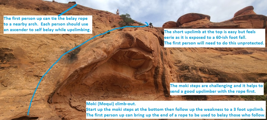
Once on the large ledge
system (Porkchop41),
walk southwest down
canyon passing a few
alcoves along the way.
About 0.25 miles
farther, still on the
ledge system, scramble
over a short section of
rock debris (Porkchop42)
then continue along the
wide ledge system.
About 900 feet farther
along the ledge system
is the bottom of the
moqui climb-out
(Porkchop43Clmb) near
the down canyon end of
the ledge system. The
first person up can drag
a rope up to then belay
those who follow by
tying the rope to a
nearby arch. At the
bottom is a set of moki
steps to climb up about
12 feet to a bush in a
weakness with bushes in
it. Once up into the
weakness, the rest of
the scramble is straight
forward and easy. At the
top of the climb-out is
a 4 foot upclimb /
mantle move that is easy
but eerie as it has
about 60 foot of
exposure. The first
person up will need to
do this unprotected as
they drag the rope up to
then belay those who
follow.
From the top out of the
moki climb-out go east
up the winding drainage.
About 200 feet up the
drainage contour around
and into this large
sandy depression
(Porkchop45) then
scramble up the east
side and route find a
short distance up to a
wide esplanade like
area.
Once up on the esplanade
area (Porkchop46), veer
left and travel up to
the north along very
easy walking on wide
open slickrock then
continue northeast
following a wide easy
sidewalk like area.
About 0.8 miles farther
is a small pinch
(Porkchop47) where you
are forced around a
point with little
walking room. As you
approach this spot it
appears it will not work
but it is easy and leads
to wide spaces on the
other side. Continue
northeast following the
wide sidewalk like area
and around the head of a
small side canyon about
500 feet away.
About 0.4 miles farther
contour around another
small drainage
(Porkchop48) and follow
easy flat slickrock west
for about 250 feet to
where the slickrock
starts to become more
rough and not as easy to
walk.
As the slickrock side
walk ends and the
terrain gets more rough
(Porkchop49), turn right
and walk northeast up to
the next higher level to
continue northeast with
easy travel but now in
dirt and rock terrain
and not open slickrock.
About 0.23 miles farther
scramble up a few short
ledges to the next
higher level
(Porkchop50) then
continue northeast and
contour up to another
section of slickrock
sidewalk continuing
north.
About 900 feet farther
as the slickrock
sidewalk ends
(Porkchop51), contour up
onto the mesa top.
Continue northeast along
the top of the wide dirt
mesa for about 1.5 miles
back to the wide almost
un-noticed saddle you
crossed on the approach
to the canyon.
Once back at the wide
almost un-noticed saddle
(Porkchop19) follow the
crest of the mesa
reversing your approach
route. About 600
feet north you will pass
over the same minor high
point as you did on the
approach.
From that minor high
point (Porkchop18)
follow northeast along
the mesa back to the top
of (Porkchop17) the same
steep ramp leading back
down to the same
sandstone loaves use for
the approach route up.
Reverse your route back
down through the loaves,
then follow the trail
wrapping around the base
of the cliff wall then
down the semi cairned
route and continue
reversing your approach
route back to the cars (pkPorkchop).
Downloadable GPX files
available at
BG-Gear Store
(easier than manual entry and a great way to support
Bluugnome).
Waypoint naming convention and map symbol information can be found on the Glossary page.
Elevations are approximate.
BEFORE
manually entering coordinates set your system to WGS84 datum and Lat/Lon hddd.ddddd° coordinate format.
Inconsistent datum's and coordinate formats will result in location errors.
Click to show / expand the list of waypoints below........
| Pork Chop (1) - Drive to Trailhead |
- exWolverine2
Lat/Lon (WGS84): N 37.86551
W -111.10404
Elev: NaN Feet
There are 2 exits for the Wolverine Loop Road off of the Burr Trail Road. This is the farthest southeast and is labeled on some maps as the Escalante Grand Staircase road 110 going south from here.
- exMoodyCyn
Lat/Lon (WGS84): N 37.77177
W -111.09247
Elev: 6,251 Feet
Exit off of the Wolverine Loop Road (road 110) to the Moody Canyon Road (road 116) goes off to the south.
- exSilverFalls
Lat/Lon (WGS84): N 37.73698
W -111.09086
Elev: NaN Feet
Exit off of Moody Canyon Road (road 116) where Silver Falls Road (road 117) goes off to the west.
- pkPorkchop
Lat/Lon (WGS84): N 37.71595
W -111.08618
Elev: 5,570 Feet
Small clearing on the east side of the road for a couple cars.
To follow the Porkchop Canyon route, walk west across the road walking rolling dessert where the occasional cairn may be found. Follow the cairned route leading to then up along the south side of a large gully.
|
| Pork Chop (2) - Approach |
- pkPorkchop
Lat/Lon (WGS84): N 37.71595
W -111.08618
Elev: 5,570 Feet
Small clearing on the east side of the road for a couple cars.
To follow the Porkchop Canyon route, walk west across the road walking rolling dessert where the occasional cairn may be found. Follow the cairned route leading to then up along the south side of a large gully.
- Porkchop01
Lat/Lon (WGS84): N 37.71483
W -111.09028
Elev: NaN Feet
Cairned route meets an old road. Turn right (north) and walk about 90 feet down the road to the apex of a turn crossing a small gully.
- Porkchop02
Lat/Lon (WGS84): N 37.71494
W -111.09053
Elev: NaN Feet
At the apex of this turn in the road, turn left and walk southwest away from the road up a small shallow gully which soon turns to a large shale stairway like path. Do not go northwest up the continuation of the larger gully.
- Porkchop03
Lat/Lon (WGS84): N 37.71473
W -111.09097
Elev: NaN Feet
As the shallow gully fades away and the slope gets little more gentle, continue up the slope to the west for another 250 feet to the top out of the hill.
- Porkchop04
Lat/Lon (WGS84): N 37.71451
W -111.09175
Elev: NaN Feet
When the hill tops out here, do not drop down the other side but instead turn right and contour north on mostly level terrain for about 225 feet to the crest of a wide ridge going up to the west.
- Porkchop05
Lat/Lon (WGS84): N 37.71505
W -111.09207
Elev: NaN Feet
Crest of a ridge going up to the west toward the base of the cliffs. Follow west up the ridge where you will soon find cairns and a faint path leading up the wide ridge toward the base of the cliffs above. The cairns marking the trail are intermittent and the trail is not yet well formed (May 2020) but taking your time to look will help keep you on an easy route up. Losing the trail here is rewarded with more effort in loose rock and dirt.
- Porkchop06
Lat/Lon (WGS84): N 37.71542
W -111.09584
Elev: 6,340 Feet
When the cairned route tops out and meets the base of the cliff wall here, turn left and follow well traveled use trails south along the base of the walls then slowly wrapping around west then northwest continuing along the base of the cliff wall.
Note: There are a lot of crack / splitter climbs with bolted belay stations at the top along this wall. A crack climber could spend many hours or days enjoying these.
- Porkchop07
Lat/Lon (WGS84): N 37.71547
W -111.09674
Elev: NaN Feet
As the trail around the base of the cliff briefly fades here continue northwest following the base of the wall. Each time you think you may have lost the trail, scramble up to the base of the cliff wall to find the trail again. Do not stray too far from the base of the wall or you will lose the trail.
- Porkchop08
Lat/Lon (WGS84): N 37.71611
W -111.09715
Elev: NaN Feet
Trail goes behind a large arch.
- Porkchop09
Lat/Lon (WGS84): N 37.71679
W -111.09811
Elev: NaN Feet
As the trail along the base of the cliff dumps into a large drainage here, continue north up the drainage about 300 feet to a large fork.
- Porkchop10
Lat/Lon (WGS84): N 37.71756
W -111.09769
Elev: NaN Feet
Stay right at this large fork walking northeast for about 100 feet to a second fork.
- Porkchop11Crx1
Lat/Lon (WGS84): N 37.71767
W -111.09738
Elev: NaN Feet
At this second fork where the main drainage hooks left and travels up to the north, look north up the main fork to the left then note a smaller crack on the left (west). Begin scrambling up the slickrock nose running up between the smaller crack and the main drainage. Shortly up the slickrock nose work your way into then begin climbing up the smaller crack fighting through a couple bushes as you go up. As the crack tops out follow a rolling ledge system for about 150 feet to a level vegetated spot.
- Porkchop12
Lat/Lon (WGS84): N 37.71831
W -111.09729
Elev: NaN Feet
From this brief level vegetated spot, continue north up the drainage about 100 feet to another level vegetated spot with three cracks / chutes at the north end.
- Porkchop13Crx2
Lat/Lon (WGS84): N 37.71861
W -111.09733
Elev: NaN Feet
At the north end of this small open vegetated area, note 3 cracks / chutes running up to the north. Scramble up chute farthest to the right (east). Part way up the chute is a stem style upclimb of about 10 feet with moderate difficulty then becoming less steep and easy to travel again.
- Porkchop14Crx3
Lat/Lon (WGS84): N 37.71918
W -111.09737
Elev: NaN Feet
Small open vegetated area where the drainage hooks left (west) and a deep crack continuing up to the north. Scramble about 20 feet up to a set of bushes going up an almost vertical shallow seam just left of the crack.. The scramble up is moderately difficult but the features are there. Continue north about 150 feet to a small vegetated valley.
Note: If using this route as a return down off the mesa, it will be easier to downclimb the crack to come down.
- Porkchop15
Lat/Lon (WGS84): N 37.71970
W -111.09726
Elev: NaN Feet
Continue north through this small vegetated valley and up a rolling slickrock ledge system.
- Porkchop16Crx4
Lat/Lon (WGS84): N 37.72050
W -111.09720
Elev: NaN Feet
Near the top of the ledge system turn left and scramble west up a steep slickrock ramp for about 80 feet to the top of the ramp. This ramp is smooth with few features and will require hands a feet for a short distance to get enough friction to go up. If you look close you may even see some scrape marks from sheep hooves as we did.
- Porkchop17
Lat/Lon (WGS84): N 37.72044
W -111.09749
Elev: 6,565 Feet
Top of steep slickrock ramp the route meets rolling desert at the mesa top. Route find southwest along the mesa.
- Porkchop18
Lat/Lon (WGS84): N 37.71864
W -111.10070
Elev: 6,590 Feet
Route passes by a minor high point. Continue southwest staying up on the wide crest of the mesa for about 800 feet to a wide almost un-noticed saddle.
- Porkchop19
Lat/Lon (WGS84): N 37.71693
W -111.10174
Elev: NaN Feet
Wide almost un-noticed saddle on the mesa. To go to the top of Pork Chop, continue southwest and begin veering right to contour more west over toward the rim of the wide open upper portions of Pork Chop.
When exiting from Pork Chop, follow the crest of the mesa reversing your route over to then down through the slickrock loaves.
- Porkchop20
Lat/Lon (WGS84): N 37.71571
W -111.10608
Elev: NaN Feet
Scramble and route find down west from the mesa top into the open rolling portions of Upper Pork Chop.
- yPorkchopTp
Lat/Lon (WGS84): N 37.71581
W -111.10764
Elev: 6,360 Feet
Top of Pork Chop Canyon where several shallow drainages begin to merge. Walk southwest down Pork Chop.
|
| Pork Chop (3) - The Canyon |
- yPorkchopTp
Lat/Lon (WGS84): N 37.71581
W -111.10764
Elev: 6,360 Feet
Top of Pork Chop Canyon where several shallow drainages begin to merge. Walk southwest down Pork Chop.
- dPorkchopR1
Lat/Lon (WGS84): N 37.71530
W -111.10824
Elev: NaN Feet
Rap1 - Pork Chop. Anchored form a tree and drops about 35 feet.
- Porkchop21
Lat/Lon (WGS84): N 37.71478
W -111.10945
Elev: NaN Feet
Short tight crack to stem through then downclimb about 20 feet in a tight crack.
- Porkchop22
Lat/Lon (WGS84): N 37.71461
W -111.10976
Elev: NaN Feet
Another tight crack to stem through to a downclimb of about 15 feet to the top of a partner assistable downclimb of about 12 feet. Immediately after is more skinny slot to stem where you will cross over a deep pothole then downclimb into a small shallow pothole at the top of the next rap.
- dPorkchopR2
Lat/Lon (WGS84): N 37.71454
W -111.10991
Elev: NaN Feet
Rap 2 - Pork Chop. Anchored using a sandtrap in a small pothole and uses about 30 feet of rope with a vertical drop of about 20 feet. There is little sand at the rappel itself so we farmed sand from up canyon.
- Porkchop23Arch
Lat/Lon (WGS84): N 37.71421
W -111.11076
Elev: NaN Feet
Canyon makes a sharp left where you scramble down through an arch then scramble down sloped shallow potholes then a steep crack to more walking. This arch is a cool surprise you come around the corner to.
- Porkchop24
Lat/Lon (WGS84): N 37.71361
W -111.11124
Elev: NaN Feet
Downclimb of about 15 feet down a vertical tight crack.
- Porkchop25
Lat/Lon (WGS84): N 37.71372
W -111.11311
Elev: NaN Feet
Brief open spot where forks join.
- Porkchop26
Lat/Lon (WGS84): N 37.70919
W -111.11875
Elev: NaN Feet
Short narrow crack to downclimb to then stem over water. Optionally you can bypass this slot up and over on the RDC side then walk back down to the canyon floor about 150 feet down canyon.
- Porkchop27Slot
Lat/Lon (WGS84): N 37.70830
W -111.12046
Elev: 6,035 Feet
Start of a 0.3 mile long slot section of narrow canyon with sculpted walls forcing a mix of walking and repeated going up a few feet to galumph. Several spots we had waist deep water but recent rains would create multiple spots to swim. Most of the stemming and galumphing will be about 10 to 15 feet off the deck and there are a few downclimbs of about 10 feet.
- Porkchop28Open
Lat/Lon (WGS84): N 37.70591
W -111.12421
Elev: NaN Feet
Narrow slot ends with open wash walking.
- Porkchop29
Lat/Lon (WGS84): N 37.70434
W -111.12648
Elev: NaN Feet
Short section to scramble down through with a log at the end to downclimb over or under.
- Porkchop30EE
Lat/Lon (WGS84): N 37.70293
W -111.12842
Elev: NaN Feet
Can scramble in and out of the canyon on the LDC (southeast) side.
- Porkchop31
Lat/Lon (WGS84): N 37.70255
W -111.12868
Elev: NaN Feet
Short downclimb then a short walk to a set of long potholes to easily bridge over.
- Porkchop32Arch
Lat/Lon (WGS84): N 37.70216
W -111.12912
Elev: NaN Feet
One large and one small horizontal arches to climb down through or bypass on the LDC side. Shortly down canyon is a short narrow section with a couple short downclimbs.
- Porkchop33Deep
Lat/Lon (WGS84): N 37.70134
W -111.12995
Elev: NaN Feet
Start of a deep section of canyon with alcoves along a large ledge system on the LDC (south) side. You can either partner assist a drop of about 8 feet then walk down canyon about 200 feet to deep slot or you can scramble over to the large ledge system on the LDC side and check out the alcoves as you walk the ledge down canyon.
- dPorkchopR3
Lat/Lon (WGS84): N 37.70106
W -111.13039
Elev: NaN Feet
Rap 3 - Pork Chop. Anchored using a pack drag and drops about 12 feet to a chamber with a skinny slot exit. We had tall people along and were able to partner assist this drop.
The skinny crack after the rappel is tight and forces you to stem up about 5 feet then downclimb the other side of the skinny crack where you will drop a few feet down to a pool. The pool was about waist deep for us and had a sloped but short exit lip. If sand scours out a partner assist or easy pack toss may be needed to get out. Just after the pool is a narrow slot about 80 feet long to stem over or squeeze down low before opening up to more walking.
- Porkchop34
Lat/Lon (WGS84): N 37.70036
W -111.13131
Elev: NaN Feet
Downclimb of about 8 feet by trees.
- Porkchop35
Lat/Lon (WGS84): N 37.69978
W -111.13160
Elev: NaN Feet
Short narrow section of canyon with a couple of 5 foot downclimbs to waist deep pools that could be swimmers if full.
- Porkchop36
Lat/Lon (WGS84): N 37.69947
W -111.13217
Elev: NaN Feet
Stem style downclimb of about 20 feet stemming over a silo / pothole on the way down. The downclimb can be done back to feet most of the way down with the last 4 feet a short drop to a pool that can be a swim if full but was waist to chest deep for us. At the other end of the pool is the biggest rappel in the canyon.
- dPorkchopR4
Lat/Lon (WGS84): N 37.69948
W -111.13238
Elev: NaN Feet
Rap 4 - Pork Chop. Anchored from a knot chock about head high on the LDC side and uses about 70 feet of rope with mostly free hanging rappel on the way down. Optionally a Watertrap could be used. Another option would use another 50 feet of rope to scramble up to and anchor from some trees about 50 feet up. Continuing down canyon is easy walking with a couple small drops to scramble down or bypass on small ledges.
- Porkchop37
Lat/Lon (WGS84): N 37.69833
W -111.13434
Elev: NaN Feet
Canyon makes a sharp left at a cross joint and starts into a deep, narrow and beautiful section with a few galumphs over a couple skinny spots.
- Porkchop38
Lat/Lon (WGS84): N 37.69753
W -111.13459
Elev: NaN Feet
Partner assisted downclimb of about 10 feet followed by a winding downclimb of about 15 feet down a fluted slot that winds down and clockwise. The downward winding fluted slot is a very fun downclimb where you need to stem out of the flute to avoid a pothole at the bottom.
- dPorkchopR5
Lat/Lon (WGS84): N 37.69729
W -111.13489
Elev: NaN Feet
Rap 5 - Porkchop. Anchored from a log and drops about 50 feet down a very awkward skinny slot. After rapping down this rappel you are in deep wide canyon with a couple of large arches down canyon. Walk down canyon under the first arch then when you reach the second arch scramble up on the RDC side to get on top of the arch then scramble up the arch to get to a large ledge system. Going up that arch is the start of the exit from the canyon.
Optionally it is easier to avoid the awkward rappel altogether and from the top of the rappel scramble up to the large ledge system on the LDC ((southeast) side. Once on the ledge system walk about 450 feet down canyon to the the top of the second arch. Leave your pack on the large ledge and scramble down the arch into the canyon and walk up canyon to see the other arch and the bottom of the bypassed rappel.
- Porkchop39Arch
Lat/Lon (WGS84): N 37.69643
W -111.13530
Elev: NaN Feet
Large bridge / arch to walk under on the canyon floor.
- Porkchop40Arch
Lat/Lon (WGS84): N 37.69622
W -111.13540
Elev: 5,660 Feet
Second large bridge that you can scramble up the top of the arch to a large ledge system to begin the exit from the canyon. To scramble up out of the canyon, scramble up the RDC side to get onto the arch them scramble up the arch to get to the ledge system above on the LDC side. Or if you were on the ledge system above you could scramble down into the canyon from above. Under / down canyon of the arch is a drop of about 10 feet.
|
| Pork Chop (4) - Exit |
- Porkchop40Arch
Lat/Lon (WGS84): N 37.69622
W -111.13540
Elev: 5,660 Feet
Second large bridge that you can scramble up the top of the arch to a large ledge system to begin the exit from the canyon. To scramble up out of the canyon, scramble up the RDC side to get onto the arch them scramble up the arch to get to the ledge system above on the LDC side. Or if you were on the ledge system above you could scramble down into the canyon from above. Under / down canyon of the arch is a drop of about 10 feet.
- Porkchop41
Lat/Lon (WGS84): N 37.69610
W -111.13508
Elev: NaN Feet
Once on this LDC ledge system, walk southwest down canyon passing a few alcoves along the way.
- Porkchop42
Lat/Lon (WGS84): N 37.69338
W -111.13849
Elev: NaN Feet
Scramble over a short section of rock debris then continue along the wide ledge system.
- Porkchop43Clmb
Lat/Lon (WGS84): N 37.69137
W -111.14009
Elev: NaN Feet
Bottom of the moqui climb-out near the down canyon end of the ledge system. The first person up can drag a rope up to then belay those who follow by tying the rope to a nearby arch. At the bottom is a set of moki steps to climb up about 12 feet to a bush in a weakness with bushes in it. Once up into the weakness, the rest of the scramble is straight forward and easy. At the top of the climb-out is a 4 foot upclimb / mantle move that is easy but eerie as it has about 60 foot of exposure. The first person up will need to do this unprotected as they drag the rope up to then belay those who follow.
- Porkchop44
Lat/Lon (WGS84): N 37.69126
W -111.13991
Elev: NaN Feet
Top out of the moki climb-out where the first person up can set the belay rope from a nearby arch to assist those who follow up. Once at the top go east up the winding drainage.
- Porkchop45
Lat/Lon (WGS84): N 37.69113
W -111.13935
Elev: NaN Feet
Contour around and into this large sandy depression then scramble up the east side and route find a short distance up to a wide esplanade like area.
- Porkchop46
Lat/Lon (WGS84): N 37.69109
W -111.13894
Elev: NaN Feet
Once up on the esplanade area, veer left and travel up to the north along very easy walking on wide open slickrock then continue northeast following a wide easy sidewalk like area.
- Porkchop48
Lat/Lon (WGS84): N 37.70254
W -111.12581
Elev: NaN Feet
Contour around another small drainage and follow easy flat slickrock west for about 250 feet to where the slickrock starts to become more rough and not as easy to walk.
- Porkchop49
Lat/Lon (WGS84): N 37.70291
W -111.12658
Elev: NaN Feet
Slickrock side walk ends and the terrain gets more rough. Turn right and walk northeast up to the next higher level to continue northeast with easy travel but now in dirt and rock terrain and not open slickrock.
- Porkchop50
Lat/Lon (WGS84): N 37.70501
W -111.12334
Elev: NaN Feet
Scramble up a few short ledges to the next higher level then continue northeast and contour up to another section of slickrock sidewalk continuing north.
- Porkchop51
Lat/Lon (WGS84): N 37.70617
W -111.12025
Elev: 6,200 Feet
As the slickrock sidewalk ends, contour up onto the mesa top here. Continue northeast along the top of the wide dirt mesa for about 1.5 miles back to the wide almost un-noticed saddle you crossed on the approach to the canyon.
- Porkchop19
Lat/Lon (WGS84): N 37.71693
W -111.10174
Elev: NaN Feet
Wide almost un-noticed saddle on the mesa. To go to the top of Pork Chop, continue southwest and begin veering right to contour more west over toward the rim of the wide open upper portions of Pork Chop.
When exiting from Pork Chop, follow the crest of the mesa reversing your route over to then down through the slickrock loaves.
- Porkchop18
Lat/Lon (WGS84): N 37.71864
W -111.10070
Elev: 6,590 Feet
Route passes by a minor high point. Continue southwest staying up on the wide crest of the mesa for about 800 feet to a wide almost un-noticed saddle.
- Porkchop17
Lat/Lon (WGS84): N 37.72044
W -111.09749
Elev: 6,565 Feet
Top of steep slickrock ramp the route meets rolling desert at the mesa top. Route find southwest along the mesa.
- Porkchop16Crx4
Lat/Lon (WGS84): N 37.72050
W -111.09720
Elev: NaN Feet
Near the top of the ledge system turn left and scramble west up a steep slickrock ramp for about 80 feet to the top of the ramp. This ramp is smooth with few features and will require hands a feet for a short distance to get enough friction to go up. If you look close you may even see some scrape marks from sheep hooves as we did.
- Porkchop15
Lat/Lon (WGS84): N 37.71970
W -111.09726
Elev: NaN Feet
Continue north through this small vegetated valley and up a rolling slickrock ledge system.
- Porkchop14Crx3
Lat/Lon (WGS84): N 37.71918
W -111.09737
Elev: NaN Feet
Small open vegetated area where the drainage hooks left (west) and a deep crack continuing up to the north. Scramble about 20 feet up to a set of bushes going up an almost vertical shallow seam just left of the crack.. The scramble up is moderately difficult but the features are there. Continue north about 150 feet to a small vegetated valley.
Note: If using this route as a return down off the mesa, it will be easier to downclimb the crack to come down.
- Porkchop13Crx2
Lat/Lon (WGS84): N 37.71861
W -111.09733
Elev: NaN Feet
At the north end of this small open vegetated area, note 3 cracks / chutes running up to the north. Scramble up chute farthest to the right (east). Part way up the chute is a stem style upclimb of about 10 feet with moderate difficulty then becoming less steep and easy to travel again.
- Porkchop12
Lat/Lon (WGS84): N 37.71831
W -111.09729
Elev: NaN Feet
From this brief level vegetated spot, continue north up the drainage about 100 feet to another level vegetated spot with three cracks / chutes at the north end.
- Porkchop11Crx1
Lat/Lon (WGS84): N 37.71767
W -111.09738
Elev: NaN Feet
At this second fork where the main drainage hooks left and travels up to the north, look north up the main fork to the left then note a smaller crack on the left (west). Begin scrambling up the slickrock nose running up between the smaller crack and the main drainage. Shortly up the slickrock nose work your way into then begin climbing up the smaller crack fighting through a couple bushes as you go up. As the crack tops out follow a rolling ledge system for about 150 feet to a level vegetated spot.
- Porkchop10
Lat/Lon (WGS84): N 37.71756
W -111.09769
Elev: NaN Feet
Stay right at this large fork walking northeast for about 100 feet to a second fork.
- Porkchop09
Lat/Lon (WGS84): N 37.71679
W -111.09811
Elev: NaN Feet
As the trail along the base of the cliff dumps into a large drainage here, continue north up the drainage about 300 feet to a large fork.
- Porkchop08
Lat/Lon (WGS84): N 37.71611
W -111.09715
Elev: NaN Feet
Trail goes behind a large arch.
- Porkchop07
Lat/Lon (WGS84): N 37.71547
W -111.09674
Elev: NaN Feet
As the trail around the base of the cliff briefly fades here continue northwest following the base of the wall. Each time you think you may have lost the trail, scramble up to the base of the cliff wall to find the trail again. Do not stray too far from the base of the wall or you will lose the trail.
- Porkchop06
Lat/Lon (WGS84): N 37.71542
W -111.09584
Elev: 6,340 Feet
When the cairned route tops out and meets the base of the cliff wall here, turn left and follow well traveled use trails south along the base of the walls then slowly wrapping around west then northwest continuing along the base of the cliff wall.
Note: There are a lot of crack / splitter climbs with bolted belay stations at the top along this wall. A crack climber could spend many hours or days enjoying these.
- Porkchop05
Lat/Lon (WGS84): N 37.71505
W -111.09207
Elev: NaN Feet
Crest of a ridge going up to the west toward the base of the cliffs. Follow west up the ridge where you will soon find cairns and a faint path leading up the wide ridge toward the base of the cliffs above. The cairns marking the trail are intermittent and the trail is not yet well formed (May 2020) but taking your time to look will help keep you on an easy route up. Losing the trail here is rewarded with more effort in loose rock and dirt.
- Porkchop04
Lat/Lon (WGS84): N 37.71451
W -111.09175
Elev: NaN Feet
When the hill tops out here, do not drop down the other side but instead turn right and contour north on mostly level terrain for about 225 feet to the crest of a wide ridge going up to the west.
- Porkchop03
Lat/Lon (WGS84): N 37.71473
W -111.09097
Elev: NaN Feet
As the shallow gully fades away and the slope gets little more gentle, continue up the slope to the west for another 250 feet to the top out of the hill.
- Porkchop02
Lat/Lon (WGS84): N 37.71494
W -111.09053
Elev: NaN Feet
At the apex of this turn in the road, turn left and walk southwest away from the road up a small shallow gully which soon turns to a large shale stairway like path. Do not go northwest up the continuation of the larger gully.
- Porkchop01
Lat/Lon (WGS84): N 37.71483
W -111.09028
Elev: NaN Feet
Cairned route meets an old road. Turn right (north) and walk about 90 feet down the road to the apex of a turn crossing a small gully.
- pkPorkchop
Lat/Lon (WGS84): N 37.71595
W -111.08618
Elev: 5,570 Feet
Small clearing on the east side of the road for a couple cars.
To follow the Porkchop Canyon route, walk west across the road walking rolling dessert where the occasional cairn may be found. Follow the cairned route leading to then up along the south side of a large gully.
|