Canyoneering Route Description
DDI Canyon - 4A(B) IV (X)
Escalante National Monument, Utah.
10-26-14, 5 people, 1 Day (Travel time in route 9.5 hours)

03-30-19, 6 people, 1 Day (Travel time in route 9.25 hours) Time
includes the group splitting to do different forks
Time Required - 8 to 11 hours
Distance - 6.5 miles Total, 0.7 miles Technical
Rappels - 4 Rappels, Longest Rappel 85 feet.
Elevation Range - 4600 - 4140 Feet
Shuttle Required - No Vehicle - High Clearance, 4WD if bad road conditions
Permit Required - No
Rappelling and anchor gear, Ropes and or pull cords for rappels up
to 85 feet and 50 feet of 1 inch webbing for sling placement.
Potshots just in case. Wet
suits not needed if weather window is planned right, see notes in
general comments. On of the anchors may need a significant
amount of webbing to extend which is why the recommendation for so
much webbing.
DDI is work and does come with risk but a very cool place
and well worth the visit. I remember as soon as we exited after the first trip,
I said "I would definitely do that one again! Not right away but I would like to
go back".
WARNING!! This is an X Canyon:
There are
potentially deadly situations with no way to add protection. When that
happens, friends or gear are of no use... You truly are "on your own" (with
an audience). Do not attempt an X canyon until you are proficient with
sustained high stemming and confident with your technical abilities
including advanced anchors, ascending, pot hole escape and partner assists.
Information about X canyons is of little use if you lack skills or
experience. Making a mistake at the wrong time can kill. Drop into an X
canyon.... "At Your Own Risk". Ultimately you are responsible for your
own actions.
Everyone in our group ran out of water so be sure to
bring a little more than you think you will need.
The A(B) water rating is due to there being water in
the lower canyon but hauling wetsuits would be a lot of work. Best to
plan on the water and plan your weather window accordingly. See more
notes below.
The approach route up out of Coyote Gulch and to the
top of DDI is over convoluted but forgiving to travel over rolling slickrock
with few obvious landmarks. A GPS or good map navigation skills helpful here
as there are no obvious landmarks to navigate by.
Note:
There is an upper slot about
1000 feet long that is above the entry described here that we did not do.
After walking up along the RDC rim then down along the LDC rim we do not
feel it worth dropping into this part. Overall it looks shallow with
multiple small silos. It looks like there may be some partner assists and
minor rope work but overall looks like it may be best to spend time enjoying
the main DDI slot down canyon of this slot. The drop in we used and
described here was to rap from a tree in a sandy gully skipping about 100
feet of large potholes.
Once in the canyon below rap 1 from the rim, it is
stemming all the way to rap 2 except for a couple short spots to go to the
ground. After rap 2 is about 200 feet of strenuous stemming before a walking
section down to rap 3. The last 200 feet of canyon between raps 3 and 4 is
more deep slot with twisting walls and a few skinny spots to go up and over.
One spot you need to go high for about 50 feet down canyon then shimmy down
a tight crack to a pothole that will be a swimmer with a skinny exit that is
difficult to climb out of and will likely require partner assist.
Immediately following is a very awkward 8 foot downclimb into another
swimmer pothole also requiring a partner assist. Rap 4 is very awkward due
to it being in a very tight slot and anchored from a chokestone in the
skinny crack below your feet. It may be a good idea to have a leash clipped
to the rope allowing you to pull the rope up from your feet.
There is unavoidable poison ivy at the bottom of the
last rap that you rap down into. The exit is down wide canyon with super
tall walls while trying to avoid dense sections of poison ivy, pools of
water and grass so thick that you can never tell when you will step into a
waist deep water hole. The vegetation is so thick there are times you are
not walking on ground, but instead on the vegetation itself with the
occasional thin spot you fall into. Oh yeah its super pretty too. I really
enjoyed the exit as it was fun, controlled madness. Not everyone felt as
happy about this section as I did though.
Wet suits and weather:
Dragging a wetsuit through DDI would add a lot of work to the day and not
worth it. Plan DDI for cool days so stemming is not too exhausting but not
cold days where the water could be a danger in the final slot. Our first
visit the weather forcast called for lows of mid 40's and highs for mid
70's, and we all felt it was a good weather window. Our second visit had
lows in the upper 40's and highs in the upper 50's and we were very cold in
the final potholes and all felt it was way too cold in there.
Note:
There is a side slot on the LDC (southeast) side of DDI that leads down into
DDI just above DDI rap2. We went and checked this out and found it to be
totally downclimable down into DDI just above DDI rap 2. The side slot is
short and not worth the effort to go over to it. Time is much better spent
enjoying the upper part of DDI proper.
To get to the Trailhead
From the city of Escalante drive about 4 miles southeast on Hwy
12 to the turn off for Hole-In-The-Rock road on the right (extHoleInRock). The condition
of the dirt Hole in the Rock road
varies
a lot with recent rains and road maintenance. High clearance
may be needed in extreme cases but most of the time passenger
cars will be fine for the first 30 or 40 miles on Hole in the
Rock road.
Travel about 31.9 miles southeast on
Hole-In-The-Rock road to the turn off for Chimney Rock (exChimneyRk).
Turn left (northeast) onto Chimney Rock Road and drive about 1.9
miles to a sharp left turn in the road (CimneyRk02).
Follow the sharp turn left to drive east. Beyond this
sharp left turn (CimneyRk02) the road has a lot of deep sand.
High clearance / 4WD is recommended.
About 0.7 miles farther is Chimney Rock and a place to park a
few vehicles (ChimneyRock). This is also where the deep
sand ends.
Continue past Chimney Rock for about 1 mile to the end of the
road to park (pkChimCoyoteA).
To leave the Exit Vehicle / Escape Pod
No exit vehicle is needed. This is done as an out and back
route.
GPS coordinate information listed at the bottom. For information about waypoint naming and map symbols, refer to the
Glossary page.

Click the links for maps of the route.
Map of the drive into the route.
Map of the last part of the drive into the route.
Map of the entire route and first part of approach.
Map of the last part of the approach.
Map of the technical section.
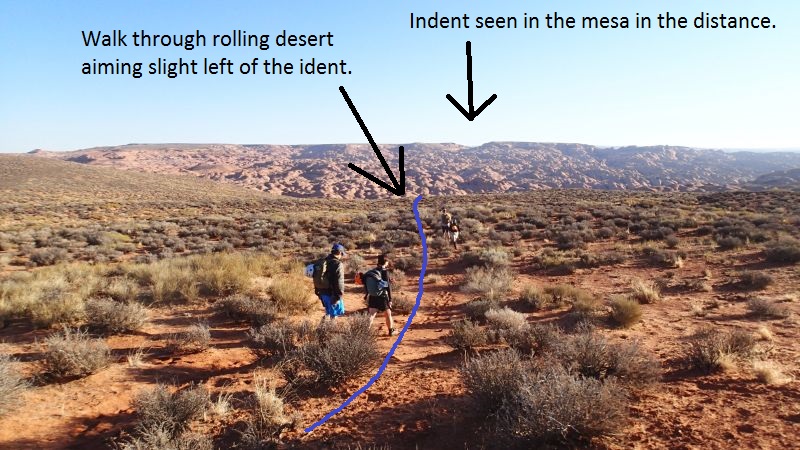
The Approach:
From the parking area (pkChimCoyoteA)
walk northeast toward
the indent seen on the
mesa in the distance.
Aim slight left (west)
of the indent. Walk
through rolling dirt
desert about 0.6 miles
to where the dirt begins
to extend out into
slickrock.
When the dirt begins to
extend out into
slickrock (ChimCoyote11)
continue northeast about
400 feet and starting to
contour down the left
(west) side of the dirt
toward a small short
shallow slot about 400
feet away.
From the top of the
small short shallow slot
(ChimCoyote12) walk
around on the left
(west) side. The route
down into Coyote Gulch
from here will roughly
follow down along the
left (west) side of this
side drainage. Continue
northeast route finding
your way down rolling
slickrock for about 900
feet as you bypass
another slot in this
drainage about 400 feet
long.
After bypassing and
getting to the lower end
(ChimCoyote13) of 400
foot long slot, continue
northeast route finding
your way along rolling
slickrock about 900 feet
to where dirt slopes
lead down into Coyote
Gulch.
From the top of the dirt
slopes (ChimCoyote14)
follow one of many use
trails down into Coyote
Gulch about 200 feet
northeast.
Once down in Coyote
Gulch (jCyoteChimny1)
turn right and walk east
down Coyote Gulch
passing a gate on the
right about 500 feet
down the creek.
Continue down east
Coyote Gulch for about
0.6 miles to the apex of
a sharp turn in Coyote
Gulch (jBigTonyExt).
stay in Coyote Gulch
traveling down to the
east.
About 600 feet
farther leave Coyote
Gulch at the apex of
bend (jDDI-UpTo) and
follow use trails north
up steep dirt which soon
turns to a wide
slickrock ridge.
As you go up the ridge
veer right making your
way into the bottom of a
trough about 400 feet
away.
Follow up the trough to
the north (DDI-01).
About 275 feet farther
the trough tops out
(DDI-02). Continue north
up sloped slickrock for
about 1000 feet to cross
over a drainage just
above a series of
potholes.
As the route crosses
over the drainage just
above (DDI-03) a series
of potholes where the
drainage makes a bend.
Cross over at the bend
and veer right and walk
northeast following up
along the right (east)
side of the drainage.
Continue northeast for
about 0.5 miles until
you get to the rim of
DDI. The terrain is
convoluted rolling
slickrock but very
forgiving and easy to
route find.
When the route meets the
rim of DDI (DDI-04) you
have views down into the
canyon where you can see
how deep it is deep.
Veer left and route find
north along the rim of
DDI.
About 0.2 miles farther
is a spot on the rim of
DDI overlooking (DDI-05)
a fork in the canyon.
Follow the rim of the
left fork for about 550
feet to where you can
cross over the shallow
upper end of the fork.
About 550 feet farther
the route crosses over
(DDI-06) the shallow
portion of the left fork
where you then veer
right and go a little
over 500 feet to where
you can drop into DDI.
About 500 feet farther
and just before reaching
the top of DDI is a
small dome (DDI-07)
where you can scramble
down into the sandy
gully leading down into
DDI then rap from a tree
down to the canyon
floor.
Note:
From this dome you
can see there is an
upper slot above this
standard drop in about
1000 feet long with
multiple silos. The
upper slot is not very
deep has a different
character than the lower
portion of the canyon.
Turn left and walk east
down along this sandy
gully to the tree
(dDDI-R1) for the rap in
by the head of DDI
(yDDI-Tp).
The Canyoneering / Technical Section:
Instead of
scrambling down to the
canyon floor at the head
of DDI (yDDI-Tp), rappel
from the tree on the LDC
(west) side skipping
about 100 feet of
potholes.
Rap 1 (dDDI-R1) anchored
from a small tree on the
rim in a sand filled
gully and uses about 85
feet of rope to the
canyon floor. This drop
in point is just below a
100 foot long section
with multiple potholes.
Note:
Do not use a 65 foot
rope for this drop or
you will need to get off
rope in the stemmed
position, pull the ropes
then stem down to the
canyon floor. Ask me how
I know this.
After getting down rap 1
from the rim,
immediately begin
stemming down canyon at
heights ranging from 10
to 35 feet off the deck
for about 300 feet to a
short section of ground
walking. The walls are
deep sculpted and
pretty.
When you hit the ground
(DDI07GrndSrt) just
before a right hand bend
you can walk on the
ground for about 300
feet to where the walls
pinch down forcing you
up again (DDI08GrndEnd).
When forced up again
(DDI08GrndEnd) the
stemming is relatively
straight forward with
mostly well featured
walls and the occasional
undulation or semi
gaping feature to cross.
Stemming continues for
about 650 feet down to a
fork dropping in on the
RDC (northwest) side.
When the fork comes in
(DDI09Fork) from the RDC
(northwest) side, the
canyon changes character
to more twisted winding
sculpted walls where
movement requires
noticeably more work
trying to figure out how
move between the walls
while stemming, route
finding up and down and
moving over a few more
semi wide gaping spots.
About 800 feet down
canyon is a spot where
you can very briefly go
to the ground.
At the spot where you
very briefly go to the
ground (DDI10GrndBrief)
and then go back up, the
stemming continues at
heights up to 35 feet.
About 250 feet farther
the canyon makes a
sweeping left hand bend.
As the canyon goes
around a left hand bend
(DDI11), continue
stemming up to 30 feet
off the deck as the
canyon starts turning to
more of a v-slot galumph
style of travel and for
the first time in a few
hours you are out in
sunlight.
A little over 200 feet
farther the route drops
down to the ground where
a cross joint drops in
on the LDC (east) side
(DDI12GrndJoint) and you
can walk down to rap 2.
Note:
We have dropped into
DDI here once to check
out that cross joint and
found it not that
exciting and fully downclimbable down
into DDI.
Rap 2 (dDDI-R2) anchored
RDC from rocks in a
cross joint and drops
about 20 feet.
The next almost 200 feet
of canyon down to
another cross joint is a
lot of work as the shape
of the walls forces you
up and down over and
over sometimes trying to
stem through tight spots
or bridge over a couple
moderately wide silos.
As the canyon makes a
right hand bend as a
cross joint comes in on
the left (DDI13Joint),
you you can begin to
drop to the ground then
begin walking down
canyon where there will
likely always be shin to
thigh deep water to
wade. There is one short
skinny spot you will
need to stem up about 15
feet and galumph down
canyon to go over.
About 500 feet farther
is rap 3.
Rap 3 (dDDI-R3) uses
about 60 feet of rope,
anchored from an arch
about 25 feet back and
drops over two stages of
about 15 feet then 15
feet to a deep pool.
Down canyon is more deep
slot with twisting walls
and a few skinny spots
to go up and over. One
spot you need to go high
for about 50 feet down
canyon then shimmy down
a tight crack to pothole
with a skinny exit
difficult to climb out
of exit which will
likely require partner
assist. Then an awkward
8 foot downclimb to
another pothole that is
very awkward also
requiring a partner
assist.
Rap 4 (dDDI-R4) anchored
from a choke stone down
in a deep narrow crack
and drops about 35 feet
to wide open canyon into
a patch of poison ivy.
The crack leading to the
final rap is very skinny
and very awkward to
squeeze through to get
out to where you can
rappel out of the crack.
It may be a good idea to
have a leash clipped to
the rope allowing you to
pull the rope up from
your feet.
At the bottom of rap 4
you are done with the
technical section
(yDDIBt).
The Exit:
From end
of the technical section
(yDDIBt) the canyon
opens up to wide canyon
with marshy growth.
Continue down wide
canyon with super tall
walls while trying to
avoid dense sections of
poison ivy, pools of
water and grass so thick
that you can never tell
when you will step into
a waist deep water hole.
The vegetation is very
thick and there are
times you are not
walking on ground but
instead on the
vegetation itself with
the occasional thin spot
you fall into. Oh yeah
its super pretty in here
too.
About 0.3 miles down
canyon is an easily
missed spot (DDI14) to
scramble up on the LDC
side to a dirt bank to
walk to avoid the thick
vegetation on the water
course.
About 700 feet farther
is a slickrock pour off
(DDI15) down into a pool
with more dense
vegetation. There are
use trail on both sides
that will get you down
into Coyote Gulch. The
trails on the RDC (west)
side are shorter and
faster.
Once back in Coyote
Gulch (jDDI-End) turn
left and walk west up
Coyote Gulch for about
1.2 miles to where your
approach route dropped
into Coyote Gulch
(jCyoteChimny1).
Follow use trails
southwest up the steep
sandy bank then continue
reversing your approach
route back to the cars (pkChimCoyoteA).
Downloadable GPX files
available at
BG-Gear Store
(easier than manual entry and a great way to support
Bluugnome).
Waypoint naming convention and map symbol information can be found on the Glossary page.
Elevations are approximate.
BEFORE
manually entering coordinates set your system to WGS84 datum and Lat/Lon hddd.ddddd° coordinate format.
Inconsistent datum's and coordinate formats will result in location errors.
Click to show / expand the list of waypoints below........
| DDI (1) - Drive to Trailhead |
- extHoleInRock
Lat/Lon (WGS84): N 37.72769
W -111.53143
Elev: NaN Feet
Turn off to Hole-In-The-Rock road from Hwy 12.
- exHarrisWash
Lat/Lon (WGS84): N 37.60644
W -111.42794
Elev: NaN Feet
Turn off to Harris Wash Road to the east.
- extEgypt
Lat/Lon (WGS84): N 37.54114
W -111.36176
Elev: 5,279 Feet
Turn off to the Egypt Road to the east (left on the drive in on Hole in the Rock road..
- extDryForkTH1
Lat/Lon (WGS84): N 37.46638
W -111.22344
Elev: 4,890 Feet
Turn off of Hole-In-The-Rock road toward Dry Fork trailhead. BLM road 252
This is about 25 miles down Hole in the Rock road.
- exChimneyRk
Lat/Lon (WGS84): N 37.39317
W -111.14345
Elev: 4,831 Feet
Exit to Chimney Rock off off Hole in the Rock road.
This is about 31.9 miles down Hole in the Rock road.
- CimneyRk01
Lat/Lon (WGS84): N 37.39800
W -111.13679
Elev: 4,878 Feet
Exit off to a faint side road to the east.
- CimneyRk02
Lat/Lon (WGS84): N 37.41562
W -111.12539
Elev: 4,735 Feet
Junction in the road. Turn right (east) to drive out to Chimney Rock which gets deep and sandy beyond this point.. Another road contiues north.
- ChimneyRock
Lat/Lon (WGS84): N 37.41085
W -111.11288
Elev: 4,685 Feet
Chimney Rock with lots of area to park and camp.
- pkChimCoyoteA
Lat/Lon (WGS84): N 37.41648
W -111.09846
Elev: 4,720 Feet
Park at end of dirt road here to start the hike to many canyons in this area. Big Tony, DDI, Lower PINTAC, Headless Hen, Raven and others.
To go toward Big Tony, walk northeast toward the indent seen on the mesa in the distance. Aim slight left (west) of the indent. Walk through rolling dirt desert about 0.6 miles to where the dirt begins to extend out into slickrock.
To go toward Raven and Headless Hen, walk northwest on a bearing of about 326 degrees for about 0.65 miles to where the open desert begins to hit slickrock. A GPS or good navigation skills will be helpful here as there are no obvious landmarks.
|
| DDI (2) - Approach |
- pkChimCoyoteA
Lat/Lon (WGS84): N 37.41648
W -111.09846
Elev: 4,720 Feet
Park at end of dirt road here to start the hike to many canyons in this area. Big Tony, DDI, Lower PINTAC, Headless Hen, Raven and others.
To go toward Big Tony, walk northeast toward the indent seen on the mesa in the distance. Aim slight left (west) of the indent. Walk through rolling dirt desert about 0.6 miles to where the dirt begins to extend out into slickrock.
To go toward Raven and Headless Hen, walk northwest on a bearing of about 326 degrees for about 0.65 miles to where the open desert begins to hit slickrock. A GPS or good navigation skills will be helpful here as there are no obvious landmarks.
- ChimCoyote12
Lat/Lon (WGS84): N 37.42413
W -111.09136
Elev: NaN Feet
Top of a small short shallow slot to walk around on the left (west) side. The route down into Coyote Gulch from here will roughly follow down along the left (west) side of this side drainage. Continue northeast route finding your way down rolling slickrock for about 900 feet as you bypass another slot in this drainage about 400 feet long.
- ChimCoyote13
Lat/Lon (WGS84): N 37.42570
W -111.08949
Elev: NaN Feet
Lower end of the slot about 400 feet long in the side drainage, continue northeast route finding your way along rolling slickrock about 900 feet to where dirt slopes lead down into Coyote Gulch.
- ChimCoyote14
Lat/Lon (WGS84): N 37.42687
W -111.08674
Elev: NaN Feet
Top of dirt slopes leading down into Coyote Gulch. Follow one of many use trails down into Coyote Gulch about 200 feet northeast.
- jCyoteChimny1
Lat/Lon (WGS84): N 37.42729
W -111.08622
Elev: 4,190 Feet
Route down from the end of the Chimney Rock road meets Coyote Gluch here.
To go to Big Tony, Frosted Flakes, DDI, Pintac and other canyons east of here, walk east down Coyote Gulch.
About 500 feet down stream fro here is a weakness in the side of the gulch on the LDC side which is used to go to the top of Big Tony. The weakeness is between a left then a right turn in the gulch and right across from a gate.
- jBigTonyApr
Lat/Lon (WGS84): N 37.42724
W -111.08469
Elev: 4,210 Feet
There is a gate here on the RDC side of Coyote Gulch that does not appear to have any function.
To go up to Big Tony, go directly across from the gate to a weakness on the LDC side that allows travel up the side of the gulch to the north just left (west) of what appears to be a side drainage / bowl. Route find your way north then northeast up the slickrock for about 0.25 miles until you get to the top of the rim looking down into lower Sleepy Hollow.
- jBigTonyExt
Lat/Lon (WGS84): N 37.42650
W -111.07838
Elev: 4,155 Feet
Bottom of the Big Tony route at the apex of a sharp turn in Coyote Gulch.
When exiting Big Tony, Frosted Flakes or Long Branch, turn right and walk west up Coyote Gulch.
When approaching Frosted Flakes or Long Branch, leave Coyote Gulch and go north up the vegetated dirt slope toward the Sleepy Hollow / Big Tony drainage then follow use trails over and down into the Sleepy Hollow drainage. This spot is not where the true Sleepy Hollow water course meets Coyote Gulch but it is easier to go up here instead of where the Sleepy Hollow actually meets Coyote Gulch.
To continue to DDI or PINTAC Canyons, stay in Coyote Gulch traveling down to the east.
- jDDI-UpTo
Lat/Lon (WGS84): N 37.42566
W -111.07643
Elev: 4,190 Feet
To go to DDI, leave Coyote Gulch here at the apex of bend and follow use trails north up steep dirt which soon turns to a wide slickrock ridge. As you go up the ridge veer right making your way into the bottom of a trough about 400 feet away.
To continue to PINTAC Canyon, stay in Coyote Gulch traveling down to the east.
- DDI-01
Lat/Lon (WGS84): N 37.42671
W -111.07623
Elev: NaN Feet
Bottom of a wide trough. Follow north up the trough to the north.
- DDI-02
Lat/Lon (WGS84): N 37.42747
W -111.07615
Elev: NaN Feet
Trough tops out. Continue north up sloped slickrock for about 1000 feet to cross over a drainage just above a series of potholes.
- DDI-03
Lat/Lon (WGS84): N 37.43026
W -111.07584
Elev: NaN Feet
Cross over this drainage just above a series of potholes where the drainage makes a bend. Cross over at the bend and veer right and walk northeast following up along the right (east) side of the drainage. Continue northeast for about 0.5 miles until you get to the rim of DDI. The terrain is convoluted rolling slickrock but very forgiving and easy to route find.
- DDI-04
Lat/Lon (WGS84): N 37.43515
W -111.06886
Elev: NaN Feet
Route meets the rim of DDI where you have views down into the canyon where you can see how deep it is. Veer left and route find north along the rim of DDI.
- DDI-05
Lat/Lon (WGS84): N 37.43798
W -111.06700
Elev: NaN Feet
On the rim of DDI overlooking a fork in the canyon. Follow the rim of the left fork for about 550 feet to where you can cross over the shallow upper end of the fork.
- DDI-06
Lat/Lon (WGS84): N 37.43895
W -111.06559
Elev: 4,570 Feet
Crossing over the shallow portion of the left fork where you then veer right and go a little over 500 feet to where you can drop into DDI.
- DDI-07
Lat/Lon (WGS84): N 37.43943
W -111.06395
Elev: 4,600 Feet
Small dome where you can scramble down into the sandy gully leading down into DDI then rap from a tree down to the canyon floor.
Note: From this dome you can see there is an upper slot above this standard drop in about 1000 feet long with multiple silos. The upper slot is not very deep has a different character than the lower portion of the canyon.
- yDDI-Tp
Lat/Lon (WGS84): N 37.43947
W -111.06356
Elev: 4,570 Feet
Top entry for DDI where you can scramble down into the canyon on the LDC (west) side.
|
| DDI (3) - The Canyon |
- yDDI-Tp
Lat/Lon (WGS84): N 37.43947
W -111.06356
Elev: 4,570 Feet
Top entry for DDI where you can scramble down into the canyon on the LDC (west) side.
- dDDI-R1
Lat/Lon (WGS84): N 37.43942
W -111.06358
Elev: NaN Feet
Rap 1 - DDI. Anchored from a small tree on the rim in a sand filled gully and uses about 85 feet of rope to the canyon floor. This drop in point is just below a 100 foot long section with multiple potholes.
Note: Do not use a 65 foot rope for this drop or you will need to get off rope in the stemmed position, pull the ropes then stem down to the canyon floor. Ask me how I know this.
After getting down rap 1 from the rim, immediately begin stemming down canyon at heights ranging from 10 to 35 feet off the deck for about 300 feet to a short section of ground walking. The walls are deep sculpted and pretty.
- DDI07GrndSrt
Lat/Lon (WGS84): N 37.43879
W -111.06375
Elev: NaN Feet
Just before a right hand bend and the start of a section where you can walk on the ground for about 300 feet to where the walls pinch down forcing you up again.
- DDI08GrndEnd
Lat/Lon (WGS84): N 37.43842
W -111.06463
Elev: NaN Feet
Walls pinch down tight forcing you to stem up again and continue stemming down canyon. The stemming is relatively straight forward with mostly well featured walls and the occasional undulation or semi gaping feature to cross. Stemming continues for about 650 feet down to a fork dropping in on the RDC (northwest) side.
- DDI09Fork
Lat/Lon (WGS84): N 37.43770
W -111.06665
Elev: NaN Feet
Fork comes in from the RDC (northwest) side. After this fork, the canyon changes character to more twisted winding sculpted walls where movement requires noticeably more work trying to figure out how move between the walls while stemming, route finding up and down and moving over a few more semi wide gaping spots. About 800 feet down canyon is a spot where you can very briefly go to the ground.
- DDI10GrndBrief
Lat/Lon (WGS84): N 37.43589
W -111.06818
Elev: NaN Feet
Spot where you very briefly go to the ground and then go back up to continue stemming down canyon. Stemming continues at heights up to 35 feet. About 250 feet farther the canyon makes a sweeping left hand bend.
- DDI11
Lat/Lon (WGS84): N 37.43532
W -111.06861
Elev: NaN Feet
As the canyon goes around a left hand bend, continue stemming up to 30 feet off the deck as the canyon starts turning to more of a v-slot galumph style of travel and for the first time in a few hours you are out in sunlight.
- DDI12GrndJoint
Lat/Lon (WGS84): N 37.43477
W -111.06829
Elev: NaN Feet
Route drops down to the ground where a cross joint drops in on the LDC (east) side nd you can walk down to rap 2.
Note: We have dropped into DDI here once to check out that cross joint and found it not that exciting and fully downclimbable down into DDI.
- dDDI-R2
Lat/Lon (WGS84): N 37.43456
W -111.06836
Elev: NaN Feet
Rap 2 - DDI. Anchored RDC from rocks in a cross joint and drops about 20 feet.
The next almost 200 feet of canyon down to another cross joint is a lot of work as the shape of the walls forces you up and down over and over sometimes trying to stem through tight spots or bridge over a couple moderately wide silos.
- DDI13Joint
Lat/Lon (WGS84): N 37.43410
W -111.06818
Elev: NaN Feet
Canyon makes a right hand bend as a cross joint comes in on the left you can begin to drop to the ground then begin walking down canyon where there will likely always be shin to thigh deep water to wade. There is one short skinny spot you will need to stem up about 15 feet and galumph down canyon to go over.
- dDDI-R3
Lat/Lon (WGS84): N 37.43313
W -111.06942
Elev: NaN Feet
Rap 3 - DDI. Uses about 60 feet of rope, anchored from an arch about 25 feet back and drops over two stages of about 15 feet then 15 feet to a deep pool.
Down canyon is more deep slot with twisting walls and a few skinny spots to go up and over. One spot you need to go high for about 50 feet down canyon then shimmy down a tight crack to pothole with a skinny exit difficult to climb out of exit which will likely require partner assist. Then an awkward 8 foot downclimb that is very awkward also requiring a partner assist.
- dDDI-R4
Lat/Lon (WGS84): N 37.43257
W -111.06959
Elev: NaN Feet
Rap 4 - DDI. Anchored from a choke stone down in a deep narrow crack and drops about 35 feet to wide open canyon into a patch of poison ivy. The crack leading to the final rap is very skinny and very awkward to squeeze through to get out to where you can rappel out of the crack. It may be a good idea to have a leash clipped to the rope allowing you to pull the rope up from your feet.
- yDDIBt
Lat/Lon (WGS84): N 37.43248
W -111.06956
Elev: 4,320 Feet
End of DDI where it opens up to wide canyon with marshy growth. Continue down wide canyon with super tall walls while trying to avoid dense sections of poison ivy, pools of water and grass so thick that you can never tell when you will step into a waist deep water hole. The vegetation is very thick and there are times you are not walking on ground but instead on the vegetation itself with the occasional thin spot you fall into. Oh yeah its super pretty in here too.
|
| DDI (4) - Exit |
- yDDIBt
Lat/Lon (WGS84): N 37.43248
W -111.06956
Elev: 4,320 Feet
End of DDI where it opens up to wide canyon with marshy growth. Continue down wide canyon with super tall walls while trying to avoid dense sections of poison ivy, pools of water and grass so thick that you can never tell when you will step into a waist deep water hole. The vegetation is very thick and there are times you are not walking on ground but instead on the vegetation itself with the occasional thin spot you fall into. Oh yeah its super pretty in here too.
- DDI14
Lat/Lon (WGS84): N 37.42837
W -111.07118
Elev: NaN Feet
An easily missed spot to scramble up on the LDC side to a dirt bank to walk to avoid the thick vegetation on the water course.
- DDI15
Lat/Lon (WGS84): N 37.42686
W -111.06992
Elev: NaN Feet
Slickrock pour off down into a pool with more dense vegetation. There are use trail on both sides that will get you down into Coyote Gulch. The trails on the RDC (west) side are shorter and faster.
- jDDI-End
Lat/Lon (WGS84): N 37.42621
W -111.06973
Elev: 4,140 Feet
Where the DDI drainage ends and dumps into Coyote Gulch.
- jDDI-UpTo
Lat/Lon (WGS84): N 37.42566
W -111.07643
Elev: 4,190 Feet
To go to DDI, leave Coyote Gulch here at the apex of bend and follow use trails north up steep dirt which soon turns to a wide slickrock ridge. As you go up the ridge veer right making your way into the bottom of a trough about 400 feet away.
To continue to PINTAC Canyon, stay in Coyote Gulch traveling down to the east.
- jBigTonyExt
Lat/Lon (WGS84): N 37.42650
W -111.07838
Elev: 4,155 Feet
Bottom of the Big Tony route at the apex of a sharp turn in Coyote Gulch.
When exiting Big Tony, Frosted Flakes or Long Branch, turn right and walk west up Coyote Gulch.
When approaching Frosted Flakes or Long Branch, leave Coyote Gulch and go north up the vegetated dirt slope toward the Sleepy Hollow / Big Tony drainage then follow use trails over and down into the Sleepy Hollow drainage. This spot is not where the true Sleepy Hollow water course meets Coyote Gulch but it is easier to go up here instead of where the Sleepy Hollow actually meets Coyote Gulch.
To continue to DDI or PINTAC Canyons, stay in Coyote Gulch traveling down to the east.
- jBigTonyApr
Lat/Lon (WGS84): N 37.42724
W -111.08469
Elev: 4,210 Feet
There is a gate here on the RDC side of Coyote Gulch that does not appear to have any function.
To go up to Big Tony, go directly across from the gate to a weakness on the LDC side that allows travel up the side of the gulch to the north just left (west) of what appears to be a side drainage / bowl. Route find your way north then northeast up the slickrock for about 0.25 miles until you get to the top of the rim looking down into lower Sleepy Hollow.
- jCyoteChimny1
Lat/Lon (WGS84): N 37.42729
W -111.08622
Elev: 4,190 Feet
Route down from the end of the Chimney Rock road meets Coyote Gluch here.
To go to Big Tony, Frosted Flakes, DDI, Pintac and other canyons east of here, walk east down Coyote Gulch.
About 500 feet down stream fro here is a weakness in the side of the gulch on the LDC side which is used to go to the top of Big Tony. The weakeness is between a left then a right turn in the gulch and right across from a gate.
- ChimCoyote14
Lat/Lon (WGS84): N 37.42687
W -111.08674
Elev: NaN Feet
Top of dirt slopes leading down into Coyote Gulch. Follow one of many use trails down into Coyote Gulch about 200 feet northeast.
- ChimCoyote13
Lat/Lon (WGS84): N 37.42570
W -111.08949
Elev: NaN Feet
Lower end of the slot about 400 feet long in the side drainage, continue northeast route finding your way along rolling slickrock about 900 feet to where dirt slopes lead down into Coyote Gulch.
- ChimCoyote12
Lat/Lon (WGS84): N 37.42413
W -111.09136
Elev: NaN Feet
Top of a small short shallow slot to walk around on the left (west) side. The route down into Coyote Gulch from here will roughly follow down along the left (west) side of this side drainage. Continue northeast route finding your way down rolling slickrock for about 900 feet as you bypass another slot in this drainage about 400 feet long.
- pkChimCoyoteA
Lat/Lon (WGS84): N 37.41648
W -111.09846
Elev: 4,720 Feet
Park at end of dirt road here to start the hike to many canyons in this area. Big Tony, DDI, Lower PINTAC, Headless Hen, Raven and others.
To go toward Big Tony, walk northeast toward the indent seen on the mesa in the distance. Aim slight left (west) of the indent. Walk through rolling dirt desert about 0.6 miles to where the dirt begins to extend out into slickrock.
To go toward Raven and Headless Hen, walk northwest on a bearing of about 326 degrees for about 0.65 miles to where the open desert begins to hit slickrock. A GPS or good navigation skills will be helpful here as there are no obvious landmarks.
|