Canyoneering Route Description
Wingate Wander - 3A III
Capitol Reef National Park, Utah
05-18-20, 5 people, 1 Day (Travel time in route 7.5 hours)

Time Required - 7 to 8 hours
Distance - 7.2 miles Total, 0.5 miles Technical
Rappels - 3 Rappels, Longest Rappel 140 feet.
Elevation Range - 6640 - 5650 Feet
Shuttle Required - No Vehicle - Passenger
or High Clearance if bad road conditions
Permit Required - Yes
Rappelling and anchor gear, Ropes and or pull cords for rappels up
to 140 feet and 40 feet of 1 inch webbing for sling placement.
Water and or sandtrap.
Wingate Wander is great way to have a little adventure
while traveling down through the reef enjoying a couple short technical sections
on the way down. After cutting down through the reef, the route meets
Pleasant Creek where you then enjoy an easy hike back up through the reef back
to the cars.
The approach route starts by hiking down from the upper
Pleasant Creek trailhead for about 0.9 miles to where you can scramble up
the steep hills and cliffs on the south side. While hiking Pleasant Creek
there are multiple trails that travel on either side of the creek. These
multiple trails make it difficult to provide specific landmarks to look for.
A GPS may be helpful in locating the spot to begin scrambling up.
After getting to the mesa top the route makes its way
over to the first Wingate slot for a short bout technical play and a cool
arch to play under in the canyon. After the technical fun ends in the
first canyon the route makes its way up, over then down into the second
canyon. The second Wingate slot has a little more technical fun with some
very cool narrow sections. Even the big guys can fit here but they may
sometimes be doubtful. Ah the memories of the argument during the
threat of rain.... I won't fit! Yes you will, get down here! No I won't!
Yes you will, GET DOWN HERE!.... he fit just fine. After the tech fun
ends in the second canyon the route follows a major drainage down through
the reef where it dumps into the lower portion of Pleasant Creek. There are
a few short sections where you could enjoy some technical fun in the large
major drainage but bypassing these is faster and easier, so we did.
Once down in Pleasant Creek the route goes back up Pleasant Creek via hiking
trails back to the car pack at the start of the route. Optionally you can
wander down the lower portions of Pleasant Creek before hiking back up to
the cars.
Warning:
The second rappel
in the second canyon on this route has become more challenging then on our
original descent. Originally we used a chockstone anchor which has
reportedly washed out. A deadman anchor can be built but materials are
sparse and would need to be farmed from below. It has been reported the
geometry here works well with water or sandtrap. With this in mind be
prepared with a sandtrap in dry conditions or a watertrap in wet conditions.
Both may be a good idea if you are unsure.
The working name John had for the route did not seem to
ring true for any of us on the adventure. A few names were tossed out but
nothing stuck. On the drive home I thought of the name Wingate Wander since
the route is more a wandering through the reef but does have some fun,
although short, technical sections in Wingate slots. John liked and ended up
using the name.
Thanks to John Diener for inviting us on this
adventure. Lots of fun here with seeing some remote areas, a little
technical fun and seeing another route down through the reef.
To get to the Trailhead
Start from the turn off of highway 24 to the Capitol Reef
Visitor Center. This is about 9.7 miles north on highway 24
from the town of Torrey, Utah, which is at the junction of
highways 12 and 24.
From the turn off to the Capitol Reef Visitor Center (vCapReefVisit)
follow the Scenic Drive road about 3.4 miles southeast to the
turn off for Grand Wash (extGrandWash).
Continue about 4.5 miles south on the scenic drive for about 4.5
miles to the turn off for Capitol Gorge (exCapGorgeRd).
Note:
At the turn off for Capitol Gorge there are two roads
that both turn to dirt roads. The road to the east goes to
Capitol Gorge trailhead. The road continuing to the south
changes names to Pleasant Creek Road.
Continue south on Pleasant Creek Road (now dirt road) for about
2.8 miles to the trailhead for the hike into the upper end of
Pleasant Creek (pkPlsntCkTp). The trailhead is on the side
of the road about 1000 feet after passing a large coral and just
before the road crosses down over Pleasant Creek. Park at
the trailhead and do not drive down into Pleasant Creek.
To leave the Exit Vehicle / Escape Pod
No exit vehicle is needed. This is done as a loop route.
GPS coordinate information listed at the bottom. For information about waypoint naming and map symbols, refer to the
Glossary page.

Click the links for maps of the route.
Map of the entire route.
Map of the approach to the first canyon.
Map zoomed into the two technical sections.
The Approach:
From
parking area at the
trailhead (pkPlsntCkTp),
cross the road and start
hiking east into
Pleasant Creek. A
few use trails form and
soon give way to very
well traveled trails.
The trails in the area
are well formed but
there are many wandering
around but they all do
the same thing which is
to continue east down
the wide Pleasant Creek
drainage.
About 0.9 miles down
Pleasant Creek you will
need to leave the wide
drainage and begin going
up the steep slopes on
the right (south).
With multiple trails
crossing the creek in
various places, the
easiest way to find
where to leave Pleasant
Creek and start up to
the top is to use GPS,
good map reading skills
or use this picture to
find the right spot.
 Use this picture to find
the right spot to leave
Pleasant Creek and begin
going up the steep
slopes on the right
(south).
Use this picture to find
the right spot to leave
Pleasant Creek and begin
going up the steep
slopes on the right
(south).
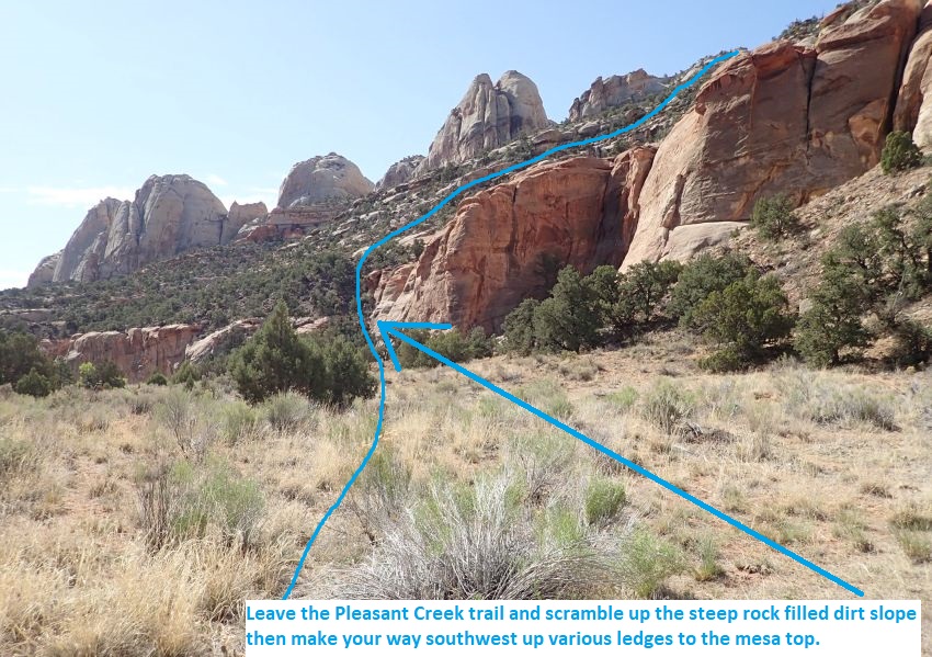
As you hike down
Pleasant Creek you may
come to a fork in the
trail on the south side
(jWinWanTp) where the
trail drops down to the
creek or follow trail
higher up on the bank.
To branch off to the
Wingate Wander route,
follow the fork to the
right up to the higher
bank. Then walk about
350 feet over to the
base (WinWan01) of a
rock and tree filled
dirt slope to scramble
up, crossing a small
drainage just before the
hill.
About 250 feet farther
is the top of the rock
and tree filled slope
(WinWan02). Form
there, walk and scramble
your way straight up a
mix of dirt and
slickrock for about 200
feet to the base of some
large sandstone
outcroppings (WinWan03)
that prevent further
travel upward.
From the base of the
outcropping (WinWan03),
turn right and walk west
contouring under the
flat sandstone walls.
About 300 feet farther
is an upclimb (WinWan04)
of about 5 feet to get
to the next higher
level. Continue up for
about 370 feet to a wide
dirt shelf.
Once on the wide dirt
shelf (WinWan05) veer
right and contour
southwest about 250 feet
to where the slopes
become more gentle
allowing you to scramble
up the hill again.
Note: There is a large
cairn close to here with
no signs of what the
intended route was for
that cairn.
A little over 200 feet
farther the slopes to
the south become more
gentle (WinWan06) but
still steep. Go south
walking and scrambling
up the mix of dirt and
slickrock.
About 300 feet farther
the steep slopes top out
(WinWan07) and travel
becomes easier. Continue
southwest about 500 feet
to where you can drop
down to a drainage below
via a weakness in the
rim.
Weakness in the rim
(WinWan08) allowing a
scramble to the minor
drainage below. From
here you can see the
chunky Wingate rim of
the first canyon in the
distance about 0.35 miles
southwest. Drop down and
route find your way
toward the upper end of
the canyon you can see.
You will cross over a
few minor drainages and
find your way up some
gentle ridges on the
way.
As you get closer to the
first technical canyon
you will be on the rim
(WinWan09) overlooking a
maze of sandstone fins
at the edge of the first
canyon. Note a very
large red flat fin that
looks inviting to walk
down. Do not walk down
that fin but instead
route find your way to
the right (west) about
130 feet over to the top
of a rubble filled
ravine. Just before
getting to that ravine
will be a large boulder
(WinWan10) to scramble
around on sloped
slickrock.
From the head of the
rubble filled ravine
(WinWan11), scramble
down the rubble for
about 200 feet to the
canyon floor
(yWinWanCyn1Tp) which is
where the start of the
first technical canyon
is.
The First Canyoneering / Technical Section:
From the bottom of
the ravine
(yWinWanCyn1Tp) walk
southwest down canyon.
About 100 feet down
canyon is a drop of
about 12 feet (WinWan20)
that is downclimbable
with features on the LDC
side. Partner assist may
be helpful for some.
After this drop is thick
vegetation in narrow
canyon and an easy 6
foot downclimb mixed in
there.
About 250 feet farther
is the only rappel in
this first canyon
(dWinWanCyn1R1).
Rap 1 (dWinWanCyn1R1) is
anchored from a bush and
drops about 20 feet with
a ledge mid way down to
a sandy area and a large
arch to crawl under.
Some may be able to
downclimb this rap but
will require some skill.
Continuing down canyon
is more bush whacking in
narrow canyon.
About 200 feet farther
is a large side cross
joint on the LDC side
just as the canyon
starts a 50 foot long
narrow section with a
couple downclimbs near
the end in winding walls
before opening to more
narrow canyon with
vegetation.
About 100 feet farther
is a boulder pile in the
canyon (WinWan22) with a
downclimb of about 12
feet on the other side.
Can downclimb straight
down or to a ledge on
the RDC side to walk.
A little over 100 feet
farther the canyon
widens out
(yWinWanCyn1Bt) to wider
wash walking with bushes
and small trees.
The short lived
technical fun is done
for this canyon but soon
you will be in the
second canyon which
offers a little more
meat and a much deeper
committed feeling.
Route Between
Canyons:
From where the
first canyon widens
(yWinWanCyn1Bt ) walk
about 350 feet to tall
30 foot skinny tree
(WinWan23) in the wash
shortly after passing a
tree with a very large
diameter trunk.
This huge trunked tree
followed by the tall
skinny tree is the
landmark telling you
that the exit out of the
canyon is close.
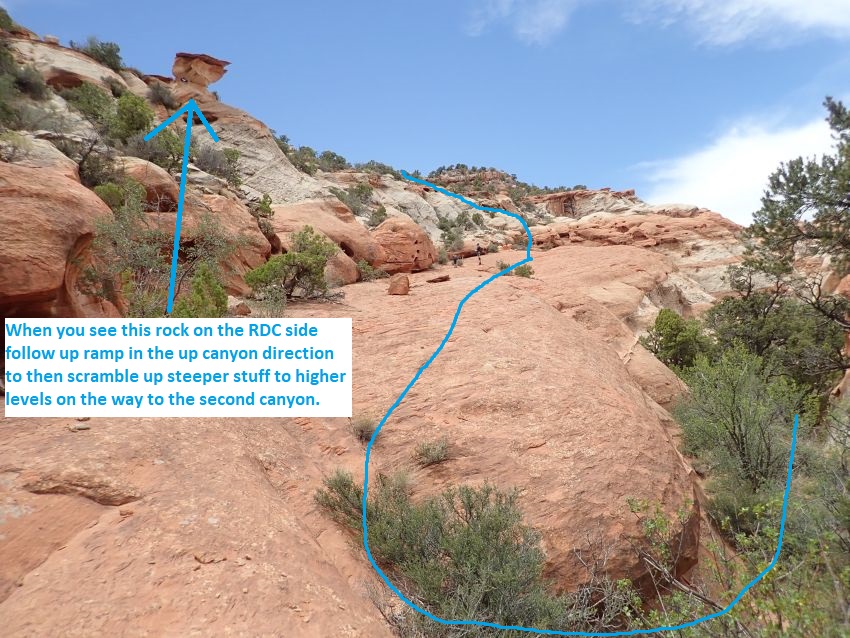
About 150 feet farther
is the bottom of
(WinWan24) a long
slickrock ramp running
back up canyon on the
RDC side allowing an
easy walk up to higher
ledges to start over to
the second canyon.
Follow south up the ramp
in the up canyon
direction about 250 feet
to where you can
scramble up steeper
sections to higher
levels.
Leave the top of
(WinWan30) the slickrock
ramp and scramble up
steeper rock about 125
feet up to wide dirt
shelf.
Once on the wide dirt
shelf (WinWan31), veer
right and walk southwest
up along the dirt shelf
for about 250 feet to
where you can veer left
and up to the south.
When leaving the dirt
shelf (WinWan32) veer
left (south) and
scramble steeper slopes
south about 280 feet up
to a wide dirt ridge.
From the top out on a
wide dirt ridge
(WinWan33) you can look
down toward the upper
portions of the second
canyon. Look south
and note a drainage
forming running down to
the canyon ahead. Find
your way down that wide
drainage for about 300
feet to the head of a
deep crack forming.
Note:
For a scenic side
trip you can walk west
over to and along a wide
red bench where you can
gain views west down
over the Pleasant Creek
Road. I highly
recommend walking over
to look out over the
road as it is a very
cool view.
At the head of the deep
crack (WinWan34) do not
drop into the crack.
Instead scramble down a
couple ledges then walk
south along the RDC
(west) rim of the crack
for about 120 feet to a
large boulder then a
drop of about 30 feet
down to a patch of
bushes in a pour off.
That pour off is where
you will rappel down
into the side crack to
enter the second canyon.
The Second Canyoneering / Technical Section:
At the pour off
(dWinWanCyn2R1) is where
you will rap into the
second canyon from a set
of bushes. To get
down to the bushes for
the rappel you will need
to circle around to the
right and get down a 12
foot drop that can be
partner assisted.
Rap 1 of the second
canyon (dWinWanCyn2R1)
is anchored from a set
of bushes and drops down
a mostly vertical wall
about 140 feet into a
deep cross joint.
From the bottom of the
rap you can walk and
scramble about 390 feet
down the cross joint
into the main canyon.
Once in the main canyon
(yWinWanCyn2Tp), turn
left and walk east down
wide vegetated canyon
past various cross
joints as the canyon
begins to narrow.
About 200 feet farther
is a drop (WinWan40) of
about 15 feet where the
canyon gets narrow. This
drop can be downclimbed
by stemming out about 15
feet then stemming down
about 10 feet.
Optionally a small arch
in the wall about head
high on the LDC side can
be used as an anchor to
rap or handline the
drop. At the bottom of
the drop is a wide
subway like section to
walk for about 60 feet
down to where the canyon
gets kind of skinny and
drops steeply.
As the canyon becomes
skinny (WinWan41) it
also begins to drop
steeply. This section is
about 80 feet long down
to the next rap and
drops about 80 feet in
skinny narrows where you
stem and slide down
along undulating walls.
There is also one
shallow pothole where
effort needs to be
exerted if you want to
try and keep dry feet.
At the end of the skinny
section is rap 2 for
this canyon.
Rap 2 (dWinWanCyn2R2)
anchored using a deadman
or water trap or
chockstone near the end
of a skinny section and
drops about 90 feet down
vertical wall into a
short cross joint.
Originally we used a
chockstone anchor which
has reportedly washed
out. A deadman anchor
can be built but
materials are sparse and
would need to be farmed
from below. It has been
reported the geometry
here works well with
water or sandtrap.is
anchored from a chock
stone near the end of a
skinny section and drops
about 90 feet down
vertical wall into a
short cross joint.
From
the bottom of the rap
walk about 20 feet to
the main canyon at a
confluence.
From the confluence
(WinWan42-conf) in walk
down canyon enjoying
deep dark scenic narrow
corridor to walk for
about 500 feet. The last
150 feet of the corridor
will require some light
and very easy galumphing
over a skinny crack.
Note:
If you would like
to see a long way up the
other fork you can walk
about 90 feet south up
the other fork to a
corner where you can
then look well over 100
feet west up the other
fork. It is interesting
to note that if coming
down the right fork you
would have no idea where
the left fork drops in
since you can not see
the crack you rapped
out of. Even knowing it is
there it can not be
seen.
About 500 feet farther
the corridor ends
(yWinWanCyn2Bt) and the
canyon opens up to wide
easy walking and some
vegetation.
The Exit:
As the
corridor ends
(yWinWanCyn2Bt) the exit
route is to continue
down this drainage all
the way to Pleasant
Creek where you then
turn left and hike up
Pleasant Creek back to
the cars. Sections
of the route down the
drainage to Pleasant
Creek have short drops
which could be rappelled
but bypassing them is
faster and easier and is
what is described here.
About 0.2 miles farther
is the first
(WinWan43EE-RDC) of 3
drops over about 150
feet of canyon with each
drop being about 15 to
20 feet and some
vegetation to push
through in a couple
spots. We opted to
bypass this section by
scrambling up steep
slickrock on the RDC
side to rim walk down
canyon about 370 feet
and back to the canyon
floor (WinWan44EE-RDC).
About 350 feet farther
is a shelf
(WinWan45Bypass) of
about 30 feet that is
easily bypassed up and
over on the LDC side
then down dirt and rock
slopes to a confluence.
This confluence is where
the two technical slots
you did join together.
From the confluence
(WinWan50Conf) walk
about 300 feet to the
first (WinWan51 EE-RDC)
of 3 drops of about 20
or 30 feet each over
about 100 feet of canyon
down to a rubble pile
with a couple short
drops and a bridge to
crawl under after.
We opted to bypass this
section by scrambling up
on the RDC side to rim
walk down canyon about
350 feet and back to the
canyon floor (WinWan52
EE-RDC).
About 800 feet farther
is a short section of
shallow potholes
(WinWan53) to walk
around on the LDC side.
About 0.5 miles farther
the wide wash goes into
canyon with tall walls
(WinWan54) for about 800
feet to a short open
spot. In this 800 feet
is easy walking in
narrow corridors and two
easy downclimbs of about
10 feet each.
After the corridor is a
short open spot
(WinWan55) followed by a
couple more short
narrows and short open
spots over the next 1000
feet then the canyon
begins to open up to
wide spaces.
As the canyon opens up
to wide spaces
(WinWan56), follow the
water course about 1100
feet to where it dumps
into Pleasant Creek (jWinWanBt).
Once in Pleasant Creek (jWinWanBt),
turn left and walk west
up Pleasant Creek and
follow trails up
Pleasant Creek about 2.6
miles back to the Upper
Pleasant Creek Trailhead
(pkPlsntCkTp)
Downloadable GPX files
available at
BG-Gear Store
(easier than manual entry and a great way to support
Bluugnome).
Waypoint naming convention and map symbol information can be found on the Glossary page.
Elevations are approximate.
BEFORE
manually entering coordinates set your system to WGS84 datum and Lat/Lon hddd.ddddd° coordinate format.
Inconsistent datum's and coordinate formats will result in location errors.
Click to show / expand the list of waypoints below........
| Wingate Wander (1) - Drive in to Trailhead |
- vCapReefVisit
Lat/Lon (WGS84): N 38.29111
W -111.26180
Elev: 5,208 Feet
Capitol Reef Visitor Center.
- extGrandWash
Lat/Lon (WGS84): N 38.25622
W -111.23287
Elev: 5,580 Feet
Exit off of the scenic drive to a dirt road into Grand Wash.
- exCapGorgeRd
Lat/Lon (WGS84): N 38.20802
W -111.19523
Elev: NaN Feet
To go to Reef Ramble, exit off of the Scenic Drive onto the Capitol Gorge road. Capitol Gorge Road goes off to the east and turns from dirt to pavement a little over 200 feet down the road just past a large parking area.
To go to Wingate Wander, continue south on Pleasant Creek Road which also turns to dirt just past this exit.
- exPlsntCkFldOf
Lat/Lon (WGS84): N 38.18515
W -111.18671
Elev: 5,954 Feet
Exit to the Pleasant Creek Field Office.
- PlsntCkCoral1
Lat/Lon (WGS84): N 38.18315
W -111.17975
Elev: NaN Feet
Coral and a few old buildings.
- pkPlsntCkTp
Lat/Lon (WGS84): N 38.18044
W -111.18081
Elev: 5,930 Feet
Parking area on west side of road to hike down into upper Pleasant Creek. This is just before the road drops down to cross over Pleasant Creek. High clearance is recomended if crossing the creek to continue south on Pleasant Creek Raod.
|
| Wingate Wander (2) - Approach to First Canyon |
- pkPlsntCkTp
Lat/Lon (WGS84): N 38.18044
W -111.18081
Elev: 5,930 Feet
Parking area on west side of road to hike down into upper Pleasant Creek. This is just before the road drops down to cross over Pleasant Creek. High clearance is recomended if crossing the creek to continue south on Pleasant Creek Raod.
- jWinWanTp
Lat/Lon (WGS84): N 38.18378
W -111.16843
Elev: 5,803 Feet
A fork on the Pleasant Creek trail on the south side of the creek where the trail drops down to the creek or follow trail higher up on the bank. To branch off to the Wingate Wander route, follow the fork to the right up to the higher bank. Then walk about 350 feet over to the base of a rock and tree filled dirt slope to scramble up, crossing a small drainage just before the hill.
- WinWan01
Lat/Lon (WGS84): N 38.18296
W -111.16799
Elev: NaN Feet
Base of a rock and tree filled slope to scramble up.
- WinWan02
Lat/Lon (WGS84): N 38.18235
W -111.16758
Elev: NaN Feet
Top of a rock and tree filled slope. Walk and scramble your way straight up a mix of dirt and slickrock for about 200 feet to the base of some large sandstone outcroppings that prevent further travel upward.
- WinWan03
Lat/Lon (WGS84): N 38.18180
W -111.16746
Elev: NaN Feet
Base of sandstone outcroppings. Turn right and walk west contouring under the flat sandstone walls.
- WinWan04
Lat/Lon (WGS84): N 38.18161
W -111.16845
Elev: NaN Feet
Upclimb of about 5 feet to get to the next higher level. Continue up for about 370 feet to a wide dirt shelf.
- WinWan05
Lat/Lon (WGS84): N 38.18078
W -111.16908
Elev: NaN Feet
Wide dirt shelf where you can veer right and contour southwest about 250 feet to where the slopes become more gentle allowing you to scramble up the hill again.
Note: There is a large cairn close to here with no signs of what the intended route was for that cairn.
- WinWan06
Lat/Lon (WGS84): N 38.18095
W -111.16987
Elev: NaN Feet
Slopes to the south become more gentle but still steep. Go south walking and scrambling up the mix of dirt and slickrock.
- WinWan07
Lat/Lon (WGS84): N 38.18032
W -111.17046
Elev: NaN Feet
Steep slopes top out and travel becomes easier. Continue southwest about 500 feet to where you can drop down to a drainage below.
- WinWan08
Lat/Lon (WGS84): N 38.17950
W -111.17188
Elev: NaN Feet
Weakness in the rim allowing a scramble to the minor drainage below. From here you can see the chunky Wingate rim of the first canyon in the distance about 0.35 miles southwest. Drop down and route find your way toward the upper end of the canyon you can see. You will cross over a few minor drainages and find your way up some gentle ridges on the way.
- WinWan09
Lat/Lon (WGS84): N 38.17554
W -111.17387
Elev: NaN Feet
On the rim overlooking a maze of sandstone fins at the edge of the first canyon. Note a very large red flat fin that looks inviting to walk down. Do not walk down that fin but instead route find your way to the right (west) about 130 feet over to the top of a rubble filled ravine. Just before getting to that ravine will be a large boulder to scramble around on sloped slickrock.
- WinWan10
Lat/Lon (WGS84): N 38.17541
W -111.17405
Elev: NaN Feet
Boulder to scramble around on sloped slickrock. Continue west a short distance to the head of a ravine.
- WinWan11
Lat/Lon (WGS84): N 38.17547
W -111.17427
Elev: 6,640 Feet
Head of a rubble filled ravine. Scramble down the rubble for about 200 feet to the canyon floor.
- yWinWanCyn1Tp
Lat/Lon (WGS84): N 38.17489
W -111.17422
Elev: NaN Feet
On the canyon floor at the base of a rubble filled ravine.
|
| Wingate Wander (3) - Two Canyon Technical Section |
- yWinWanCyn1Tp
Lat/Lon (WGS84): N 38.17489
W -111.17422
Elev: NaN Feet
On the canyon floor at the base of a rubble filled ravine.
- WinWan20
Lat/Lon (WGS84): N 38.17481
W -111.17389
Elev: NaN Feet
Drop of about 12 feet that is downclimbable with features on the LDC side. Partner assist may be helpful for some. After this drop is thick vegetation in narrow canyon and an easy 6 foot downclimb mixed in there.
- dWinWanCyn1R1
Lat/Lon (WGS84): N 38.17434
W -111.17321
Elev: NaN Feet
Rap 1 - Wingate Wander Canyon 1. Anchored from a bush and drops about 20 feet with a ledge mid way down to a sandy area and a large arch to crawl under. Some may be able to downclimb this rap but will require some skill. Continuing down canyon is more bush whacking in narrow canyon.
- WinWan21
Lat/Lon (WGS84): N 38.17456
W -111.17264
Elev: NaN Feet
Large side cross joint on the LDC side just as the canyon starts a 50 foot long narrow section with a couple downclimbs near the end in winding walls before opening to more narrow canyon with vegetation.
- WinWan22
Lat/Lon (WGS84): N 38.17468
W -111.17240
Elev: NaN Feet
Boulder pile in the canyon with a downclimb of about 12 feet on the other side. Can downclimb straight down or to a ledge on the RDC side to walk.
- yWinWanCyn1Bt
Lat/Lon (WGS84): N 38.17481
W -111.17205
Elev: NaN Feet
Canyon widens out to wider wash walking with bushes and small trees.
- WinWan23
Lat/Lon (WGS84): N 38.17516
W -111.17093
Elev: NaN Feet
Tall 30 foot skinny tree in the wash shortly after passing a tree with a very large diameter trunk. This huge trunked tree followed by the tall skinny tree is the landmark telling you that the exit out of the canyon is close.
- WinWan24
Lat/Lon (WGS84): N 38.17544
W -111.17051
Elev: NaN Feet
Bottom of a long slickrock ramp running back up canyon on the RDC side allowing an easy walk up to higher ledges to start over to the second canyon. Follow south up the ramp in the up canyon direction about 250 feet to where you can scramble up steeper sections to higher levels.
- WinWan30
Lat/Lon (WGS84): N 38.17482
W -111.17095
Elev: NaN Feet
Leave the top of the slickrock ramp and scramble up steeper rock about 125 feet up to wide dirt shelf.
- WinWan31
Lat/Lon (WGS84): N 38.17451
W -111.17086
Elev: NaN Feet
Wide dirt shelf. Veer right and walk southwest up along the dirt shelf for about 250 feet to where you can veer left and up to the south.
- WinWan32
Lat/Lon (WGS84): N 38.17392
W -111.17137
Elev: 6,522 Feet
Veer left (south) leaving the large dirt shelf and scramble steeper slopes south about 280 feet up to a wide dirt ridge.
- WinWan33
Lat/Lon (WGS84): N 38.17314
W -111.17144
Elev: 6,615 Feet
Top out on a wide dirt ridge where you can look down toward the upper portions of the second canyon. Look south and note a drainage forming running down to the canyon ahead. Find your way down that wide drainage for about 300 feet to the head of a deep crack forming.
Note: for a scenic side trip you can walk west over to and along a wide red bench where you can gain views west down over the Pleasant Creek Road.
- WinWan34
Lat/Lon (WGS84): N 38.17243
W -111.17094
Elev: NaN Feet
Head of a deep crack forming. Do not drop down into the crack. Instead scramble down a couple ledges then walk south along the RDC (west) rim of the crack for about 120 feet to a large boulder then a drop of about 30 feet down to a patch of bushes in a pour off.
- dWinWanCyn2R1
Lat/Lon (WGS84): N 38.17208
W -111.17086
Elev: NaN Feet
Rap 1 - Wingate Wander Canyon 2. Anchored from a set of bushes and drops down a mostly vertical wall about 140 feet into a deep cross joint. To get down to the bushes for the rappel you will need to circle around to the right and get down a 12 foot drop that can be partner assisted. From the bottom of the rap you can walk and scramble about 390 feet down into the main canyon.
- yWinWanCyn2Tp
Lat/Lon (WGS84): N 38.17111
W -111.17023
Elev: 6,420 Feet
Cross joint drops into the main canyon. Turn left and walk east down wide vegetated canyon past various cross joints for about 200 feet as the canyon begins to narrow.
- WinWan40
Lat/Lon (WGS84): N 38.17106
W -111.16947
Elev: NaN Feet
Drop of about 15 feet where the canyon gets narrow. This drop can be downclimbed by stemming out about 15 feet then stemming down about 10 feet. Optionally a small arch in the wall about head high on the LDC side can be used as an anchor to rap or handline the drop. At the bottom of the drop is a wide subway like section to walk for about 60 feet down to where the canyon gets kind of skinny and drops steeply.
- WinWan41
Lat/Lon (WGS84): N 38.17089
W -111.16941
Elev: NaN Feet
Canyon becomes kind of skinny and drops steeply. This section is about 80 feet long down to the next rap and drops about 80 feet in skinny narrows where you stem and slide down along undulating walls. There is also one shallow pothole where effort needs to be exerted if you want to try and keep dry feet.
- dWinWanCyn2R2
Lat/Lon (WGS84): N 38.17075
W -111.16920
Elev: NaN Feet
Rap 2 - Wingate Wander Canyon 2. Anchored using a deadman or water trap or chockstone near the end of a skinny section and drops about 90 feet down vertical wall into a short cross joint. Originally we used a chockstone anchor which has reportedly washed out. A deadman anchor can be built but materials are sparse and would need to be farmed from below. It has been reported the geometry here works well with water or sandtrap.
From the bottom of the rap walk about 20 feet to the main canyon at a confluence.
- WinWan42-conf
Lat/Lon (WGS84): N 38.17070
W -111.16915
Elev: NaN Feet
Confluence in the canyon. Walk down canyon enjoying deep dark scenic narrow corridor to walk for about 500 feet. The last 150 feet of the corridor will require some light and very easy galumphing over a skinny crack.
Note: If you would like to see a long way up the other fork you can walk about 90 feet south up the other fork to a corner where you can then look well over 100 feet west up the other fork. It is interesting to note that if coming down the right fork you would have no idea where the left fork drops in since you can not see the crack you rapped out of from the left fork. Even knowing it is there it can not be seen.
- yWinWanCyn2Bt
Lat/Lon (WGS84): N 38.17091
W -111.16741
Elev: 6,330 Feet
Corridor ends and the canyon opens up to wide easy walking and some vegetation.
|
| Wingate Wander (4) - Exit |
- yWinWanCyn2Bt
Lat/Lon (WGS84): N 38.17091
W -111.16741
Elev: 6,330 Feet
Corridor ends and the canyon opens up to wide easy walking and some vegetation.
- WinWan43EE-RDC
Lat/Lon (WGS84): N 38.17280
W -111.16531
Elev: NaN Feet
First of 3 drops over about 150 feet of canyon with each drop being about 15 to 20 feet and some vegetation to push through in a couple spots.
We opted to bypass this section by scrambling up steep slickrock on the RDC side to rim walk down canyon about 370 feet and back to the canyon floor.
- WinWan44EE-RDC
Lat/Lon (WGS84): N 38.17361
W -111.16445
Elev: NaN Feet
Drop back down to canyon floor after bypassing 3 short drops.
- WinWan45Bypass
Lat/Lon (WGS84): N 38.17389
W -111.16330
Elev: NaN Feet
Shelf of about 30 feet that is easily bypassed up and over on the LDC side then down dirt and rock slopes to a confluence.
- WinWan50Conf
Lat/Lon (WGS84): N 38.17411
W -111.16287
Elev: NaN Feet
Confluence of WinWan 1 Canyon and WinWan 2 Canyon. This confluence is where the two technical slots you did join together.
- WinWan51 EE-RDC
Lat/Lon (WGS84): N 38.17424
W -111.16189
Elev: NaN Feet
First of 3 drops of about 20 or 30 feet each over about 100 feet of canyon down to a rubble pile with a couple short drops and a bridge to crawl under after.
We opted to bypass this section by scrambling up on the RDC side to rim walk down canyon about 350 feet and back to the canyon floor.
- WinWan52 EE-RDC
Lat/Lon (WGS84): N 38.17442
W -111.16068
Elev: NaN Feet
Back down to the canyon floor after bypassing a short section with 3 small drops.
- WinWan53
Lat/Lon (WGS84): N 38.17456
W -111.15809
Elev: NaN Feet
Short section of shallow potholes to walk around on the LDC side.
- WinWan54
Lat/Lon (WGS84): N 38.17805
W -111.15175
Elev: NaN Feet
Wide wash goes into canyon with tall walls for about 800 feet to a short open spot. In this 800 feet is easy walking in narrow corridors and two easy downclimbs of about 10 feet each.
- WinWan55
Lat/Lon (WGS84): N 38.17888
W -111.14970
Elev: NaN Feet
Short open spot followed by a couple more short narrows and short open spots over the next 1000 feet then the canyon begins to open up to wide spaces.
- WinWan56
Lat/Lon (WGS84): N 38.18076
W -111.14745
Elev: NaN Feet
Canyon opens up to wide spaces. Follow the water course about 1100 feet to where it dumps into Pleasant Creek.
- jWinWanBt
Lat/Lon (WGS84): N 38.18229
W -111.14450
Elev: 5,650 Feet
Confluence of the lower end of the Wingate Wander route an Pleasant Creek. Turn left and walk west up Pleasant Creek and follow trails up Pleasant Creek about 2.6 miles back to the Upper Pleasant Creek Trailhead.
- pkPlsntCkTp
Lat/Lon (WGS84): N 38.18044
W -111.18081
Elev: 5,930 Feet
Parking area on west side of road to hike down into upper Pleasant Creek. This is just before the road drops down to cross over Pleasant Creek. High clearance is recomended if crossing the creek to continue south on Pleasant Creek Raod.
|