Canyoneering Route Description
Wayne's Wonderland Canyon - 4B III
Capitol Reef National Park, Utah.
09-13-14, 8 people, 1 Day (Travel time in route 7 hours)

Time Required - 6 to 8 hours
Distance - 3.2 miles Total, 0.7 miles Technical
Rappels - 5 Rappels, Longest Rappel 200 feet.
A rope slightly longer than 200 is recommended.
Elevation Range - 5230 - 6140 Feet
Shuttle Required - No Vehicle - Passenger
Permit Required - Yes
Rappelling and anchor gear, Ropes and or pull cords for rappels up
to 200 feet and 60 feet of 1 inch webbing for sling placement.
A rope of a little more than 200 feet is recommended. Wetsuits
are generally a good idea even when warm. Sandtrap.
Potshot (just in case).
A watertrap is NOT needed but can be put to good use for practice in
a couple spots if you happen to have one.
Wayne's Wonderland is a fun
scenic route worth the visit. The approach offers big open views over the
area while the canyon offers some pothole fun and scenic slots below with a
few anchor challenges.
The approach up to the mesa top will require
some route finding skills to navigate the cliff bands to the top.
The keeper in the slot just before the final rap could
be challenging in the right conditions. It may be a good idea to have
a potshot on hand just incase but you will likely not need it.
Note / Warning:
Rap 3 is the biggest drop in the canyon and is a true 200
feet if you extend the anchor to the lip. A rope slightly longer than 200
feet is recommended.
Or rap 3 has a large pothole / ledge about 110
feet down where you could set a second rappel but a watertrap would likely
be the best choice there. Another option is to join ropes together and pass
the knot while on the large ledge. To do this a retrievable anchor like a
Sandtrap or Smooth Operator will need to be used to eliminate the need for
the knot to pulled through a rappel ring. A Sandtrap works best here.
To get to the Trailhead
From Torrey Utah at the junction of highways 12 and 24 drive
east on highway 24 for 9.7 miles to the turn off on the right
(south) for the Capitol Reef Visitor Center. Pass the turn
off and continue east on highway 24 for another 4.5 miles to a
pull out on the right (south) side of the road for the lower
Grand Wash trailhead. This is just after passing Grand
Wash and just before reaching mile marker 84. Park in the
Grand Wash trailhead (tGrandWashLwr).
To leave the Exit Vehicle / Escape Pod
No exit vehicle is needed. This is done as a loop route.
GPS coordinate information listed at the bottom. For information about waypoint naming and map symbols, refer to the
Glossary page.

Click the links for maps of the route.
Map of the entire route.
Map zoomed in on part of approach.
Map of the technical section.
The Approach:
From lower Grand Wash
trailhead (tGrandWashLwr)
walk east on highway 24
for about 0.32 miles to
a wide wash on the right
(south) where you can
see a steeply sloped
ravine about 400 feet
from the road running up
to the southeast.
The bottom of Wayne's
Wonderland is about 900
feet after leaving the
parking area which you
will pass by on as you
start the approach.
When you get to the wide
wash (jWayneWndr) turn
right leave the road and
hike southeast up the
wash for about 450 feet
to the base
(WayneWndr01) of a
rubble filled ravine
running up the left side
of the wash. You can see
all the way up the
ravine from the road.
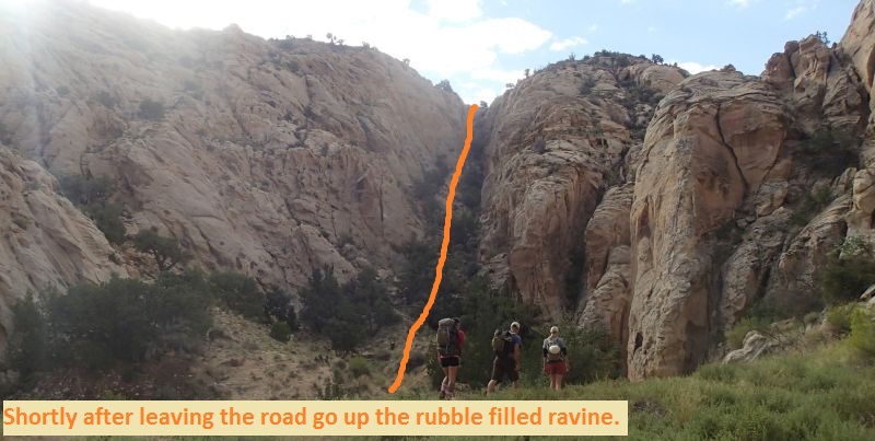
Go up the ravine to the
top out (WayneWndr02)
about 500 feet away.
From the top out
continue southeast
dropping down into a
drainage / wash then
begin walking up the
wash.
About 400 feet southeast
up the wash veer left to
leave the wash going up
to the southeast looking
for a weakness on the
left allowing you to
scramble up onto the
slickrock above.
When up on the slickrock
above the wash
(WayneWndr03) route find
your way southeast up
along sloped slickrock
then up a dirt and rock
slope to its top out
about 900 feet away.
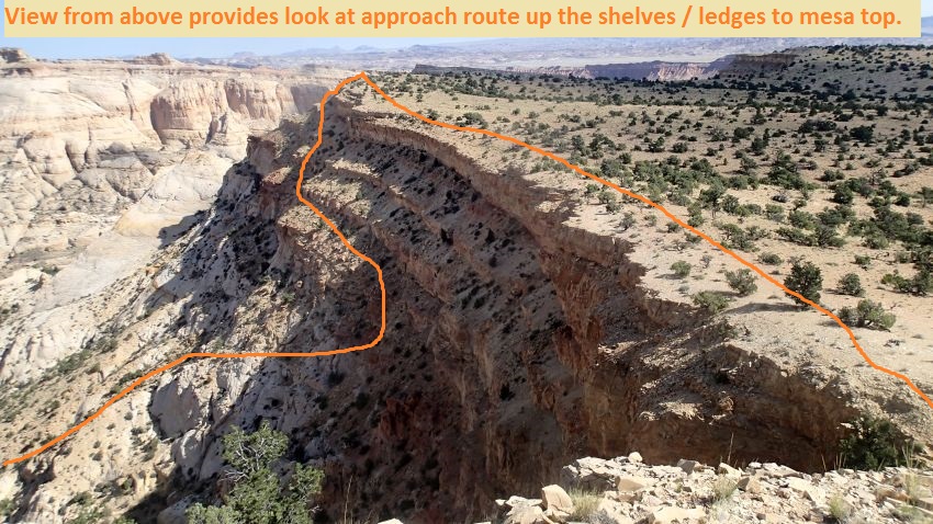
From the top of the dirt
and rock slope
(WayneWndr04) continue
scrambling up slickrock
for about 200 feet to
get as high as you can
to get to a weakness in
the cliff band allowing
access to a shelf /
ledge.
When you have scrambled
as high as possible
(WayneWndr05) turn left
to walk north along a
slanted ledge / shelf.
About 100 feet along the
shelf / ledge you will
go around a point
(WayneWndr06) and
continue north along the
shelf.
Another 250 feet along
the shelf is a weakness
(WayneWndr07) where you
can scramble up to the
next higher ledge /
shelf. On the next
shelf continue north
about 60 feet to another
weakness where you can
scramble up one more
level then continue
north to where you can
scramble up to the mesa
top near the end of a
point.
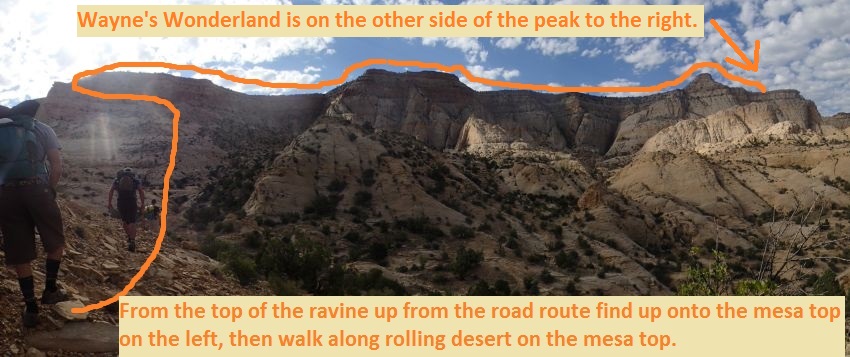
Once up on the mesa top
(WayneWndr08) turn right
and walk south along the
mesa through rolling
desert while roughly
following along the edge
of the cliff.
About 0.34 miles along
the mesa will be a small
slope to walk to the top
of (WayneWndr09).
Continue southwest then
west roughly following
the edge of the mesa for
about 0.5 miles to a
spot where you can walk
out on a wide point
jutting out north from
the mesa.
When you get to the
ridge (WayneWndr10) pass
the ridge and continue
southwest route finding
your way about 300 feet
to the top of a ravine
running down from the
mesa.
From the top of the
ravine (WayneWndr11)
route find your way
northwest down the
rubble filled ravine.
Getting down into the
top portion of the
ravine can be awkward as
you find a way to
downclimb down slopes
with a lot of large
loose flat rocks. The
LDC (west) side of the
ravine provides the best
entry. The first 300
feet of the ravine is
steep leading down to a
shelf to bypass and
becomes more gently
sloped after the shelf.
About 300 feet down the
ravine (WayneWndr12) is
a shelf of about 15 feet
in the ravine which can
be bypassed RDC to avoid
the crypto on the LDC
side. The ravine becomes
more gently sloped after
bypassing this shelf.
About 600 feet farther
the ravine down from the
rim meets the main
drainage and a drop of
about 35 feet that is
easily bypassed on the
LDC side. This is
where the technical
portion begins
(yWayneWndrTp).
The Canyoneering / Technical Section:
From the start of
the technical section (yWayneWndrTp)
bypass the 35 foot drop
and walk a little over
200 feet to the top of a
narrow slot
(WayneWndr13) to
downclimb through.
The slot has two
elevator / stem style
downclimbs of about 15
and 20 feet each down to
pools that can be waist
to swimmer depth
depending on levels.
Then an easy 8 foot down
downclimb to wide easy
walking.
After the short walk is
the top of another slot
(WayneWndr14) to
downclimb through with 3
elevator / stem style
downclimbs of about 15
feet each. After the 3
downclimbs is the top of
rap 1.
Rap 1 (dWayneWndrR1) is
anchored from a cairn
anchor about 25 feet
back from the drop and
drops about 25 feet down
a slope.
Optionally a back drag
anchor could be used
here. Walk
about 250 feet down to
rap 2.
Rap 2 (dWayneWndrR2)
anchored LDC from large
boulders and drops about
25 feet down the LDC
wall. After rap 2 is
easy walking in deep
slot for a little over
200 feet to 2 downclimbs
of about 6 to 8 feet
before reaching the
start of a pothole
section.
The pothole section
(WayneWndr15) is a about
100 feet long section of
shallow potholes that
are easy to play through
down to rap 3.
Rap 3 (dWayneWndrR3)
anchored using a
sandtrap and drops a
total of 200 feet over
two stages with a large
pothole about 110 feet
down that you can walk
around in. Be sure to
set the anchor for rap 3
so the rope starts at
the lip of the drop to
make it a 200 foot drop.
Setting the anchor back
too far will create the
need for more rope.
Optionally rap 3 can be
done as 2 rappels by
anchoring at the
midpoint pothole using a
watertrap or sand trap
depending on conditions.
Note:
For rap 3, a second rope
can be tied on at the
midpoint pothole and the
knot passed while in the
midpoint pothole. This
will be helpful if you
are unsure your ropes
reach. This can not be
done with a traditional
pull anchor as the knot
will need to pass
through the rap ring
above. If tying ropes
together a sandtrap or
releasable anchor like
the Smooth Operator
needs to be used.
After rap 3 are a few
shallow potholes and one
drop of about 8 feet
that will require
partner assist before
getting to rap 4.
Rap 4 (dWayneWndrR4)
anchored about 20 feet
back using a deadman
anchor and uses about
160 feet of rope going
down a slope, over a
large pothole then down
a slightly sloped
shallow crack. At
the bottom of the rap
the canyon turns hard
right to travel
northeast.
About 150 feet down
canyon to the start
(WayneWndr16) of a
narrow section with 2 or
3 downclimbs of 8 to 10
feet each and a few
pools that could be
swimmers if full.
Next is a short open
section (WayneWndr17).
Over the next 700 feet
the canyon has a mix of
short open spots and
narrow slots with a
couple downclimbs of
about 8 feet and a few
pools that can be
swimmers when full.
Just before getting to
the final rap is the
start of a 140 foot long
pothole section
(WayneWndr18) leading
down to the final
rappel. There is one
pothole in this section
that can be a keeper in
the right conditions. A
swimming partner assist
works well to get the
first person out. Just
before reaching the
final rap is a steeply
sloped downclimb of
about 6 feet that may
also require a partner
assist.
Rap 5 (dWayneWndrR5)
anchored using rocks in
the pool or optionally a
watertrap and drops
about 40 feet. If no
rocks are present you
can send someone down on
meat and farm them from
below. Another option
would be to anchor from
a large rock under water
in the pothole just up
canyon.
After rap 5 walk about
800 feet to highway 24.
The Exit:
From the
bottom of Wayne's
Wonderland where it
meets highway 24
(yWayneWndrBt) turn left
and walk back to the
lower Grand Wash
trailhead (tGrandWashLwr).
Downloadable GPX files
available at
BG-Gear Store
(easier than manual entry and a great way to support
Bluugnome).
Waypoint naming convention and map symbol information can be found on the Glossary page.
Elevations are approximate.
BEFORE
manually entering coordinates set your system to WGS84 datum and Lat/Lon hddd.ddddd° coordinate format.
Inconsistent datum's and coordinate formats will result in location errors.
Click to show / expand the list of waypoints below........
| Wayne's Wonderland (1) - Approach |
- tGrandWashLwr
Lat/Lon (WGS84): N 38.27800
W -111.19214
Elev: 5,240 Feet
Grand Wash trailhead down by highway 24 just west of mile marker 84.
To go to Waynes Wonderland Canyon walk east on highway 24 for about 0.32 miles to a wide wash on the right (south) where you can see a steeply sloped ravine about 400 feet from the road running up to the southeast. The bottom of Wayne's Wonderland is about 900 feet after leaving the parking area which you will pass by on as you start the approach.
- yWayneWndrBt
Lat/Lon (WGS84): N 38.27738
W -111.18913
Elev: 5,240 Feet
Bottom of Waynes Wonderland where the route meets highway 24. Just east of mile marker 84.
- jWayneWndr
Lat/Lon (WGS84): N 38.27838
W -111.18668
Elev: 5,230 Feet
To go to Waynes Wonderland leave the road and hike southeast up the wash for about 450 feet to the base of a rubble filled ravine running up the left side of the wash. You can see all the way up the ravine from the road.
- WayneWndr01
Lat/Lon (WGS84): N 38.27763
W -111.18554
Elev: NaN Feet
Bottom of a rubble filled ravine running up to the southeaast. Go up the ravine to the top out about 500 feet away.
- WayneWndr02
Lat/Lon (WGS84): N 38.27651
W -111.18454
Elev: NaN Feet
Top of the rubble filled approach ravine. To continue to Waynes Wonderland continue southeast dropping down into a drainage / wash then begin walking up the wash.
About 400 feet southeast up the wash veer left to leave the wash going up to the southeast looking for a weakness on the left (east) allowing you to scramble up onto the slickrock above.
- WayneWndr03
Lat/Lon (WGS84): N 38.27554
W -111.18167
Elev: NaN Feet
Top of a weakness where you can scramble up onto the slick rock above a wash. Route find your way southeast up along sloped slickrock then up a dirt and rock slope to its top out about 900 feet away.
- WayneWndr04
Lat/Lon (WGS84): N 38.27348
W -111.18007
Elev: NaN Feet
Top of a dirt and rock slope. Continue scrambling up slickrock for about 200 feet to get as high as you can to get to a weakness in the cliff band allowing access to a shelf / ledge.
- WayneWndr05
Lat/Lon (WGS84): N 38.27351
W -111.17930
Elev: NaN Feet
After scrambling as high as you can on the cliff band turn left to walk north along a slanted ledge / shelf.
- WayneWndr06
Lat/Lon (WGS84): N 38.27378
W -111.17938
Elev: NaN Feet
As you walk north along the slanted ledge / shelf you will go around a point here. Continue north along the shelf.
- WayneWndr07
Lat/Lon (WGS84): N 38.27446
W -111.17918
Elev: NaN Feet
A weakness where you can scramble up to the next higher ledge / shelf. On the next shelf continue north about 60 feet to another weakness where you can scramble up one more level then continue north to where you can scramble up to the mesa top near the end of a point.
- WayneWndr08
Lat/Lon (WGS84): N 38.27477
W -111.17875
Elev: 6,000 Feet
Final scramble up to the mesa top out near the end of a point. To continue to Wayne's Wonderland turn right and walk south along the mesa through rolling desert while roughly following along the edge of the cliff.
- WayneWndr09
Lat/Lon (WGS84): N 38.27025
W -111.17972
Elev: 6,110 Feet
Walk up to the top of a small slope on the mesa. Continue southwest then west roughly following the edge of the mesa for about 0.5 miles to a spot where you can walk out on a wide point jutting out north from the mesa.
- WayneWndr10
Lat/Lon (WGS84): N 38.26775
W -111.18841
Elev: 6,140 Feet
Spot where you could trun right and walk out on a wide ridge to the north. To go to Wayne's Wonderland pass the ridge and continue southwest route finding your way about 300 feet to the top of a ravine running down from the mesa.
- WayneWndr11
Lat/Lon (WGS84): N 38.26703
W -111.18901
Elev: NaN Feet
Top of a ravine to go down to get into Wayne's Wonderland. Route find your way northwest down the rubble filled ravine. Getting down into the top portion of the ravine can be awkward as you find a way to downclimb down slopes with a lot of large loose flat rocks. The LDC (west) side of the ravine provides the best entry. The first 300 feet of the ravine is steep leading down to a shelf to bypass and becomes more gently sloped after the shelf.
- WayneWndr12
Lat/Lon (WGS84): N 38.26772
W -111.18963
Elev: NaN Feet
Shelf of about 15 feet in the ravine which can be bypassed RDC to avoid the crypto on the LDC side. The ravine becomes more gently sloped after bypassing this shelf.
- yWayneWndrTp
Lat/Lon (WGS84): N 38.26877
W -111.19096
Elev: 5,890 Feet
Top of Wayne's Wonderland where the ravine down from the rim meets the main drainage and a drop of about 35 feet that is easily bypassed on the LDC side.
|
| Wayne's Wonderland (2) - Canyon and Exit |
- yWayneWndrTp
Lat/Lon (WGS84): N 38.26877
W -111.19096
Elev: 5,890 Feet
Top of Wayne's Wonderland where the ravine down from the rim meets the main drainage and a drop of about 35 feet that is easily bypassed on the LDC side.
- WayneWndr13
Lat/Lon (WGS84): N 38.26932
W -111.19115
Elev: NaN Feet
Top of a narrow slot to downclimb through with two elevator / stem style downclimbs of about 15 and 20 feet each down to pools that can be waist to swimmer depth depending on levels. Then an easy 8 foot down downclimb to wide easy walking.
- WayneWndr14
Lat/Lon (WGS84): N 38.26964
W -111.19146
Elev: NaN Feet
Another narrow slot to downclimb through with 3 elevator / stem style downclimbs of about 15 feet each. After the 3 downclimbs is the top of rap 1.
- dWayneWndrR1
Lat/Lon (WGS84): N 38.27009
W -111.19159
Elev: NaN Feet
Rap 1 - Wayne's Wonderland. Anchored from a cairn anchor about 25 feet back from the drop and drops about 25 feet down a slope. Optionally a back drag anchor could be used here.
- dWayneWndrR2
Lat/Lon (WGS84): N 38.27061
W -111.19205
Elev: NaN Feet
Rap 2 - Waye's Wonderland. Anchored LDC from large boulders and drops about 25 feet down the LDC wall. After rap 2 is easy walking in deep slot for a little over 200 feet to 2 downclimbs of about 6 to 8 feet before reaching the start of a pothole section.
- WayneWndr15
Lat/Lon (WGS84): N 38.27093
W -111.19258
Elev: NaN Feet
Start of a 100 feet long section of shallow potholes that are easy to play through down to rap 3.
- dWayneWndrR3
Lat/Lon (WGS84): N 38.27121
W -111.19263
Elev: NaN Feet
Raps 3 - Wayne's Wonderland. Anchored using a sandtrap and drops a total of 200 feet over two stages with a large pothole about 110 feet down that you can walk around in. Be sure to set the anchor for rap 3 so the rope starts at the lip of the drop to make it a 200 foot drop. Setting the anchor back too far will create the need for more rope. Optionally rap 3 can be done as 2 rappels by anchoring at the midpoint pothole using a watertrap or sand trap depending on conditions.
Note:
For rap 3, a second rope can be tied on at the midpoint pothole and the knot passed while in the midpoint pothole. This will be helpful if you are unsure your ropes reach. This can not be done with a traditional pull anchor as the knot will need to pass through the rap ring above. If tying ropes together a sandtrap or releasable anchor like the Smooth Operator needs to be used.
After rap 3 are a few shallow potholes and one drop of about 8 feet that will require partner assist before getting to rap 4.
- dWayneWndrR4
Lat/Lon (WGS84): N 38.27158
W -111.19276
Elev: NaN Feet
Rap 4 - Wayne's Wonderland. Anchored about 20 feet back using a deadman anchor and uses about 160 feet of rope going down a slope, over a large pothole then down a slightly sloped shallow crack. At the bottom of the rap the canyon turns hard right to travel northeast.
- WayneWndr16
Lat/Lon (WGS84): N 38.27197
W -111.19291
Elev: NaN Feet
A narrow section with 2 or 3 downclimbs of 8 to 10 feet each and a few pools that could be swimmers if full.
- WayneWndr17
Lat/Lon (WGS84): N 38.27368
W -111.19206
Elev: NaN Feet
Short open walking section. Over the next 700 feet the canyon has a mix of short open spots and narrow slots with a couple downclimbs of about 8 feet and a few pools that can be swimmers when full.
- WayneWndr18
Lat/Lon (WGS84): N 38.27535
W -111.19101
Elev: NaN Feet
Start of a 140 foot long pothole section leading down to the final rappel. There is one pothole in this section that can be a keeper in the right conditions. A swimming partner assist works well to get the first person out. Just before reaching the final rap is a steeply sloped downclimb of about 6 feet that may also require a partner assist.
- dWayneWndrR5
Lat/Lon (WGS84): N 38.27572
W -111.19090
Elev: NaN Feet
Rap 5 - Wayne's Wonderland. Anchored using rocks in the pool or optionally a watertrap and drops about 40 feet. If no rocks are present you can send someone down on meat and farm them from below. Another option would be to anchor from a large rock under water in the pothole just up canyon.
After rap 5 walk about 800 feet to highway 24 to complete the route.
- yWayneWndrBt
Lat/Lon (WGS84): N 38.27738
W -111.18913
Elev: 5,240 Feet
Bottom of Waynes Wonderland where the route meets highway 24. Just east of mile marker 84.
- tGrandWashLwr
Lat/Lon (WGS84): N 38.27800
W -111.19214
Elev: 5,240 Feet
Grand Wash trailhead down by highway 24 just west of mile marker 84.
To go to Waynes Wonderland Canyon walk east on highway 24 for about 0.32 miles to a wide wash on the right (south) where you can see a steeply sloped ravine about 400 feet from the road running up to the southeast. The bottom of Wayne's Wonderland is about 900 feet after leaving the parking area which you will pass by on as you start the approach.
|