Canyoneering Route Description
Smokestack Canyon - 3A III
Capitol Reef National Park, Utah.
06-11-11, 6 people, 1 Day (Travel time in route 7.7 hours)

09-12-14, 2 people, 1 Day (Travel time in route 7.1 hours)
Time Required - 5 to 7.5 hours
Distance - 5.2 miles Total, 0.9 miles Technical
Rappels - 2 Rappels, Longest Rappel 115 feet.
Elevation Range - 6000 - 6970 Feet
Shuttle Required - No Vehicle - Passenger
Permit Required - Yes
Rappelling and anchor gear, Ropes and or pull cords for rappels up
to 110 feet and 50 feet of 1 inch webbing for sling placement.
Thanks to John Diener for scouting out and setting up a trip to get
down this canyon. Also, Thank you to John for the invite to join
his group on that first decent.
The route described here is for the Right Fork of Smokestack
Canyon. The left fork would involve a big rap at the head of the
canyon then a wash walk to the confluence of the left and right
forks. The fun is in the Right Fork of Smokestack Canyon. But you
do get some great views from the top of the head of the left fork,
so the route described here takes you by there for a look-see on
your way over to the right fork.
As always, try to stay off the crypto biotic soils in the area.
There are a lot of cross joint fractures in the area giving
Smokestack Canyon the feel of traveling through a fractured and
broken maze.
Smokestack canyon does not offer a lot of bang for the buck since
the canyon is short compared to the rest of the route. However
Smokestack is a fun canyon and worth checking out if you have time.
A couple of cautions about the rappels: Before sending everyone down
the down climb just before rap 1 have people below check the anchor
for rap 1. If there is insufficient material for an anchor, those
still at the top of the down climb can farm rocks to build the dead
man anchor. Rap 2 is an awkward start due to the need to set the
rap ring over the lip of the rappel to avoid rope grooves.
With this in mind I would not suggest this canyon for complete
beginners. Smokestack Canyon however is a great canyon for
intermediate canyoneers looking to practice setting anchors properly
to minimize rope grooves.
To get to the Trailhead
From the junction of highways 12 and 24, drive east on highway
24 toward Capitol Reef for 6.8 miles to a turn off on the left
for Chimney Rock Trail.
OR
From the visitor center in Capitol Reef, drive 3 miles east on
highway 24 to a turn off on the right for Chimney Rock Trail.
The turn off is paved and runs a couple hundred feet to the
parking area at the Chimney Rock Trailhead (tChimneyRock).
To leave the Exit Vehicle / Escape Pod
No exit vehicle is needed. This is done as a loop route.
GPS coordinate information listed at the bottom. For information about waypoint naming and map symbols, refer to the
Glossary page.

Click the links for maps of the route.
Map of the entire route.
Map of the approach route.
Map of the technical section.
The Approach:
From the Chimney Rock trailhead (tChimneyRock), start
north east on the Chimney Rock trail.
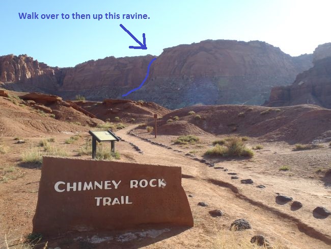
View from the Chimney Rock Trailhead. Route find your way
to the ravine with the blue line and go up it.
About 150 feet from the trailhead turn left (north west) and
leave the trail (wSmokStakRP-01). It is not important exactly where
you leave the trail just look for a convenient spot to do so.
After leaving the trail, walk northwest about 500 feet over to a
wash running up to the north east (wSmokStakRP-02). When you get to
the wash turn right and start walking north east up the wash.
In about 0.2 miles, the wash crosses over some whitish sandstone
(wSmokStakRP-03). Continue up the wash passing by some whitish sandstone
outcroppings.
Another 0.2 miles up, the wash will turn right (wSmokStakRP-04) and
go east up toward a ravine. As you look east up the wash toward the
ravine you should see a pointed peak to the right of the ravine and
the cliff leading up to the mesa top to the right of the ravine.
Walk up the ravine shown with the pointy peak on the right and
the cliffs of the mesa on the left.
About 350 up the wash to the east will be the base of the ravine
(wSmokStakRP-05).
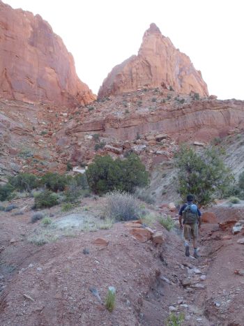
Continue east up the ravine. Travel up the ravine involves boulder
hoping and scrambling most of the way up the steep slope. A little
over 500 feet up the ravine, the walls get higher making it feel
more like a small canyon (wSmokStakRP-06).
Shortly after the ravine takes on a canyon feel, you will have a
section of easy travel on along a moderately flat section for about
400 feet. Part way up this kind of level section will be an up
climb of about 8 feet which is made easier by a log leaned on the
wall. if the log is not there a partner assist will easily get
you up the 8 foot upclimb.
Next is another steep section of the ravine to scramble up. Near
the start of this next steep section will be an up climb of about 10
feet or so (wSmokStakRP-07). To get up this upclimb you can
scramble up the center section or spice it up a little by chimneying
up a crack on the LUC
(north) side of the ravine.
The second steep section of the ravine is filled with boulders to
hop and scramble up just like the first steep section. About 275
feet up the second steep section the ravine starts to level off a
little at the top of a sandstone scree area (wSmokStakRP-08). This
spot is about 250 feet before reaching the obvious head wall of the
ravine and is also the bottom of a side slot on the left (north) that climbs
north up out of the ravine toward the mesa top.
Note:
As you get to the top of the scree like section and start to see the
obvious headwall of the ravine start looking for the side slot on
the left (north) side.
The angle of the side slot is such that you will likely not notice
the side slot until you are right on it or a little past it.
The bottom of the side slot
(wSmokStakRP-08) is about 250 feet from the obvious head wall of the
ravine and looks like an obvious route that ramps up out of the
ravine. Travel up the side slot is mostly easy scrambling with
a few easy up climbs of 4 or 5 feet each to get over some of the
boulder debris in the slot.
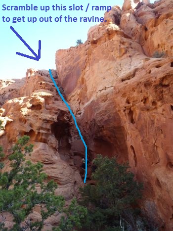
Scramble up out of the ravine using this slot / ramp.
The side slot up out of the ravine goes for about 175 feet up to its top out
(wSmokStakRP-09) on a large ledge. From the top out of the side
slot on the ledge, veer left and walk west along the ledge for about
250 feet to the start of a short scramble up climb to get up onto the mesa
above.
After the short scramble up onto the top of the mesa (wSmokStakRP-10),
turn right and route find your way east along the mesa gradually
gaining elevation. Your goal is to get up to a saddle like
spot on the east side of a rocky point about 700 feet from the top
of the scramble. The saddle like spot will not be visible
until you are about 300 feet east of the scramble up.
When the saddle like spot comes into view route find your way up to
it.
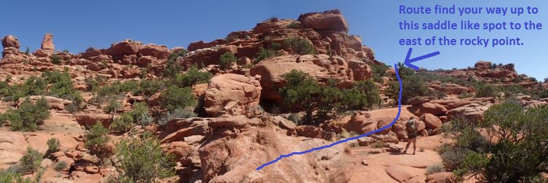
After walking a few hundred feet east along the mesa the saddle
like spot to the east of the rocky point comes into view.
Route find your way up to it.
When you get to the saddle like spot up on the east side of the
rocky point (wSmokStakRP-11), wrap left around to the north side of
the rocky peak. As you wrap around the point, contour around
it and do not drop in elevation but instead contour around very
gradually gaining elevation to get up over to mostly flat terrain
for easy walking about 150 feet north of the saddle and rocky point.
When you get up to the semi flat easy walking terrain
(wSmokStakRP-12), walk due north over rolling slickrock with
boulders and junipers. After about 600 feet the terrain will
begin to slope more steeply down toward rolling desert to the north
(wSmokStakRP-13).
When the terrain begins to slope more steeply begin walking down the
slope slightly east of north (about 15 degrees true) toward a wash
about 0.2 miles away that drops down toward the east.
Note:
When walking down toward the drainage it is important to note that
your bearing of travel is important since it will help you identify
the drainage itself. If you walk slightly west of north (about
340 degrees true) then you get to the wash where it is very shallow
and almost unnoticeable so the odds of crossing it and continuing
along rolling desert are high. If you walk just east of north
(about 15 degrees true) as described here you will get to the wash
where it has high side banks and is very noticeable.
When you get to the wash turn right and follow it down to the east.
A few hundred feet down the wash is drop of about 25 feet high
(wSmokStakRP-14). When you get to the top of this drop do not
go over the drop. Instead scramble up out of the wash on the
LDC (north) side.
After getting up out of the wash route find your way north east
about 550 feet over to the top of (wSmokStakRP-15) a shallow canyon
like drainage dropping down to the south which is just another fork
of the wash you just scrambled up out of. As you get over to
the top of this other fork you can look down that fork to the south
and you can also look east down the Left Fork of Smokestack Canyon.
Note:
The left Fork of Smokestack Canyon is not the fork you will be
dropping down for this route. But this point (wSmokStakRP-15) makes a good
visual navigation point. The canyon like fork to the
south is shallow and not to interesting looking. The Left Fork of
Smokestack to the east is very deep and has a very tall sheer faced
LDC wall.
Travel down the left fork to the where the right fork joins in
would be a big rappel of likely over 200 feet then a wash walk and
boulder hop to the confluence of the two forks. Not much to it.
The fun is in the right fork.
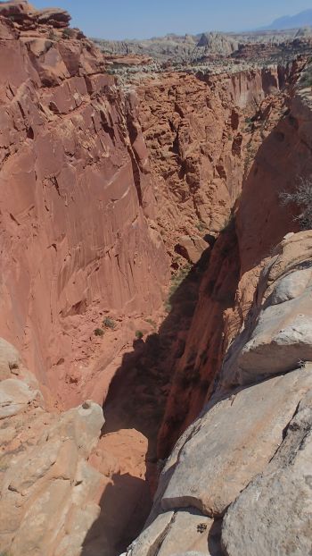
A view down into the Left Fork of Smokestack Canyon. This
is not the fork you will be going down. But it does offer
a good view on the way to the right fork.
Scramble north about 100 feet down into the Left Fork of Smokestack
(ySmokStakLF-Tp). The top of the Left Fork provides a great
view down the main canyon with a huge drop below. The right fork
joins in about 2.5 miles down canyon from here.
After taking a few minutes to enjoy the view from the top of the
left fork walk about 100 feet up the wash and find an easy place to
scramble up out of the wash on the RUC (northeast) side and start
northeast over to the Right Fork of Smokestack Canyon which is about
700 feet north east.
About 300 feet after scrambling up out of the Left Fork of
Smokestack the route will top out (wSmokStakRP-16) where you can
look down toward the Right Fork of Smokestack.
From the top out route find your way about 400 feet northeast down
to the wash at the top of Smokestack Canyon.
Getting down to the head of the right fork is not easy right at the
head. An easier drop in point is about 150 feet up canyon from the
head in a wide sandy section of the wash (wSmokStakRP-17). After
dropping into the wash for the right fork, walk south east down the
wash about 100 feet to the head of the Right Fork
of Smokestack Canyon (ySmokStakRF-Tp). This is where there is a down climb of about 10 feet in a
tight crack.
The Canyoneering / Technical Section:
After down climbing the 10 foot drop at the head of the Right Fork
of Smokestack Canyon (ySmokStakRF-Tp), continue down over two more
drops to scramble over of 6 to 8 feet each.
A little over 100 feet down canyon of the 10 foot crack down
climb is a down climb of about 20 feet in a narrow slot. The first
5 feet is an easy down climb to a log then the last 15 feet can also
be down climbed chimney style. The walls at the bottom bell out
adding a little challenge. For safety, one of the better down
climbers in the group could provide a top belay then down climb
last.
Warning:
Send only one or two people down the 20 foot down climb and
LEAVE someone at the top of the down climb. The person or people
that drop down the down climb first can go evaluate the anchor for
rap 1. If there is insufficient anchor material (rocks), the people
at the top of the down climb can go farm rocks from the top of the
down climb.
Rap 1 (dSmokStak-R1) is about 30 feet down canyon after the 20 foot
down climb. Rap 1 is anchored from a dead man anchor near the top
of the rap. There are no rock features or other natural anchor
options here. Rocks can be farmed from above the down climb just up
canyon to build the dead man anchor in the sand at the top of the
rap (see warning above). Rap 1 drops about 115 feet on a mostly
vertical wall with two major ledges on the way down.
About 150
feet down canyon of rap 1 the canyon jogs right then left. Where
the canyon turns right there is a boulder debris field from rock
fall. Find your way over and through the boulders by scrambling,
down climbing and crawling through whatever route looks fun.
Shortly down canyon, the route veers right again and comes to the
start of a long flat sandy floor along a narrow fault line
(wSmokStakRP-18).
About 200 feet down canyon along the fault
line starts a tight slot that you can down climb / elevator down
about 15 feet to the bottom. There are various logs and choke
stones wedged overhead as you descend down into the tight slot.
The narrow slot is about 300 feet long and starts to get narrower as
it continues down canyon. Large people will not be able to stay on
the floor in the slot and need to stem high and work down canyon
stemming in the wider high area of the slot. On the other end of
the slot the canyon opens up, where a small side drainage joins in
from RDC.
About 175 feet down canyon after the slot opened up is
another short slot. This slot is narrow enough that most people
will want to stem high and avoid going down in.
On the other side
of the short slot is a down climb down into the main canyon where it
joins the left fork (jSmokstakConfl). To exit the right fork and
drop into the main canyon there is a down climb. This down climb is
about 15 feet and will offer a challenge. The down climb is along a
narrow slot but the slot is shaped such that there is little to hang
on to and the down climber is forced out of the slot giving the feel
of exposure. Dragging one arm behind you as you slither down this
drop seems to work well. For safety, one of the better down
climbers in the group could provide a top belay then down climb
last.
After the down climb into the main canyon go left (east) and
continue down canyon in a wide sandy floor.
A little over 100
feet down canyon of the confluence is a narrow slot to drop about 15
feet down into and walk through. The slot is only 40 or feet long
and can optionally be bypassed along ledges above.
After the slot
is more wide open sandy floor to walk for about 300 feet to another
short narrow section to walk through on a sandy floor.
About 100
feet after the second short narrow section, the canyon takes a sharp
left and starts into another narrow section (wSmokStakRP-19). This
narrow section where the canyon takes a left is longer and more
interesting than the two short ones up canyon. Travel is overall
easy along this third narrow section. But rather than walk, you
will need to scramble, do a couple easy down climbs and a couple
easy stemming or gallumping moves. After about 200 feet the narrow
section opens up to a wide sandy floor again. This narrow section
would have a few pools in it if the canyon was full of water but
each would only be about waist deep.
Note:
From the confluence of
the left and right forks down to the start of the third narrow
section, the sides of the canyon look as though there would be
multiple possibilities to escape the canyon if the need should
arise.
About 100 feet after exiting the third narrow section down
canyon of the confluence, will be the start of another narrow
section which is only about 60 feet long. At the other end of this
fourth narrow section will be the top of rap 2.
Rap 2
(dSmokStak-R2) is anchored from a log jammed between the narrow
walls about 20 feet up canyon of the drop. Rap 2 has an awkward
start over a sharp lip and drops about 110 feet. A large portion of
this rappel is free hanging. Other options for anchoring the rap
would be choke stones carefully placed in the S shaped curve near
the top of the drop. Caution, the rock in this area is brittle and
care should be taken when selecting stone based anchor options.
Note / Caution / Warning -----
Rope Groves:
This rappel is such that
rope grooves can develop from rope pull if not set up correctly.
Over time and multiple descents of the canyon, these rope groves can
become quite deep. The rope grooves not only scar and trash the
beauty of the canyon but also start introducing more issues with
getting ropes stuck in them.
Extend Rap Ring OVER the lip:
To
avoid rope grooves being developed when pulling the rope, the anchor
webbing should be extended so the rap ring or rapid is extended over
the lip of the drop. Setting the rap ring over the lip will help
provide a clear pull line and reduce or possibly eliminate rope pull
grooves.
Courtesy Loop for Easier Start:
Extending the rap ring
over the lip of the drop can make starting the rappel very awkward.
A courtesy loop can be set up to make the start of the rappel easier
to start for all but the last person. Tie an extra loop in the
anchor webbing large enough for a hand that sits just above the lip
of the drop (the courtesy loop). The loop for the rap ring can be
clipped to the courtesy loop so the rap ring now sits just above the
lip of the drop. All but the last person can now rappel while the
rap ring is just above the lip of the drop. The last person
rappelling will have the most awkward start. The last person to
rappel will need to unclip the two loops from each other so the rap
ring is now once again below the lip of the drop. The last person
pulls the rope up to them and rigs their descending device into the
rope. The courtesy loop (still in the anchor webbing just above the
lip of the drop) can be used as a hand hold for the last rappeller
as they lower themselves over the lip onto the rappel. The last
person should be cautious and remember to keep their brake hand on
the rope at all times while lowering themselves over the lip of the
drop. After they have slid over the lip of the rappel and lowered
themselves using the courtesy loop they can rappel as usual.
Fireman Belay:
While fireman belays are commonly used, they should
be a standard addition to this method especially for the last
person. On some very awkward rappels the last person will have a
very awkward start filled with its own mental challenges. It is
comforting to know that one of your canyon mates is below watching
you ready to pull the rope if you get into trouble.
After getting
down to the bottom of rap 2, you can take off harnesses etc and
prepare for the hike out since this is the last rap.
Walk and
occasionally scramble east down canyon of rap 2 for about 0.5 miles
to where Smokestack Canyon drops into Chimney Rock Canyon (ySmokStak-Bt).
The Exit:
After getting to Chimney Rock Canyon (ySmokStak-Bt), turn right
(south) and start walking up stream in Chimney Rock Canyon. About
0.5 miles up the wash, a large side canyon will join in from the
right (north) wSmokStakRP-20).
About 0.3 miles after the side canyon look for an easy spot to walk
up to the trail (wSmokStakRP-21).
Follow the trail west as it crosses over various small drainages.
About 0.8 miles along the trail will be a trail junction with a sign
(jChim-Sprg-cyn). The trail sign points the way to Spring Canyon
via Chimney Rock Canyon (back the way you came and to more of the
Chimney Rock loop. Continue right (south) at this junction.
Follow the trail about 0.5 miles back down some switchbacks to the
Chimney Rock trailhead parking area where you started the route.
Downloadable GPX files
available at
BG-Gear Store
(easier than manual entry and a great way to support
Bluugnome).
Waypoint naming convention and map symbol information can be found on the Glossary page.
Elevations are approximate.
BEFORE
manually entering coordinates set your system to WGS84 datum and Lat/Lon hddd.ddddd° coordinate format.
Inconsistent datum's and coordinate formats will result in location errors.
Click to show / expand the list of waypoints below........
| Smokestack 1 - Approach |
- tChimneyRock
Lat/Lon (WGS84): N 38.31570
W -111.30397
Elev: 6,055 Feet
Chimeny Rock Trailhead. Paved parking and a pit toilet.
- wSmokStakRP-01
Lat/Lon (WGS84): N 38.31602
W -111.30372
Elev: NaN Feet
If going up to the top of Smokestackcanyon, leave the main trail here and start walking nortehwest over to a draiange about 400 feet away.
If going down down Chimney Rock Canyon to go to Stone Dagger or A-Door-Able canyons continue eastish on the trail.
- wSmokStakRP-02
Lat/Lon (WGS84): N 38.31726
W -111.30390
Elev: NaN Feet
Route meets a wash here. Turn north east and start walking up the wash.
- wSmokStakRP-03
Lat/Lon (WGS84): N 38.31972
W -111.30242
Elev: NaN Feet
Wash passes some whitish sandstone outcroppings.
- wSmokStakRP-04
Lat/Lon (WGS84): N 38.32190
W -111.30174
Elev: NaN Feet
Wash veers right (east) here going up toward a ravine to the left of a pointy peak. Walk east up the wash to the ravine. As you look east up the wash toward the ravine you should see a pointed peak to the right of the ravine and the cliff leading up to the mesa top to the right of the ravine.
- wSmokStakRP-05
Lat/Lon (WGS84): N 38.32197
W -111.30063
Elev: 6,180 Feet
Bottom of the ravine used to get up onto the mesa.
- wSmokStakRP-06
Lat/Lon (WGS84): N 38.32190
W -111.29868
Elev: 6,480 Feet
The walls of the ravine get higher here and the ravine takes on more of a canyon feel.
- wSmokStakRP-07
Lat/Lon (WGS84): N 38.32152
W -111.29715
Elev: NaN Feet
Near the start of this next steep section will be an up climb of about 10 feet or so. To get up this upclimb you can scramble up the center section or spice it up a little by chimneying up a crack on the LUC (north) side of the ravine.
- wSmokStakRP-08
Lat/Lon (WGS84): N 38.32127
W -111.29624
Elev: 6,635 Feet
Second section of the ravine levels off a bit here near the top of a scree section and is about 250 feet before reaching the obvious head wall of the ravine. This is also the bottom of a side slot on the left (north) that is used to get up onto the mesa above. Travel north up the side slot is mostly easy scrambling with a few easy up climbs of 4 or 5 feet each to get over some of the boulder debris in the slot.
- wSmokStakRP-09
Lat/Lon (WGS84): N 38.32165
W -111.29656
Elev: 6,700 Feet
Side slot tops out here on a large ledge. Veer left (west) along the ledge about 250 feet to get over to a short scramble up climb onto the mesa above.
- wSmokStakRP-10
Lat/Lon (WGS84): N 38.32211
W -111.29722
Elev: 6,800 Feet
Top of a short scramble section to get from the ledge below up onto the mesa.
- wSmokStakRP-11
Lat/Lon (WGS84): N 38.32223
W -111.29489
Elev: NaN Feet
Route up along the ledges levels off slightly as it goes around the point.
- wSmokStakRP-12
Lat/Lon (WGS84): N 38.32262
W -111.29490
Elev: 6,960 Feet
Semi flat easy walking terrain about 150 feet north of the saddel like spot and rocky peak. Continue due north to go toward Smokestack Canyon.
- wSmokStakRP-13
Lat/Lon (WGS84): N 38.32412
W -111.29469
Elev: 6,930 Feet
Route starts down a slightly steeper slope toward rolling desert to the north. Walk down the slope slightly east of north (about 15 degrees true) toward a wash about 0.2 miles away that drops down toward the east. If your travel bearing is too far to the west you will get to the wash where it is shallow and easily missed. Be sure to travel just east of north.
- wSmokStakRP-14
Lat/Lon (WGS84): N 38.32674
W -111.29093
Elev: 6,710 Feet
Drop in the wash about 25 feet high. When you get down to the top of this drop do not go over the drop. Instead leave the wash by scrambling up the LDC (north) side. Then continue north east.
- wSmokStakRP-15
Lat/Lon (WGS84): N 38.32750
W -111.28925
Elev: 6,660 Feet
Top of a canyon like drainage dropping down to the south. From here you can see down that fork and look east down the Left Fork of Smokestack. The Left Fork of Smokestack is not the fork of Smokestack to go down but makes a good visual navigation aid on the way to the Right Fork of Smokestack Canyon. The canyon like fork to the south is shallow and not to interesting looking. The Left Fork of Smokestack to the east is very deep and has a very tall sheer faced LDC wall. Drop down into the Left Fork of Smokestack then continue north east over to the top of the Right Fork.
- ySmokStakLF-Tp
Lat/Lon (WGS84): N 38.32764
W -111.28894
Elev: 6,660 Feet
Top of the Left Fork of Smokestack Canyon. Impressive view down canyon from here with a huge drop below.
- wSmokStakRP-16
Lat/Lon (WGS84): N 38.32836
W -111.28805
Elev: 6,730 Feet
Route between the Left and Right Forks of Smokestack Canyon tops out. Continue about 400 feet north east down to teh wash at the top of the Right Fork of Smokestack Canyon.
- wSmokStakRP-17
Lat/Lon (WGS84): N 38.32923
W -111.28722
Elev: 6,660 Feet
Wide sandy area in the wash that is easy to drop down into just up canyon of the head of the Right Fork of Smokestack.
- ySmokStakRF-Tp
Lat/Lon (WGS84): N 38.32893
W -111.28715
Elev: 6,640 Feet
Top entry of the Right Fork of Smokestack Canyon. There is a down climb of about 10 feet in a tight slot here followed by a couple easy scrambles of 6 to 8 feet each.
|
| Smokestack 2 - The Canyon, Smokestack |
- ySmokStakRF-Tp
Lat/Lon (WGS84): N 38.32893
W -111.28715
Elev: 6,640 Feet
Top entry of the Right Fork of Smokestack Canyon. There is a down climb of about 10 feet in a tight slot here followed by a couple easy scrambles of 6 to 8 feet each.
- dSmokStak-R1
Lat/Lon (WGS84): N 38.32854
W -111.28698
Elev: NaN Feet
Rap 1 - Smokestack Canyon. Anchored from a dead man anchor and drops about 115 feet down a mostly vertical wall with two major ledges on the way down.
- wSmokStakRP-18
Lat/Lon (WGS84): N 38.32770
W -111.28572
Elev: NaN Feet
Start of a long flat sandy floor in a narrow fault line.
- jSmokstakConfl
Lat/Lon (WGS84): N 38.32644
W -111.28515
Elev: 6,375 Feet
Confluence of the left and right forks of Smokestack Canyon. There is a moderately difficult down climb as you exit the right fork of about xx feet.
- wSmokStakRP-19
Lat/Lon (WGS84): N 38.32592
W -111.28321
Elev: 6,335 Feet
Start of the third narrows down canyon of the confluence. This narrow section is lnger than the two previos ones and is about 200 feet long.
- dSmokStak-R2
Lat/Lon (WGS84): N 38.32590
W -111.28217
Elev: 6,320 Feet
Rap 2 - Smokestack Canyon. Anchored from a log about 15 feet back from the drop and drops about 110 feet and mostly free hanging. Please extend the rap ring OVER the lip to avoid rope pull groves. Use a courtesy loop to help with this.
- ySmokStak-Bt
Lat/Lon (WGS84): N 38.32288
W -111.27389
Elev: 6,000 Feet
Bottom exit of Smokestack Canyon wheere it dumps into Chimney Rock Canyon. To exit turn right (south) and wal up stream in Chimney Rock Canyon.
|
| Smokestack 3 - Exit |
- ySmokStak-Bt
Lat/Lon (WGS84): N 38.32288
W -111.27389
Elev: 6,000 Feet
Bottom exit of Smokestack Canyon wheere it dumps into Chimney Rock Canyon. To exit turn right (south) and wal up stream in Chimney Rock Canyon.
- wSmokStakRP-20
Lat/Lon (WGS84): N 38.31922
W -111.28163
Elev: NaN Feet
Large side canyon joins in from the north.
- wSmokStakRP-21
Lat/Lon (WGS84): N 38.31766
W -111.28491
Elev: NaN Feet
On the way out of Chimney Rock Canyon this is an easy spot to walk up to the trail on the south side of the wash. On the way into Stone Dagger or A-Door-Able canyons you will leave the main trail just before here nad route find your way down into the main drainage for Chimney Rock Canyon and continue east down the wash.
- jChim-Sprg-cyn
Lat/Lon (WGS84): N 38.31756
W -111.29826
Elev: 6,300 Feet
Junction for trails for Chimney Rock Loop and a route down to Spring Canyon via Chimney Canyon. To go to Stone Dagger or A-Door-Able canyons follow the trail east contuing into Chimney Rock Canyon not the trail to the south.
- wSmokStakRP-01
Lat/Lon (WGS84): N 38.31602
W -111.30372
Elev: NaN Feet
If going up to the top of Smokestackcanyon, leave the main trail here and start walking nortehwest over to a draiange about 400 feet away.
If going down down Chimney Rock Canyon to go to Stone Dagger or A-Door-Able canyons continue eastish on the trail.
- tChimneyRock
Lat/Lon (WGS84): N 38.31570
W -111.30397
Elev: 6,055 Feet
Chimeny Rock Trailhead. Paved parking and a pit toilet.
|