Canyoneering Route Description
Snotto Canyon - 4A III
Zion National Park, Utah.
07-09-16, 4 people, 1 Day (Travel time in route 14 hours)

Time Required - 8 to 10
Distance - 6.2 miles Total, 0.8 miles Technical
Rappels - 8 Rappels, Longest Rappel 415 feet.
Elevation Range - 6860 - 4280 Feet
Shuttle Required - Yes 21.5 Miles Vehicle -
Passenger
Permit Required - Yes
Rappelling and anchor gear, Ropes and or pull cords for rappels up
to 415 feet and 60 feet of 1 inch webbing for sling placement. Wet
suits not needed.
Snotto Canyon is not a canyon I would recommend.
This route is listed only to offer information about the canyon to those who may be curious.
The
long entry rap is exciting and offers incredible views but the canyon itself
offers little. A better option for this area would be Grotto Canyon which
has a little more to offer and shares the same final rappel as Grotto
Canyon.
The first two rappels of the route are not in Snotto
Canyon itself but instead take you down the side of the mesa to get to the head of
the canyon over 400 feet below. On the hike in you will pass near the top of
Not Grotto Canyon which in contrast does have a head that begins from the
top of the mesa. Keeping this in mind will assist you in getting to the correct canyon.
Not Grotto Canyon begins from the mesa top, is a short and very steep side canyon that drops down
into the mid section of Grotto Canyon. In contrast Snotto Canyon does
not start from the mesa top since you need to rap over 400 feet down to the
head of the canyon, is a long canyon paralleling Grotto and drops into Grotto
near the end just before the final rap which both canyons share.
There are a couple of spots of poison ivy in the canyon but
easily bypassable and may even go un-noticed.
A fun working name of Snotto was thrown out by Hank
Moon before we made the trip. We all laughed at the name and took it to mean
"It's Not Grotto". After descending the canyon we all agreed a better reason
for the name was "It's Not Ok" to do it again because its not good.
To get to the Trailhead
Note:
These directions are for the Stave Springs Trailhead entry.
Other possible starting points would be the East Rim trailhead
or the Weeping Rock trailhead. If Weeping Rock is used there is
no need for a shuttle since you start and finish on the valley
floor where there are shuttle busses. However the approach route will be longer and have a
significant increase in elevation gain.
The last part of the drive into Stave Springs Trailhead is dirt
but is usually passable by passenger car.
From the East Gate of Zion National Park, travel 2.4 miles east
on highway 9 to the turn for North Fork (wEngDP-01) and turn
left (north) onto the North Fork Road. Follow the paved
North Fork Road for 5.3 miles to the turn for the Ponderosa
Ranch (wEngDP-02) and turn left (west) to go into Ponderosa
Ranch.
As you enter the Ponderosa Ranch follow the paved road staying
right at all tuAs you enter the Ponderosa Ranch follow the paved road staying
right at all turns. About 1000 feet after entering
Ponderosa Ranch the paved road will end and a dirt road will
begin (wEngDP-03).
Follow the dirt road 0.3 miles to a junction with a sign for
observation point (wEngDP-04), at this junction continue to the
right / straight ahead to continue west following the sign
toward Observation Point. About 0.22 miles farther is a
Tee in the road (wEngDP-05) where you will turn left (southish)
and not follow the sign to Observation Point. About 100
feet past the left turn is a fork in the road where you will
take the right fork. Drive about 0.6 miles to a triangular
junction (wHiddnDP01) and turn left. In about 200 feet you
will Tee into Pine Street where you will turn right to travel
west on Pine Street. Drive west about 0.5 miles to the
Stave Springs Trailhead (tStaveSpring).
Just before reaching the trailhead is a gate as you re-enter the Zion Park boundary.
You can drive past the gate, but be sure to close the gate
behind you. If there is rain fall the last section of road from the gate to the trail head may be difficult for some vehicles. If that is the case find a convenient place to park near the gate and walk to the trailhead. Keep in mind this is private property and try to be thoughtful when choosing a parking spot.="ContentPlaceHolder9">
The exit vehicle can be parked at the visitor center. Once the
route is complete, take the Zion shuttle to the visitor center
to the exit vehicle.
To leave the Exit Vehicle / Escape Pod
The exit vehicle can be parked at the visitor center. Once the
route is complete, take the Zion shuttle to the visitor center
to the exit vehicle.
GPS coordinate information listed at the bottom. For information about waypoint naming and map symbols, refer to the
Glossary page.

Click the links for maps of the route.
Overview
Map of the drive into the route.
Map of the entire route.
Map of the canyon.
Zoomed in map of canyon entry.
Zoomed in map of lower canyon.
The Approach:
From the Stave Spring Trailhead (tStaveSpring), follow the trail west
about 0.6From the Stave Spring Trailhead (tStaveSpring), follow the trail west
about 0.6 miles to the junction with the East Rim Trail (jStaveEastRimTrl). At the
junction for the East Rim Trail, turn left and continue south on
the East Rim Trail.
About 0.3 miles farther is another
trail junction (jDeerTrpMntTrl). At this junction turn right
and walk south on the Deer trap Mountain Trail.
About 1.1 miles farther will be the junction for the Cable Mountain
trail (jCableMntTrl). Stay left / straight to continue southwest on
the Deertrap Mountain Trail - passing the Cable Mountain junction.
About 0.5 miles farther is
an old junction in the trail
that you will likely never
notice and walk right on by
(jDeerTrapOld1). If
you see this junction stay
left to travel southwest.
If you do not see this
junction keep on walking.g>
Sometime between 2008 and 2014
the trail system has changed. It is unlikely you will
see the old trail veering off to the right since the old trail has been covered and disguised
to allow vegetation to regrow and cover the old trail. The old trail
veers to the right (more west) while the new trail is clear and easy
to follow veering left (more southwest).
About 1.4 miles farther is the top of a switchback (wDeerTrapRP05)
where the trAbout 1.4 miles farther is the top of a switchback (wDeerTrapRP05)
where the trail turns sharp then descends southwest down to a wide
meadow area. It is easy to accidentally get off trail here because
the sharp turn in the trail can be overlooked.
About 0.2 miles farther is
where you would leave the
trail IF you were going to
do Grotto Canyon
(jGrottoCyn). This is at the western
end of a wide open meadow
like area and where
the trail begins to pass
into taller bushes and also
starts to gradually climb.
To continue to Snotto Canyon
stay on the trail and
continue west.
As you continue on the trail
it will ascend up gradually
getting steeper and you will
find some logs placed across
the trail to serve as
stairs.
About 500 feet farther the
trail gets steeper and there
are more logs / stair across
the trail that are now more
closely spaced
(wDeerTrapRP06).
Continue following the trail
as it continues up steeply
for about 500 feet then
levels off for a short
distance then descends down
again toward a huge wide
open flat mesa.
At the bottom of the steep
part of the trail where you
get to the wide open mesa (jSnottoCyn)
you will leave the trail to
go to Sotto Canyon.
Turn right (northwest) and
leave the trail as soon as
you get to the bottom of
this hill and travel north
west. Traveling northwest
from here is a mix of wide
open meadow sections and
large bushes to navigate
through or around. Navigate
about 0.45 miles northwest
(bearing 345 deg.) out to a
point on the mesa where you
can rap down to the head of
Snotto.
Note:
You could just follow the
East Rim trail out to its
end which circles around and
gets to the rap down point
for Snotto but it
is a longer route that way.
As you walk off trail
northwest along the wide
flat mesa you will need to
route find your way through
and around large sections of
vegetation. There is
no one perfect route through
this area but it is pretty
easy to find your way
around. Make your way
about 0.46 miles out to a
point on the mesa
(Snotto01).
Note / Navigation:
Depending on your route
across the mesa top you may
find your self going by the
head of Not Grotto Canyon (yNotGrottoTp).
The head of Not Grotto
canyon starts from the mesa
top and is a short but very
steep side canyon to Grotto
Canyon. If you get here on
the way to Snotto, continue
northwest about 650 feet to
the end of the point where
you can rap off the side
down to the head of Snotto.
When you get out to the end
of the point (Snotto01) you
can look over the side down
over Snotto, Not Grotto and
Grotto Canyons. Looking
carefully just below you and
to the right (southeast) you
can see a dirt and rock ramp
just a little below you.
That ramp will be used as
part of the descent down to
the head of Snotto.
Note:
From the point look over the northeast side
of the point for views of
your route down into Snotto
Canyon. From this spot you
can see Grotto Canyon and
Snotto Canyon running
parallel to one another with
a tall thin fin dividing
them. You can also see
portions of Not Grotto
Canyon running down from the
mesa down into Grotto
Canyon. To get down to the
head of Snotto you will be
rappelling down the slightly
sloped slabby wall you see
below you to get to the
upper end of the long fin
dividing Snotto and Grotto.
Note / Navigation:
The
actual head of Snotto Canyon
over 400 feet below and can
only be accessed by
rappelling off the side of
the mesa. In contrast the
head of Not Grotto Canyon
does begin from the mesa.
Keeping this in mind will
assist you in getting to the
correct canyon.
To get to
rap 1 off
the mesa walk about 110 feet
southeast (back toward the
head of Not Grotto) and
locate a tree to rap down to
a dirt and rock ramp about
30 feet below.
The Canyoneering / Technical Section
Note that the
head of Snotto Canyon
does not start from the
mesa top. You will
need to rap over 400
feet down the side of
the mesa to get down to
the head of Snotto.
Rap 1 (dSnottoR1) is
anchored from a tree about
30 feet back and drops about
20 feet down to a mostly
level dirt area. The anchor
used was not the large
ponderosa right at the rim
but a smaller tree about 30
feet back near a large dead
tree.
From the
bottom of rap 1 walk north
along the ledge then begin
going down the dirt and rock
ramp. The last part of the
ramp will be moderately
steep where crab walking
will be required. The small
tree / large bush at the top
of the crab walk is the
anchor for rap 2. Anchor the
rope for rap 2 from the tree
before the last person comes
down the crab walk section.
At the bottom of the crab
walk section is a small
almost level dirt area where
you will start rap 2.
Rap 2 (dSnottoR2) is
anchored from a large
bush / small tree at the
top of the steep slabby
portion of a ramp and
drops about 415 feet.
The first 360 feet of
rap 2 is down a sloped
slabby wall with lots of
ledges along the way
then the last 40 feet
goes vertical down to a
landing where you can
then scramble down to a
large ledge below.
There are a lot of small
shrubs along the wall
which can potentially
catch a rope. A
retrievable anchor like
the Smooth Operator may
get hung up on the
bushes making a
traditional pull a
better choice here.
 Rap 2 drops about 415 feet
down this sloped wall.
Aim for the tree shown in
the image where you will
then have a vertical drop of
about 35 feet down to a
ledge to complete the
rappel. From the ledge
you can scramble about 65
feet down to the next shelf.
Rap 2 drops about 415 feet
down this sloped wall.
Aim for the tree shown in
the image where you will
then have a vertical drop of
about 35 feet down to a
ledge to complete the
rappel. From the ledge
you can scramble about 65
feet down to the next shelf.
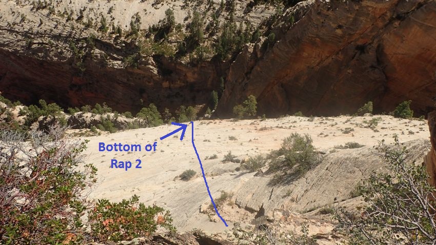
From the bottom of rap 2
(Snotto02) scramble
about 60 feet down a
steeply sloped
outcropping of rock down
to a large open ledge.
Once on the ledge there
are two options to get
to the actual head of
Snotto Canyon.
Option 1:
Walk /
scramble along the ledge
going northwest in the
down canyon direction
for about 250 feet to
where you can easily
walk down to the next
lower ledge. Then turn
and route find your way
along the next lower
major ledge over to the
head of Snotto. Note
that there are a couple
of spots on the traverse
that are narrow and feel
a little sketchy.
To follow option 2
follow the ledge northwest down canyon
a little over 200 feet
(Snotto03 ). Then scramble
down one ledge lower and
begin to walk southeast
back up canyon now on
the lower ledge. Route
find your way a little
over 200 feet to where
you can walk / scramble
down to the head of Snotto. Some route
fining may be needed as
you find your way along
narrow dirt ledges.
There are only a couple
spots that are narrow
and a little sketchy
with most of the route
being pretty straight
forward.
Option 2:
Start
immediately dropping
down the minor ledges
below to a large
ponderosa tree below and
do an optional 60 foot
rappel down to the head
of Snotto. The optional
rappel avoids walking a
couple narrow spots on
the ledge system below.
The head of Snotto
Canyon (ySnottoTp) is
where the head of Snotto
forms and you can travel
down canyon walking and
scrambling down steeply
sloped dirt and rock.
Almost 200 feet down
canyon will be a huge
boulder in the middle of
the canyon and is where
rap 3 starts.
Rap 3 (dSnottoR3) is
anchored from one of
many large rocks to the
left of a huge boulder
in the ravine and drops
about 170 feet to a
large flat rock platform
where rap 4 will be
still well above the
canyon floor. The large
rock platform at the
bottom of rap 3 is not
directly in line with
the fall line of the
rope. The first person
down will need to
carefully traverse RDC (rapellers
left) while rappelling
to get to the platform.
Once there they can
anchor the rope to the
tree there and help
guide others to the
platform.
Rap 4 (dSnottoR4) is
anchored from a small
tree on a large flat
rock platform at the
bottom of rap 3 and
drops about 160 feet to
the canyon floor.
Continue down canyon
with a mix of walking
and scrambling over
short drops for about
700 feet to where the
canyon levels off a
little and becomes more
vegetated.
Canyon starts to level
off a little (Snotto04)
and be easier walking
and becomes more
vegetated. Over the next
0.25 miles is a mix of
wash walking and
scrambling over short
drops. There are also a
couple larger drops that
are bypassed by
scrambling over and
along ledges on the LDC
side. Then another drop
to bypass by scrambling
over and along a ledge
on the RDC side.
Rap 5 (dSnottoR5-6) is
anchored from a tree way
over on the RDC side and
drops about 15 feet.
Rap 6 near the bottom of
rap 5 is anchored from
one bolted hanger and
one bolt with no hanger
and drops a total of
about 20 feet. Only the
first 10 feet need to be
rappelled and the
remainder can be
downclimbed as a stem
style downclimb. We
guessed that the anchors
for rap 6 are part of a
climbers decent for
climbs in the area.
Shortly after is an easy
downclimb to a spot that
holds water and may be
over waist deep if full.
The pool can be
carefully bypassed on
the RDC side but its
slippery. The walk
down canyon about 400
feet to rap 7.
Rap 7 (dSnottoR7) is
anchored from a large
ponderosa and drops
about 100 feet down to
narrow slot where you
then join the Grotto
Canyon route. From the
bottom of the rap walk
about 60 feet over to a
ledge over looking the
final rappel.
Note:
The narrow slot you
rappel down into is a
small ravine and not a
major canyon. The Grotto
Canyon route drops to
this same spot by coming
down the RDC wall here.
Rap
8 (dGrottoR9) (same as
rap 9 for Grotto Canyon) is
anchored from 2 bolted
hangers and drops about
260 feet over an alcove
/ hanging garden area
with the majority of the
rappel being free
hanging. It is possible
to get off rope about 15
feet higher on the
sloped side wall of the
alcove to make the rap a
little shorter.
From the bottom of rap 9
of Grotto Canyon
walk down the sloped
slickrock and over a
short ledge.
The Exit:
To exit
Grotto Canyon follow
northwest along one of
many use trails webbing
around on the LDC (west)
side of the drainage.
The better trails appear
to be quite a ways up
out of the water course.
About 0.26 miles farther
is a dirt road / trail
running west a short
distance over to the
Grotto Bus Stop (wBusStpGrotto).
Ride the bus back to the
visitor center to your
exit vehicle.
Downloadable GPX files
available at
BG-Gear Store
(easier than manual entry and a great way to support
Bluugnome).
Waypoint naming convention and map symbol information can be found on the Glossary page.
Elevations are approximate.
BEFORE
manually entering coordinates set your system to WGS84 datum and Lat/Lon hddd.ddddd° coordinate format.
Inconsistent datum's and coordinate formats will result in location errors.
Click to show / expand the list of waypoints below........
| Snotto Canyon (1) - Drive to Trailhead |
- wEngDP-01
Lat/Lon (WGS84): N 37.23934
W -112.83230
Elev: 5,869 Feet
Turn to the North Fork off Highway 9.
- wEngDP-02
Lat/Lon (WGS84): N 37.27285
W -112.87304
Elev: NaN Feet
Turn left, to the Ponderosa Ranch.
- wEngDP-03
Lat/Lon (WGS84): N 37.27303
W -112.87625
Elev: NaN Feet
Pavement Ends.
- wEngDP-04
Lat/Lon (WGS84): N 37.27489
W -112.88006
Elev: NaN Feet
Continue straight. Sign saying Observation Point.
- wEngDP-05
Lat/Lon (WGS84): N 37.27583
W -112.88405
Elev: NaN Feet
Turn right at Tee in the road. Toward Observation Point.
- wHiddnDP01
Lat/Lon (WGS84): N 37.26880
W -112.89025
Elev: NaN Feet
On the way into Stave Springs Trail Head turn left at this triangular junction and drive about 200 feet to Pine Street. Turn right onto Pine street to travel west to Stave Springs Trailhead.
- tStaveSpring
Lat/Lon (WGS84): N 37.26759
W -112.89948
Elev: 6,450 Feet
Some rangers refer to this as the Stave Springs Trailhead. Have not found official name for it.
|
| Snotto Canyon (2) - Approach to Rap 1 |
- tStaveSpring
Lat/Lon (WGS84): N 37.26759
W -112.89948
Elev: 6,450 Feet
Some rangers refer to this as the Stave Springs Trailhead. Have not found official name for it.
- jStaveEastRimTrl
Lat/Lon (WGS84): N 37.26605
W -112.90779
Elev: 6,390 Feet
Junction to the Stave Springs Trail off of the East Rim Trail.
- jDeerTrpMntTrl
Lat/Lon (WGS84): N 37.26206
W -112.90624
Elev: 6,460 Feet
Junction for the Deertrap Mountain Trail.
- jCableMntTrl
Lat/Lon (WGS84): N 37.25266
W -112.91699
Elev: 6,880 Feet
Trail Junction for the Cable Mountain Trail.
- jDeerTrapOld1
Lat/Lon (WGS84): N 37.24888
W -112.92336
Elev: NaN Feet
Sometime between 2008 when I first visited Hidden Canyon and 2014 the trail system has changed.
This point is where the old and new trails diverge. It is unlikely you will see both trials since the old trail has been covered and disguised to allow vegetation to regrow and cover the old trail. The old trail veers to the right (more west) while the new trail is clear and easy to follow veering left (more southwest).
Continue southwest along the new well defined trail.
- jHiddenCyn
Lat/Lon (WGS84): N 37.24486
W -112.92891
Elev: 6,800 Feet
Leave the trail approximately here to route find your way over to the top of Hidden Canyon. Hidden canyon is about 0.2 miles to the west of this point. There are no helpful landmarks for this point so a GPS is helpful but not manditory.
Leave the trail here and travel west a little over 100 feet to the top of the cliff band. If you left the trail in the correct spot you will find a slope gentle enough to allow you to walk / scramble down to the bottom of the cliff band. If you left in the wrong spot you may be cliffed out and need to wander along the top of the cliff band to find the way down.
- wDeerTrapRP05
Lat/Lon (WGS84): N 37.24216
W -112.93503
Elev: 6,830 Feet
Top of a switchback where the trail turns sharp then descends southwest down to a wide meadow area. It is easy to accidentally get off trail here because the sharp turn in the trail can be overlooked.
- jGrottoCyn
Lat/Lon (WGS84): N 37.24155
W -112.93749
Elev: 6,760 Feet
Here at the western end of a wide open meadow like area the trail begins to pass into taller bushes and also starts to gradually climb. To go to Grotto Canyon, walk to where the trail begins to have bushes on both sides, then veer right and leave the trail and travel northwest about 400 feet to Grotto Canyon.
As you walk over to Grotto there will be some vegetation to wander through to get to where you can scramble down into the canyon. Depending on your route over to the canyon you may scramble in right at the head of the canyon or scramble down in on the RDC side as we did.
Note:
Just past this spot are some logs placed across the trail to serve as stairs. If you are going to Grotto Canyon, leave the trail just before getting to the first log / stair. If you are continuing to Snotto, stay on the trail which will begin to get more steep and have more closely spaced logs / stairs across the trail.
- wDeerTrapRP06
Lat/Lon (WGS84): N 37.24085
W -112.93876
Elev: 6,820 Feet
Trail gets steeper and there are more logs / stair across the trail that are now more closely spaced
- jSnottoCyn
Lat/Lon (WGS84): N 37.24201
W -112.94149
Elev: 6,810 Feet
Bottom of a steep section of trail where it drops down to a large flat mesa. To go to Sotto Canyon turn right and leave the trail as soon as you get to the bottom of this hill and travel north west. Traveling northwest from here is a mix of wide open meadow sections and large bushes to navigate through or around. Navigate about 0.45 miles northwest (bearing 345 deg.) out to a point on the mesa where you can rap down to the head of Snotto.
Note:
You could just follow the East Rim trail out to its end which circles around and gets to the rap down point for Snotto but it is a longer route that way.
- Snotto01
Lat/Lon (WGS84): N 37.24810
W -112.94500
Elev: 6,660 Feet
Out at the end of the point on the mesa where you can look over the side down over Snotto, Not Grotto and Grotto Canyons. Looking carefully just below you and to the right (southeast) you can see a dirt and rock ramp just a little below you. That ramp will be used as part of the descent down to the head of Snotto. To get to the first rap off the mesa walk about 110 feet southeast (back toward the head of Not Grotto) and locate a tree to rap down to a dirt and rock ramp about 30 feet below.
Note:
Look over the northeast side of the point for views of your route down into Snotto Canyon. From this spot you can see Grotto Canyon and Snotto Canyon running parallel to one another with a tall thin fin dividing them. You can also see portions of Not Grotto Canyon running down from the mesa down into Grotto Canyon. To get down to the head of Snotto you will be rappelling down the slightly sloped slabby wall you see below you to get to the upper end of the long fin dividing Snotto and Grotto.
Note / Navigation:
The actual head of Snotto Canyon over 400 feet below and can only be accessed by rappelling off the side of the mesa. In contrast the head of Not Grotto Canyon does begin from the mesa. Keeping this in mind will assist you in getting to the correct canyon.
- dSnottoR1
Lat/Lon (WGS84): N 37.24785
W -112.94470
Elev: NaN Feet
Rap 1 - Snotto Canyon. Anchored from a tree about 30 feet back and drops about 20 feet down to a mostly level dirt area. The anchor used was not the large ponderosa right at the rim but a smaller tree about 30 feet back near a large dead tree.
From the bottom of rap 1 walk north along the ledge then begin going down the dirt and rock ramp. The last part of the ramp will be moderately steep where crab walking will be required. The small tree / large bush at the top of the crab walk is the anchor for rap 2. Anchor the rope for rap 2 from the tree before the last person comes down the crab walk section. At the bottom of the crab walk section is a small almost level dirt area where you will start rap 2.
|
| Snotto Canyon (3) - Canyon and Exit |
- dSnottoR1
Lat/Lon (WGS84): N 37.24785
W -112.94470
Elev: NaN Feet
Rap 1 - Snotto Canyon. Anchored from a tree about 30 feet back and drops about 20 feet down to a mostly level dirt area. The anchor used was not the large ponderosa right at the rim but a smaller tree about 30 feet back near a large dead tree.
From the bottom of rap 1 walk north along the ledge then begin going down the dirt and rock ramp. The last part of the ramp will be moderately steep where crab walking will be required. The small tree / large bush at the top of the crab walk is the anchor for rap 2. Anchor the rope for rap 2 from the tree before the last person comes down the crab walk section. At the bottom of the crab walk section is a small almost level dirt area where you will start rap 2.
- dSnottoR2
Lat/Lon (WGS84): N 37.24817
W -112.94472
Elev: NaN Feet
Rap 2 - Snotto Canyon. Anchored from a large bush / small tree at the top of the steep slabby portion of a ramp and drops about 415 feet. The first 360 feet of rap 2 is down a sloped slabby wall with lots of ledges along the way then the last 40 feet goes vertical down to a landing where you can then scramble down to a large ledge below. There are a lot of small shrubs along the wall which can potentially catch a rope. A retrievable anchor like the Smooth Operator may get hung up on the bushes making a traditional pull a better choice here.
- Snotto02
Lat/Lon (WGS84): N 37.24859
W -112.94414
Elev: 6,280 Feet
Bottom of rap 2. From the bottom of rap 2 scramble about 60 feet down a steeply sloped outcropping of rock down to a large open ledge. Once on the ledge there are two options.
Option 1 is to walk / scramble along the ledge going northwest in the down canyon direction for about 250 feet to where you can easily walk down to the next lower ledge. Then turn and route find your way along the next lower major ledge over to the head of Snotto. Note that there are a couple of spots on the traverse that are narrow and feel a little sketchy.
Option 2 is to start immediately dropping down the minor ledges below to a large ponderosa tree below and do an optional 60 foot rappel down to the head of Snotto. The optional rappel avoids walking a couple narrow spots on the ledge system below.
- Snotto03
Lat/Lon (WGS84): N 37.24921
W -112.94442
Elev: NaN Feet
After completing rap 2 follow the ledge northwest down canyon to here. Then scramble down one ledge lower and begin to walk southeast back up canyon now on the lower ledge. Route find your way a little over 200 feet to where you can walk / scramble down to the head of Snotto. Some route fining may be needed as you find your way along narrow dirt ledges. There are only a couple spots that are narrow and a little sketchy with most of the route being pretty straight forward.
- ySnottoTp
Lat/Lon (WGS84): N 37.24888
W -112.94390
Elev: 6,120 Feet
Top of Snotto Canyon. This is where the head of Snotto forms and you can travel down canyon walking and scrambling down steeply sloped dirt and rock. Almost 200 feet down canyon will be a huge boulder in the middle of the canyon and is where rap 3 starts.
- dSnottoR3
Lat/Lon (WGS84): N 37.24927
W -112.94420
Elev: NaN Feet
Rap 3 - Snotto Canyon. Anchored from one of many large rocks to the left of a huge boulder in the ravine and drops about 170 feet to a large flat rock platform where rap 4 will be still well above the canyon floor. The large rock platform at the bottom of rap 3 is not directly in line with the fall line of the rope. The first person down will need to carefully traverse RDC (rapellers left) while rappelling to get to the platform. Once there they can anchor the rope to the tree there and help guide others to the platform.
- dSnottoR4
Lat/Lon (WGS84): N 37.24942
W -112.94439
Elev: NaN Feet
Rap 4 - Snotto Canyon. Anchored from a small tree on a large flat rock platform at the bottom of rap 3 and drops about 160 feet to the canyon floor. Continue down canyon with a mix of walking and scrambling over short drops for about 700 feet to where the canyon levels off a little and becomes more vegetated.
- Snotto04
Lat/Lon (WGS84): N 37.25121
W -112.94512
Elev: NaN Feet
Canyon starts to level off a little and be easier walking and becomes more vegetated. Over the next 0.25 miles is a mix of wash walking and scrambling over short drops. There are also a couple larger drops that are bypassed by scrambling over and along ledges on the LDC side. Then another drop to bypass by scrambling over and along a ledge on the RDC side.
- dSnottoR5-6
Lat/Lon (WGS84): N 37.25491
W -112.94636
Elev: NaN Feet
Raps 5 and 6 - Snotto Canyon.
Rap 5 anchored from a tree way over on the RDC side and drops about 15 feet.
Rap 6 near the bottom of rap 5 is anchored from one bolted hanger and one bolt with no hanger and drops a total of about 20 feet. Only the first 10 feet need to be rappelled and the remainder can be downclimbed as a stem style downclimb. We guessed that the anchors for rap 6 are part of a climbers decent for climbs in the area.
Shortly after is an easy downclimb to a spot that holds water and may be over waist deep if full. The pool can be carefully bypassed on the RDC side but its slippery.
- dSnottoR7
Lat/Lon (WGS84): N 37.25604
W -112.94645
Elev: NaN Feet
Rap 7 - Snotto Canyon. Anchored from a large ponderosa and drops about 100 feet down to narrow slot where you then join the Grotto Canyon route. From the bottom of the rap alk about 60 feet over to a ledge over looking the final rappel.
The narrow slot you rappel down into is a small ravine and not a major canyon. The Grotto Canyon route drops to this same spot by coming down the RDC wall here.
- dGrottoR9
Lat/Lon (WGS84): N 37.25624
W -112.94638
Elev: NaN Feet
Rap 9 - Grotto Canyon. Anchored from 2 bolted hangers and drops about 260 feet over an alcove / hanging garden area with the majority of the rappel being free hanging. It is possible to get off rope about 15 feet higher on the sloped side wall of the alcove to make the rap a little shorter.
- yGrottoBt
Lat/Lon (WGS84): N 37.25654
W -112.94629
Elev: 4,620 Feet
Bottom of Grotto Canyon just below the final rappel. Follow northwest along one of many use trails webbing around on the LDC (west) side of the drainage. The better trails appear to be quite a ways up out of the water course. About 0.26 miles farther is a dirt road / trail running west a short distance over to the Grotto Bus Stop.
- wBusStpGrotto
Lat/Lon (WGS84): N 37.25908
W -112.95121
Elev: 4,280 Feet
The Grotto shuttle stop on the Zion - Floor of the Valley road.
|