Canyoneering Route Description
Mighty Mouse Canyon - 3A II
Zion National Park, Utah.
08-19-12, 6 people, 1 Day (Travel time in route 7.25 hours)
 Time for combining Deadeye Dick and Mighty Mouse Canyons.
Time Required - Mighty Mouse Only - 5 hours
Allow 7 - 8 hours for doing both Deadeye Dick and Mighty Mouse.
Distance - 7.6 miles Total, 0.2 miles Technical
Rappels - Rappels, Longest Rappel 80 feet.
Elevation Range - 5875 - 5475 Feet
Shuttle Required - No Vehicle - Passenger
can (High Clearance recommended), 4WD if bad roads
Permit Required - No
Rappelling and anchor gear, Ropes and or pull cords for rappels up
to 80 feet and 50 feet of 1 inch webbing for sling placement.
A big Thank You to Kip Marshal for finding then sharing
Mighty Mouse Canyon with us. Thanks Kip!
Mighty Mouse is a very short canyon but offers a punch
in the short distance. Kind of like Mighty Mouse himself,
Little......... but Powerful!
Mighty Mouse Canyon is so short it is likely not
worth the long hike in to do only Mighty Mouse. Luckily it makes a
great canyon to tack onto the end of the Deadeye Dick Canyon route.
Both canyons can be done in one day as a combination route.
Mighty Mouse is a short canyon that will add only an hour to your day if you
decide to do it during your exit of Deadeye Dick. The simplest route
option is to do Deadeye Dick Canyon first then do Mighty Mouse Canyon after
exiting Deadeye Dick.
This route description is written for Mighty Mouse only
and describes doing Mighty Mouse only. If you decide to do both
Deadeye Dick and Mighty Mouse as a combo route, follow the description for
Deadeye Dick all the way to the bottom of Deadeye Dick Canyon. Follow
the Deadeye Dick exit info to the start of the Mighty Mouse route where it
leaves the Virgin River Narrows. At that point refer to the Mighty
Mouse Canyon route description and start reading in the approach section
from where it says "Starting up Out of the Narrows.
Warning:
The dirt portion of the North Fork Road can become impassable with rain.
The road has a lot of clay content and becomes very slick with just a little
rain. Even 4WD vehicles quickly become useless. If there is a
high likelihood of rain, consider opting out of this route that day.
Afternoon showers at some times of the year can create an impassable road in
a very short time. We got stuck overnight only 0.5 miles from pavement
(4WD vehicles included).
Both the Deadeye Dick and Mighty Mouse routes are
outside Zion National Park so no permits are needed. While you do not
need a permit please keep groups to 12 people or less, travel in water
courses or use trails where possible to avoid land wear, pack it in - pack
it out and clean up any un-needed anchor material. The more we take
care of what we have the less likely it is that land management entities
will regulate us.
Both Mighty Mouse and Deadeye Dick Canyons are safe and
easy to descend with natural anchors. Please refrain from adding bolts
to these canyons.
To get to the Trailhead
From the East Gate of Zion National Park, travel 2.4 miles east
on highway 9 to the turn for North Fork (wEngDP-01). Turn Left (north)
toward North Fork.
Drive 5.3 miles on the paved North Fork Road to the
turn for the Ponderosa Ranch. The pavement ends (wBirchHlwDP-01) a few hundred
feet past the turn for the Ponderosa Ranch.
From the turn off for the Ponderosa Ranch continue on the North
Fork Road for 3.1 miles to a large turn
out on the left (west) side of the road which is the trailhead
for Birch Hollow (tBirchHollow).
From the turn off to Birch Hallow continue on the North Fork
road for 3 miles to a turn off (extOrderville) on the left
(west) for the Upper Orderville Trailhead.
From the turn off to the Upper Orderville Trailhead continue on
the North Fork Road for 1.6 miles to a turn off (extCotageWoods)
on the right (east) that goes up to a community called Cottages
in the Woods.
From the turn off to Cottages in the Woods continue on the North
Fork Road for 0.9 miles to a turn off (pkBulloch1) on the left
with a brown road marker signed as 90 and 92.
From the turn off at (pkBulloch1) veer right (northeast) and
continue on the North Fork Road 2.8 miles to a signed turn off (ExtNarowsTopTH)
for the Upper Narrows Trailhead.
Turn left at the turn off and drive west 0.4 miles to a gate
(tNarrowsGate1). Drive through the gate and close it
behind you.
Continue west another 0.4 miles to a fork in the road
(wNarrowsDP-01) with a sign saying left to go to the upper
trailhead for the Virgin River Narrow.
Turn left at the fork and drive about 700 feet to the upper
trailhead for the Virgin River Narrows (tNarrowsTop). Park here.
To leave the Exit Vehicle / Escape Pod
No exit vehicle is needed. This is done as a loop route.
GPS coordinate information listed at the bottom. For information about waypoint naming and map symbols, refer to the
Glossary page.

Click the links for maps of the route.
Map Over view of the Drive to the Trailhead.
Map Zoomed in for First part of Drive.
Map Zoomed in of last part of drive and first part of Approach.
Map Zoomed last part of Approach and Technical Section.
The Approach:
From Upper Narrows
Trailhead (tNarrowsTop)
follow the the trail /
dirt road southwest
along the Virgin River.
About 1.3 miles down the
road will be a small
building on the left
right next to the road
(wNarwsBuild-1).
Continue down the road /
trail for 1.1 miles to a
meadow on the left
(south) side with an old
broke down cabin about
100 feet from the road.
The cabin is called
Bulloch's Cabin (sBullochsCabin).
The meadow and the cabin
sit at the end of a
drainage dropping down
into the narrows from
the left (south) Shortly after Bulloch's
Cabin the road fades
away and you will be
hiking a series of trail
and water course as you
continue down the Virgin
River Narrows.
Note:
From Bulloch's Cabin is
where you start the map
and the terrain for
navigation.
0.6 miles past Bulloch's
Cabin is another
drainage joining in from
the south
(wDeadeyeRP-01).
Pass this drainage by
and continue west down
the Narrows.
0.4 miles farther is the
bottom of the second
side
drainage(wDeadeyeRP-02)
on the left (south) side
downstream of Bulloch's
Cabin. If you were
headed up to Deadeye
Dick Canyon this is the
drainage you would start
up. To continue
down to Mighty Mouse
Canyon stay in the
Virgin River and
continue downstream.
About 0.5 miles down
canyon the river will
make a big bend to the
right almost making a a
full U-turn. At
the U-Turn bend the
river goes from going
south to almost going
north. At the apex
of this bend (jMightMouse) on the RDC
(north) side are some
large obvious rock
outcroppings.
Note:
If you go too far and
pass this bend you will
get to a side canyon on
the right (north) about
1000 feet down canyon of
the climb up spot.
The canyon on the right
is the bottom of Mighty
Mouse. If you get
to the bottom of Mighty
Mouse just turn around
and walk about 1000 feet
back upstream to the
climb out spot with the
outcroppins.
Starting up Out
of the Narrows:
From the apex of the
bend (jMightMouse) walk
up a steep dirt slope
then scramble up onto
the ridge.
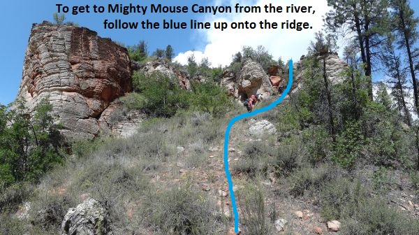
To leave the Virgin River and start up to Mighty Mouse Canyon follow the blue line shown to get up onto the ridge.
As you get to the top of
the dirt hill there will
be a section of
sandstone to upclimb /
scramble up about 25
feet. The scramble
is easy with lots of
features as you scramble
up a chute like section.
Be careful of lots of
loos stuff and check
what you are grabbing
ahold of.
At the top of the
scramble (wMightyMRP-01)
you will be in a flat
dirt area an up on the
ridge near the
outcroppings you could
see from the river.
After the scramble up
follow northwest up the
ridge though light brush
with large patches of
crypto biotic soil
around. As always,
STAY OFF THE CRYPTO.
About 300 feet up the
ridge scramble up a
slick rock slope to a
highpoint on the ridge
(wMightyMRP-02) where
the ridge levels off.
From the highpoint
continue northwest along
the ridge about 400 feet
to a saddle
(wMightyMRP-03).
Between the highpoint
and the saddle is one
section to scramble
down. There is
still large areas of
crypto, please try to
avoid walking on it.
From the saddle continue
northwest in the same
direction over to the
top of a steep slope
about 300 feet away.
The slope runs down into
the top of Mighty Mouse.
Route find your way a
little over 200 feet
down the steep dirt
slope continuing
northwest down into the
Mighty Mouse drainage.
At the bottom of the
slope you are in the top
of Mighty Mouse Canyon (yMightyMouseTp).
The Canyon:
After dropping into
Mighty Mouse (yMightyMouseTp)
turn left and walk south
down canyon. After
a short distance you
will start to see
sandstone pop out and
the canyon begin before
you.
On the way to rap 1 is a
downclimb of about 15
feet over a chokestone
that would be overall
easy but is made
difficult by very slick
rock. Be careful
on this drop.
Rap 1 (dMightyMR1) is a
short distance into the
sandstone section and
about 150 feet down
canyon of the drop in.
From the top of rap 1
there is an interesting
arch down canyon level
with the top of rap 1.
Rap 1 is anchored from a
large chokestone at the
top of the drop that
feels like it could be
pulled free if care is
not taken. Rap 1
drops about 35 feet with
the last 15 or so being
vertical.
At the bottom of rap 1
you are in a very pretty
slot that is short with
a downclimb of about 8
feet as the slot ends.
Where the slot ends you
are in back in a wide
dirt bottom wash with
trees and bushes.
Rap 2 (dMightyR2) is
about 350 feet down
canyon of rap 1 and is
anchored from a tree at
the top of the drop.
Rap 2 drops about 80
feet down a vertical
wall into a deep slot.
Rap 3 is about 50 feet
down canyon of rap 2 and
is anchored RDC from a
pinch point between a
boulder and the canyon
wall. The start of
rap 3 is awkward as it
goes over the boulder
with some loose sand to
make it slick before
going free hang for a
few feet. Rap 3
drops a total of 50 feet
with the lower portion
on a slightly sloped
wall.
Rap 4 (dMightyMR3-4) is
about 50 feet down
canyon of rap 3, can be
anchored from rocks or
logs and drops about 20
feet. Rap 4 can be
downclimbed through a
rabbit hole on the LDC
side but be careful
since the rock is very
slick here.
After rap 4 walk about
250 feet down to the
Virgin River at the end
of Mighty Mouse Canyon (yMightyMouseBt).
The Exit:
From the bottom of
Mighty Mouse Canyon (yMightyMouseBt)
turn left and walk east
back up the Virgin River
4.1 miles back to the
trailhead where you left
your car (tNarrowsTop).
Downloadable GPX files
available at
BG-Gear Store
(easier than manual entry and a great way to support
Bluugnome).
Waypoint naming convention and map symbol information can be found on the Glossary page.
Elevations are approximate.
BEFORE
manually entering coordinates set your system to WGS84 datum and Lat/Lon hddd.ddddd° coordinate format.
Inconsistent datum's and coordinate formats will result in location errors.
Click to show / expand the list of waypoints below........
| Mighty Mouse (1) - Drive in to Trailhead |
- wEngDP-01
Lat/Lon (WGS84): N 37.23934
W -112.83230
Elev: 5,869 Feet
Turn to the North Fork off Highway 9.
- wEngDP-02
Lat/Lon (WGS84): N 37.27285
W -112.87304
Elev: NaN Feet
Turn left, to the Ponderosa Ranch.
- wBirchHlwDP-01
Lat/Lon (WGS84): N 37.27620
W -112.87358
Elev: NaN Feet
Paved road turns to Dirt road.
- wBirchHlwDP-02
Lat/Lon (WGS84): N 37.30654
W -112.86085
Elev: NaN Feet
Dirt road / ATV trail leaves main road. Follow this to start an alternate route into Birch Hollow.
- tBirchHollow
Lat/Lon (WGS84): N 37.30973
W -112.85655
Elev: 6,740 Feet
Trailhead for Birch Hollow. It is a very large turn out on the west side of the road.
- extOrderville
Lat/Lon (WGS84): N 37.33710
W -112.83050
Elev: NaN Feet
Turn off for Orderville from the North Fork road. 11.4 miles from highway 9.
- extCotageWoods
Lat/Lon (WGS84): N 37.35044
W -112.83240
Elev: NaN Feet
Turn off of the North Fork Road to go to Cattages in the Woods community.
- pkBulloch1
Lat/Lon (WGS84): N 37.35896
W -112.84125
Elev: 6,745 Feet
Turn off of the North Fork Road to get to the start point for the Bulloch Canyon approach route. Road sign post labeled as 90 and 92.
- ExtNarowsTopTH
Lat/Lon (WGS84): N 37.39057
W -112.82569
Elev: NaN Feet
Turn off of the North Fork road to drive down to the upper trailhead for the Narrows.
- tNarrowsGate1
Lat/Lon (WGS84): N 37.38990
W -112.83293
Elev: 5,900 Feet
Gate near Chamberlins Ranch on the way to the upper trailhead for the narrows. Close the Gate Behind You.
- wNarrowsDP-01
Lat/Lon (WGS84): N 37.38694
W -112.83844
Elev: NaN Feet
Turn left here where the sign says to trun to the Narrows Trailhead.
- tNarrowsTop
Lat/Lon (WGS84): N 37.38524
W -112.83897
Elev: 5,875 Feet
Top trailhead for the Narrows. This is also the location for the Zero Mile Mark on Zion Adventure Companies Narrows Map.
|
| Mighty Mouse (2) - Approach |
- tNarrowsTop
Lat/Lon (WGS84): N 37.38524
W -112.83897
Elev: 5,875 Feet
Top trailhead for the Narrows. This is also the location for the Zero Mile Mark on Zion Adventure Companies Narrows Map.
- extNarwSrtCtBt
Lat/Lon (WGS84): N 37.37806
W -112.84739
Elev: NaN Feet
Bottom end of a road that can be taken down into the Narrows farther down than the standard trailhead. Need 4WD to handle washed out section. Bank owned land an may be illegal to use this road.
- wNarwsBuild-1
Lat/Lon (WGS84): N 37.37737
W -112.85367
Elev: NaN Feet
Small building.
- sBullochsCabin
Lat/Lon (WGS84): N 37.37092
W -112.86658
Elev: 5,645 Feet
Bulloch's Cabin. An old broke down cabin in a meadow just off the road on the south side.
- wDeadeyeRP-01
Lat/Lon (WGS84): N 37.37129
W -112.87614
Elev: NaN Feet
A drainage joining in from the LDC (south) side. This is 0.6 miles down stream from Bulloch's Cabin. This is the 3 mile mark down from the upper trailhead.
- wDeadeyeRP-02
Lat/Lon (WGS84): N 37.37016
W -112.88270
Elev: NaN Feet
Bottom of the second side drainage on the south side down stream of Bulloch's Cabin. To approach Deadeye Dick leave the narrows here and travel south up this drainage. To continue down the Narrows toward Mighty Mouse stay in the Narrows and continue downstream.
- jMightMouse
Lat/Lon (WGS84): N 37.36940
W -112.88693
Elev: 5,510 Feet
To get up to Mighty Mouse Canyon leave the Virgin River here and scramble up to the ridge line to the RDC (north) side. The scramble route is slightly up canyon of a large obvious outcropping at the apex of the bend in the river here.
- wMightyMRP-01
Lat/Lon (WGS84): N 37.37000
W -112.88706
Elev: 5,540 Feet
Top of a 25 foot scramble as you get up onto the ridge. The upclimb / scramble is easy with lots of features as you go up a chute like section. Be careful of loose rock though.
- wMightyMRP-02
Lat/Lon (WGS84): N 37.37057
W -112.88768
Elev: 5,680 Feet
High point on the ridge on the way up to Mighty Mouse.
- wMightyMRP-03
Lat/Lon (WGS84): N 37.37147
W -112.88837
Elev: 5,690 Feet
A saddle along the ridge on the way to Mighty Mouse.
- yMightyMouseTp
Lat/Lon (WGS84): N 37.37286
W -112.88907
Elev: 5,675 Feet
Top of Mighty
|
| Mighty Mouse (3) - Canyon and Exit |
- yMightyMouseTp
Lat/Lon (WGS84): N 37.37286
W -112.88907
Elev: 5,675 Feet
Top of Mighty
- dMightyMR1
Lat/Lon (WGS84): N 37.37258
W -112.88935
Elev: NaN Feet
Rap 1 - Mighty Mouse Canyon. Anchored from a chokestone (which feels loose) and drops about 35 feet with teh last 15 feet being on a vertical wall. Down canyon of rap 1 is a very pretty but short slot area with a downclinmb of about 8 feet at the end.
- dMightyMR2
Lat/Lon (WGS84): N 37.37181
W -112.88972
Elev: 5,570 Feet
Rap 2 - Mighty Mouse Canyon. Anchored from a tree at the top of the drop and drops about 80 feet down a vertical wall into a deep slot.
- dMightyMR3-4
Lat/Lon (WGS84): N 37.37152
W -112.88979
Elev: NaN Feet
Raps 3 and 4 - Mighty Mouse Canyon.
Rap 3 anchored RDC from a pinch point between a boulder and the canyon wall. Rap 3 drops a total of 50 feet with the top being an awkward start over the boulder and the lower portion on a slightly sloped wall.
Rap 4 is the place for this waypoint and is about 50 feet down canyon of rap 3. Rap 4 can be anchored from rocks or logs and drops about 20 feet. Rap 4 can be downclimbed through a rabbit hole on the LDC side but be careful since the rock is very slick here.
- yMightyMouseBt
Lat/Lon (WGS84): N 37.37089
W -112.88965
Elev: 5,475 Feet
Bottom of Mighty Mouse Canyon where it dumps into the Narrows.
- jMightMouse
Lat/Lon (WGS84): N 37.36940
W -112.88693
Elev: 5,510 Feet
To get up to Mighty Mouse Canyon leave the Virgin River here and scramble up to the ridge line to the RDC (north) side. The scramble route is slightly up canyon of a large obvious outcropping at the apex of the bend in the river here.
- tNarrowsTop
Lat/Lon (WGS84): N 37.38524
W -112.83897
Elev: 5,875 Feet
Top trailhead for the Narrows. This is also the location for the Zero Mile Mark on Zion Adventure Companies Narrows Map.
|