Canyoneering Route Description
Shillelagh Canyon - Left (west) Fork - 3A I
North Wash, Utah.
05-29-10, 2 people, 1 Day (Time Unknown) - Did all seven Irish
Canyons in a day with this being one of them.
10-21-12, 1 person, 1 Day (Time Unknown) - Combined with an upclimb
of the Right Fork of Blarney Canyon.

04-06-13, 2 people, 1 Day (Time Unknown) - Did all seven Irish
Canyons in a day with this being one of them.
Time Required - 2 to 3 hours
Distance - 2.6 miles Total, 0.7 miles Technical
Rappels - 2 Rappels, Longest Rappel 70 feet.
(max rap only 60 feet if anchor webbing extended properly)
Elevation Range - 4510 - 4900 Feet
Shuttle Required - No Vehicle - Passenger
Permit Required - No
Rappelling and anchor gear, Ropes and or pull cords for rappels up
to 70 feet and 50 feet of 1 inch webbing for sling placement.
The Right Fork of Shillelagh is similar to the Left Fork in
that the technical section is very short. Enjoy the two raps near the head
and take your time there since those are the only raps. Down canyon are a
few easy down climbs and a very pretty and long narrows near the end of the
canyon.
At the time of this writing there were no well defined
trails traversing from the Right Fork to the Left Fork of Shillelagh Canyon.
There are obvious areas that have seen foot traffic but nothing lends itself
to a well defined and easy to follow trail. The 0.32 miles between the
tops of the two forks is easy travel and forgiving terrain but you will need
to do your own route finding.
To get to the Trailhead
The Left (west) Fork of Shillelagh Canyon uses part of the same
approach as Blarney Canyons.
From the junction of Utah highways 276 and 95, drive South on
highway 95 about 1.5 miles to a turn off to a short dirt road (extBlarney).
The road drives straight back from the highway about 300 feet
then turns left to drop down into the wash. Park after the 300
feet of straight road before it turns (pkBlarney). Optionally
you can park out on the road and walk the 300 feet in.
To leave the Exit Vehicle / Escape Pod
No exit vehicle is needed. This is done as a loop route.
GPS coordinate information listed at the bottom. For information about waypoint naming and map symbols, refer to the
Glossary page.

Click the links for maps of the route.
Map of the entire route.
The Approach:
The Approach:
From where you parked on the dirt road (pkBlarney) you will see the
dirt road continue on into the wash that leads up into Blarney.
Walk north west across the road and follow a faint path up out of
the wash the road was going up. You will find yourself on a high
spot between the wash the road was following and another drainage on
the right (south west).
Continue north west between these two drainages. About 350 feet
from the car will be the base of a slick rock slope
(wBlarneyRP-01). Scramble north up the sandstone slope to gain
access to the ridge running between the two drainages. After about
375 feet the slope levels off a little but still continues
climbing.
After another 450 feet is a smooth sandstone high point along the
ridge (wBlarneyRP-02). From this smooth high point is a view of a
huge rock face ahead about 500 feet away.
Then another 300 feet is another high point that has more of a rock
out cropping look (wBlarneyRP-03). Skirt around the left (west)
side of the high point and continue toward the huge rock face.
After another 200 feet you will be at the base of the huge rock face
(wBlarneyRP-04). Follow a well worn trail around the left (west)
side of the rock face.
Another 550 feet will be a scramble up a section of slick rock
(wBlarneyRP-05). At the top of the slick rock the trail continues
north and is still easy to follow. The trail here is following the
rim of the canyon on your right which is a side drainage of Blarney.
About another 350 feet will be another slick rock slope
(wBlarneyRP-06) to scramble up about 50 or 60 feet high. A cairn
may be at the top to help guide you. At the top the trail continues
still roughly following the rim on the right (east) side.
After the last slick rock scramble follow the well worn path about
0.3 miles to a junction in the trail (jBlarnyShilela). To the left
(north west) leads to the Right Fork of Shillelagh Canyon. To the
right (north east) leads to the Left Fork of Blarney Canyon.
From the junction veer left (north west) and follow the path toward
the head of the Right (east) Fork of Shillelagh Canyon.
About 700
feet from the junction there is a faint spur trail branching off
left (northwest) leading down into the Right Fork of Shillelagh
Canyon. Stay on the more well worn path
and continue north another 200 feet where the trail turns left and
heads northwest to an easy walk down into the Right (east) Fork of
Shillelagh (jShillelaghRF).
To continue to the Left Fork of Shillelagh or to the Short End of
the Stick Route continue west crossing over the wash and walk up the
slope on the other side.
Note:
At the time of this writing there were no well defined trails
traversing from the Right Fork to the Left Fork of Shillelagh
Canyon. There are obvious areas that have seen foot traffic
but nothing lends itself to a well defined and easy to follow trail.
The 0.32 miles between the tops of the two forks is easy travel and
forgiving terrain but you will need to do your own route finding.
From where you cross over the Right Fork it is about 0.32 miles on a
bearing of 286 degrees to where you drop into the Left Fork of
Shillelagh. A compass or GPS can be handy as there are few
obvious land marks. As you travel through the rolling desert
please make an effort to stay of of crypto biotic soils. You
can further reduce impact by trying to walk in small water ways when
they are going where you want to go.
About 0.13 miles from where
you left the Right Fork is a
dark red outcropping of rock
that stands out and is
visible for a distance.
This makes a good land mark
to aim for as it is directly
in line with your travel
route.
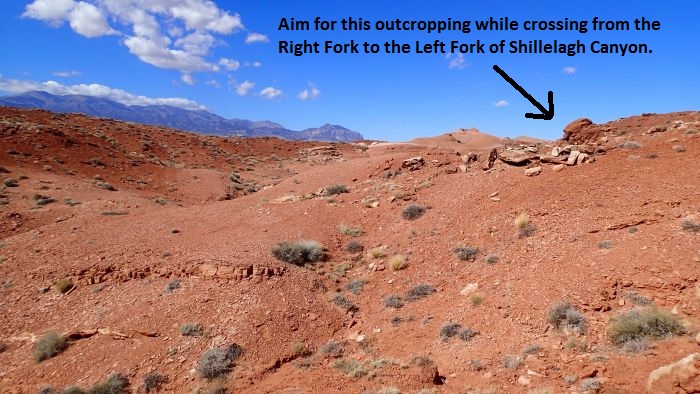 Aim for this outcropping
when you see it. This
outcropping is inline with
the route between the Right
Fork and the Left Fork of
Shillelagh Canyon.
Aim for this outcropping
when you see it. This
outcropping is inline with
the route between the Right
Fork and the Left Fork of
Shillelagh Canyon.
From the outcropping
continue on the bearing of
286 degrees for 0.2 miles to
where you easily drop down
into a wide open wash in the
Left Fork (wShillRp-22).
Then turn left and walk
southwest down the wash for
about 400 feet to the head
of the Left Fork of
Shillelagh Canyon (yShilelahLFkTp).
The Canyoneering / Technical Section:
At the head of the
Left Fork of Shillelagh
Canyon (yShilelahLFkTp)
is a drop of about 30
feet that is downclimbed
on the LDC side and
sandy sloped ledges.
About 300 feet down
canyon is the start of a
150 foot long narrow
section (wShillRp-23).
An easy stem style down
climb is at the
beginning of the narrows
and an easy 4 foot down
climb is near the end of
the narrows.
About 500 down canyon is
a down climb of about 6
feet shortly before
reaching the top of rap
1.
Rap 1 (dShillLtFkR1-2)
is anchored from a
boulder embedded in the
wash about 12 feet back
from the lip of the
drop. Rap 1 drops about
25 feet to a large
shelf. Rap 1 is
overhung so it can be a
bit akward.
Rap 2 is on the other
side of the shelf below
rap 1. There is a
short downclimb to get
down to the anchor for
rap 2. Rap 2 is
anchored from large rock
in a pothole. Rap 2 has
a rope travel of about
70 feet from the anchor
to the ground. But
the webbing here should
be extended to keep from
adding rope grooves to
the sandstone which will
make the drop about 60
feet.
About 100 feet down
canyon of rap 2 is a
stemming / elevator like
downclimb of about 15
feet into a narrow
section to walk through.
Continuing down canyon
are a few boulders to do
downclimb over that are
about 4 to 8 feet each
to break up the walking.
About 0.18 miles down
canyon of rap 2 is a
side drainage
(wShillRp-24) joining in
from RDC (northwest).
About 300 feet down
canyon is the start of
another narrow section
(wShillRp-25).
Note:
This is where you can
easily escape the canyon
on the LDC (southeast)
side if you want to
climb up to the top of
the canyons by
scrambling the slick
rock.
The narrow section is an
easy walk with a few
short easy down climbs
to break things up.
This narrows gets is a
scenic treat as it gets
deep and narrow but
still easy to walk in.
This narrows is about
0.24 miles to where it
opens up wide again
(wShillRp-26).
About 325 feet after the
narrows widens out is
the confluence of the
Right and Left Forks of
Shillelagh Canyon (yShillelaghBt).
The Right Fork joins in
here from the LDC side.
The Exit:
From the Junction of the 2 forks of Shillelagh Canyon walk the wash
0.4 miles back to the road (tShillelaghBt). Next walk south 0.2
miles back to where you parked near the bottom of Blarney Canyon.
Downloadable GPX files
available at
BG-Gear Store
(easier than manual entry and a great way to support
Bluugnome).
Waypoint naming convention and map symbol information can be found on the Glossary page.
Elevations are approximate.
BEFORE
manually entering coordinates set your system to WGS84 datum and Lat/Lon hddd.ddddd° coordinate format.
Inconsistent datum's and coordinate formats will result in location errors.
Click to show / expand the list of waypoints below........
| Shillelagh Left Fork (1) - Approach |
- extBlarney
Lat/Lon (WGS84): N 38.02044
W -110.54493
Elev: 4,510 Feet
Exit for the dirt road into the bottom of Blarney Canyon.
- pkBlarney
Lat/Lon (WGS84): N 38.02120
W -110.54479
Elev: 4,530 Feet
Park here on the dirt road a short distance from the highway to start Blarney Canyon or Shillelagh Canyon.
- wBlarneyRP-01
Lat/Lon (WGS84): N 38.02194
W -110.54538
Elev: NaN Feet
Base of a sand stone slope leading up to the ridge between two drainages.
- wBlarneyRP-02
Lat/Lon (WGS84): N 38.02397
W -110.54431
Elev: NaN Feet
Smooth sand stone high point on the ridge.
- wBlarneyRP-03
Lat/Lon (WGS84): N 38.02484
W -110.54440
Elev: NaN Feet
Another high point along the ridge that looks more like a rock out cropping.
- wBlarneyRP-04
Lat/Lon (WGS84): N 38.02542
W -110.54441
Elev: NaN Feet
At the base of a huge rock face. Travel around the left (west) side of the rock face following a well worn trail.
- wBlarneyRP-05
Lat/Lon (WGS84): N 38.02664
W -110.54412
Elev: NaN Feet
Scramble up a section of slick rock to find where the trail continues.
- wBlarneyRP-06
Lat/Lon (WGS84): N 38.02745
W -110.54399
Elev: 4,830 Feet
Another slick rock slope to scramble up to find where the trail continues again.
- jBlarnyShilela
Lat/Lon (WGS84): N 38.03085
W -110.54269
Elev: 4,855 Feet
Junction where the trail forks for either the West Fork of Blarney to the right (north east) or the East Fork of Shillelagh to the left (north west).
- wShillRp-01
Lat/Lon (WGS84): N 38.03266
W -110.54192
Elev: 4,850 Feet
Leave the trail here to drop into Right Fork of Shillelagh with an easy down climb.
- jShillelaghRF
Lat/Lon (WGS84): N 38.03326
W -110.54193
Elev: 4,875 Feet
Trail drops down into the Right Fork of Shillelagh here. Turn south and walk down the wash to drop into the Right Fork of Shillelagh. Or continue west accross the wash and up the otehr side to continue over to the Left (west) Fork of Shillelagh Canyon or the Short End of the Stick route.
- wShillRp-21
Lat/Lon (WGS84): N 38.03381
W -110.54420
Elev: 4,900 Feet
Outcropping of dark red rock that stands out from a distance and makes a good landmark on the route between forks of the Shillelaghs since it is directly inline with the route.
- wShillRp-22
Lat/Lon (WGS84): N 38.03452
W -110.54750
Elev: 4,840 Feet
This is where the route from Right Fork to Left Fork Shillelagh drops to the Left Fork wash about 400 feet up canyon of the head. It is an easy walk down into the wash here.
- yShilelahLFkTp
Lat/Lon (WGS84): N 38.03380
W -110.54853
Elev: 4,815 Feet
Top entry for left (west) fork of Shillelagh Canyon. There is a 30 foot drop here that can be down climbed LDC along sloped sandy ledges.
|
| Shillelagh Left Fork (2) Exit and Canyon |
- yShilelahLFkTp
Lat/Lon (WGS84): N 38.03380
W -110.54853
Elev: 4,815 Feet
Top entry for left (west) fork of Shillelagh Canyon. There is a 30 foot drop here that can be down climbed LDC along sloped sandy ledges.
- wShillRp-23
Lat/Lon (WGS84): N 38.03361
W -110.54950
Elev: 4,800 Feet
Start of a 150 foot long twisty narrows.
- dShillLtFkR1-2
Lat/Lon (WGS84): N 38.03242
W -110.55051
Elev: 4,750 Feet
Raps 1 and 2 - Shillelagh Left Fork.
Rap 1 anchored from a boulder embedded in the wash about 12 feet back from the rap and drops about 25 feet to a large shelf below and is a little awkward due to it being overhanging.
Rap 2 is anchored from a large rock in a pothole on the other side of the shelf below rap 1 and drops about 70 feet feet. If you extend the webbing to protect the sandstone (which you should) the rap should only be about 60 feet.
- wShillRp-24
Lat/Lon (WGS84): N 38.03008
W -110.55187
Elev: NaN Feet
Side draiange joining in from RDC (northwest).
- wShillRp-25
Lat/Lon (WGS84): N 38.02924
W -110.55162
Elev: NaN Feet
Start of another narrow section with a few 4 to 6 foot downclimbs. Also this is where you can escape on the LDC (southeast) side of the canyon if you want to try to go up to the top of the canyons from here.
- wShillRp-26
Lat/Lon (WGS84): N 38.02655
W -110.54960
Elev: 4,550 Feet
Lower end of the narrows just before reaching the confluence with the Right Fork of Shillelagh.
- yShillelaghBt
Lat/Lon (WGS84): N 38.02573
W -110.54944
Elev: 4,560 Feet
Bottom exit for both fork of Shillelagh Canyon. Junction of the right and left forks of Shillelagh Canyon.
- tShillelaghBt
Lat/Lon (WGS84): N 38.02088
W -110.54842
Elev: 4,510 Feet
Bottom trailhead for Shillelagh Canyon where the wash meets the road.
|