Canyoneering Route Description
Ponderosa Canyon - 3A(B) I
North Wash, Utah
03-23-19, 6 people, 1 Day (Travel time in route 7 hours)
 time includes both Who Knew and Ponderosa Canyons.
Time Required - 2 to 3 hours
Distance - 1.2 miles Total, 0.2 miles Technical
Rappels - 1 Rappels, Longest Rappel 150 feet.
Need 220ft rope or 70ft and 150ft ropes tied together due to
long anchor set-back.
Elevation Range - 4420 - 4710 Feet
Shuttle Required - No Miles Vehicle -
Passenger
Permit Required - No
Rappelling and anchor gear, Ropes and or pull cords for rappels up
to 220 feet and 40 feet of 1 inch webbing for sling placement.
The longest rap uses about 150 feet of rope but the anchor is
set-back about 70 feet using a total of about 220 feet of rope.
To keep from hauling a long rope, we used a 70 foot rope extended
from the anchor to the top of the drop then tied a 150 foot rope to
the 70 foot rope to rappel on. Keep in mind you will still
need a pull cord of at least 220 feet.
Optionally you could not use a pull cord at all and ask a friend to
stay at the top, release the rope when everyone else is down then
rim walk the LDC (east) side of the canyon and scramble down into
the canyon below rap 1.
Wetsuits may be a good idea if there has been recent rains and cool
weather. If dry conditions and warmer weather, wetsuits should be
left at the car. Most water is avoidable but there is a chance you
will need to or accidentally slip into water.
Friends told me they went to check out Ponderosa Canyon and
thought it was more enjoyable than satellite imagery suggested it would be.
Ponderosa is a short canyon (some may call it a micro canyon) good for killing
some time, but I would not rate this a destination route. If you are
looking for more excitement and still want a short route in the same area, the
nearby Bushwax Canyon would be a better choice.
The pictures from 2019 are from a route combining both
Who Knew and Ponderosa Canyons following a route between the two not
described in either of the routes here. The route between the two was from
the bottom of Who Knew, we went down Butler Canyon about half mile then
found a weakness to scramble up out of Butler and find our way to the head
of Ponderosa. If you also want to combine the routes, a better and shorter
way to do this would be to follow the exit for Who Knew up to the top of
Sandthrax Canyon, then route find from the top of Sandthrax Canyon about 0.5
miles south to the top of Ponderosa Canyon.
To get to the Trailhead
From the junction of highways 276 and 95, travel south east on
95 for 2.6 miles to where the bottom of Ponderosa Canyon meets
the road (pkPonderosa) on the left (north). There is no
obvious parking spot. Park anywhere room allows.
To leave the Exit Vehicle / Escape Pod
No exit vehicle is needed. This is done as a loop route.
GPS coordinate information listed at the bottom. For information about waypoint naming and map symbols, refer to the
Glossary page.

Click the links for maps of the route.
Map of the entire route.
The Approach:
From the parking spot (pkPonderosa)
walk east into Ponderosa
Canyon a little over 700
feet to a very tall
large Ponderosa tree.
From the ledges going up
the south side next to a
large ponderosa tree
(Ponderosa01) scramble
up the ledges, veer
right (southwest) and
scramble up the more
shallow terrain.
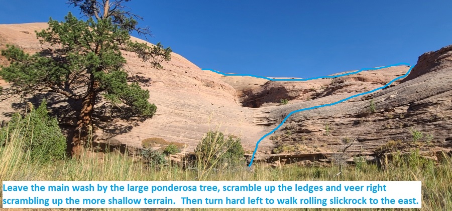
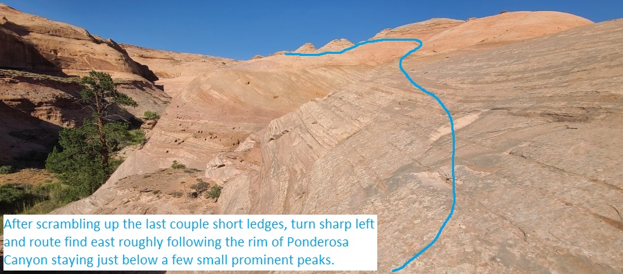
After scrambling up the
last couple short ledges
(Ponderosa02), turn
sharp left and route
find northeast roughly
following the rim of
Ponderosa Canyon staying
just below a few small
prominent peaks.
About 1000 feet farther
is a small saddle / pass
(Ponderosa03) where you
can see a large sandy
area ahead to the east.
Continue east contouring
around to the large
sandy area.
From this large sandy
spot (Ponderosa04)
continue east up steep
slickrock for about 400
feet then contour left
(west) around a small
slickrock hill and over
to the head of the
canyon (yPonderosaTp).
The Canyoneering / Technical Section:
From the top of
Ponderosa Canyon (yPonderosaTp)
walk a short distance to
the top of rap 1.
Rap 1 (dPonderosaR1)
anchored using a bush /
small tree about 70 feet
back then drops another
150 feet down a series
of drops to a large open
section of canyon using
a total of about 220
feet of rope. Some
portions of the rappel
are downclimable and
some are not. After the
first 20 feet is a
pothole, which can hold
water, that tall people
can bridge / stem over
then assist others over.
The final 50ish feet are
vertical and partially
free hanging.
Note:
To keep from carrying a
long rope, we used a 70
foot rope from the
anchor to the top of the
drop then tied on a 150
foot rope for the
remainder of the rappel.
Optionally you could not
use a pull cord at all
and ask a friend to stay
at the top, release the
rope when everyone else
is down then rim walk
the LDC (east) side of
the canyon and scramble
down into the canyon
below rap 1.
Shortly after rap 1 is
the start of
(Ponderosa05) the 400
foot long final slot
with a few easy
downclimbs of about 8
feet each, a short
section of easy
galumphing and a final
drop of about 6 feet.
The final drop can be
jumped to the side to
avoid water at the
bottom (yPonderosaBt).
The Exit:
From the
end of the final slot (yPonderosaBt)
walk wide heavily
vegetated wash about
0.25 miles back to the
road (pkPonderosa).
There are some use
trails that will help
avoid some of the
vegetation.
Downloadable GPX files
available at
BG-Gear Store
(easier than manual entry and a great way to support
Bluugnome).
Waypoint naming convention and map symbol information can be found on the Glossary page.
Elevations are approximate.
BEFORE
manually entering coordinates set your system to WGS84 datum and Lat/Lon hddd.ddddd° coordinate format.
Inconsistent datum's and coordinate formats will result in location errors.
Click to show / expand the list of waypoints below........
| Ponderosa (1) - Approach |
- pkPonderosa
Lat/Lon (WGS84): N 38.01270
W -110.52775
Elev: 4,420 Feet
Park along side the road where room allows near the bottom of Ponderosa Canyon. There is no obvious parking spot. Park anywhere room allows.
To go to Ponderosa Canyon walk east into Ponderosa Canyon a little over 700 feet to a very tall large Ponderosa tree.
- Ponderosa01
Lat/Lon (WGS84): N 38.01290
W -110.52476
Elev: NaN Feet
Ledges going up the south side next to a large ponderosa tree. To go to the top of Ponderosa Canyon scramble up the ledges, veer right (southwest) and scramble up the more shallow terrain.
- Ponderosa02
Lat/Lon (WGS84): N 38.01239
W -110.52495
Elev: NaN Feet
After scrambling up the last couple short ledges, turn sharp left and route find northeast roughly following the rim of Ponderosa Canyon staying just below a few small prominent peaks.
- Ponderosa03
Lat/Lon (WGS84): N 38.01366
W -110.52209
Elev: NaN Feet
Small saddle / pass where you can see a large sandy area ahead to the east. Continue east contouring around to the large sandy area.
- Ponderosa04
Lat/Lon (WGS84): N 38.01444
W -110.52174
Elev: NaN Feet
From this large sandy spot continue east up steep slickrock for about 400 feet then contour left (west) around a small slickrock hill and over to the head of the canyon.
- yPonderosaTp
Lat/Lon (WGS84): N 38.01607
W -110.52190
Elev: 4,710 Feet
Top of Ponderosa Canyon where deep slot forms running down southwest.
|
| Ponderosa (2) - Canyon and Exit |
- yPonderosaTp
Lat/Lon (WGS84): N 38.01607
W -110.52190
Elev: 4,710 Feet
Top of Ponderosa Canyon where deep slot forms running down southwest.
- dPonderosaR1
Lat/Lon (WGS84): N 38.01598
W -110.52191
Elev: NaN Feet
Rap 1 - Ponderosa Canyon. Anchored using a bush / small tree about 70 feet back then drops another 150 feet down a series of drops to a large open section of canyon using a total of about 220 feet of rope. Some portions of the rappel are downclimable and some are not. After the first 20 feet is a pothole, which can hold water, that tall people can bridge / stem over then assist others over. The final 50ish feet are vertical and partially free hanging.
Note: To keep from hauling a long rope, we used a 70 foot rope extended from the anchor to the top of the drop then tied a 150 foot rope to the 70 foot rope to rappel on. Keep in mind you will still need a pull cord of at least 220 feet.
Optionally you could not use a pull cord at all and ask a friend to stay at the top, release the rope when everyone else is down then rim walk the LDC (east) side of the canyon and scramble down into the canyon below rap 1.
- Ponderosa05
Lat/Lon (WGS84): N 38.01497
W -110.52236
Elev: NaN Feet
Start of the 400 foot long final slot with a few easy downclimbs of about 8 feet each, a short section of easy galumphing and a final drop of about 6 feet. The final drop can be jumped to the side to avoid water at the bottom .
- yPonderosaBt
Lat/Lon (WGS84): N 38.01405
W -110.52341
Elev: 4,480 Feet
Bottom of Ponderosa Canyon. Walk wide heavily vegetated wash about 0.25 miles back to the road. There are some use trails that will help avoid some of the vegetation.
- pkPonderosa
Lat/Lon (WGS84): N 38.01270
W -110.52775
Elev: 4,420 Feet
Park along side the road where room allows near the bottom of Ponderosa Canyon. There is no obvious parking spot. Park anywhere room allows.
To go to Ponderosa Canyon walk east into Ponderosa Canyon a little over 700 feet to a very tall large Ponderosa tree.
|