Canyoneering Route Description
Bushwax Canyon - 3A I
North Wash, Utah.
10-15-18, 4 people, 1 Day (Travel time in route 2 hours)

Time Required - 1.5 to 3 hours
Distance - 1 miles Total, 450 feet Technical
Rappels - 0 to 1 Rappels, Longest Rappel
25 feet. Depending on skill level the one drop of 25 feet
can be downclimbed.
Elevation Range - 43901 - 4650 Feet
Shuttle Required - No Vehicle -
Passenger
Permit Required - No
Rappelling and anchor gear, 20 feet of webbing incase an anchor
needs to be set and a 60 foot rope incase someone needs help or
decides a rappel is needed. Those comfortable with downclimbs
in a skinny crack will not need rope.
Bushwax is a short canyon that will take most parties a
couple hours and is totally worth the visit. It is surprising how fun and
pretty this short slot is. The canyon is short but offers narrow
undulating walls where you will need to stem and galumph a few feet up
feeling like you are in a much longer more committed canyon, but only for a
brief time in this 450 foot long slot.
Depending on skill level of the group no ropes will be
needed, however a 60 foot-ish piece of webbing or rope should be on hand in
the event someone wants an assist with a downclimb. One drop of about 25
feet is a downclimb in a skinny crack and those comfortable with this style
of downclimb can provide a meat anchor for those who prefer a rope.
Just after the last drop in the canyon is a lot of
thick vegetation to find your way through. By paying attention to use trails
it is possible to find an easy way through but it is also easy to get forced
into some bushwhacking if your take a wrong turn.
Warning:
The stemming movement
through Bushwax
Canyon is more challenging than the typical North Wash area canyon.
Bushwax Canyon is short but not recommended for a group comprised of all
beginner canyoneers. Bushwax Canyon is better suited for those who
have a experience with stemming and are comfortable with stem style
downclimbs at heights up to 25 feet.
Thanks to Matt Williams for sharing info on the canyon.
Matt had this to say when asked about the name and their trip through.....
"Bushwax was named for the bushwhack at the bottom, while keeping with the
Thrax theme. First known D was Schasch, Julie J, and me (Matt Williams) on
4/13/18"
To get to the Trailhead
From the junction of highways 95 and 276 (about 25 miles south
of Hanksville) drive southeast on highway 95 for 3 miles and
park (pkBushwax) on the side of the road near the mouth of
Bushwax Canyon. Bushwax Canyon will be on the north side
of the road. No particular spot to park just find a place
along the shoulder to get off the road.
To visually check that you have the correct canyon you can drive
about 0.3 miles west from Bushwax and look at the canyon there
where you should be able to see a large ponderosa up in the
canyon. Next you can drive about 0.15 miles east from
Bushwax Canyon and see that the canyon there is a wide open wash
where you can see a large bowl shaped cliff for the head of the
canyon. Bushwax Canyon has a lot of vegetation and trees
densely growing in the drainage.
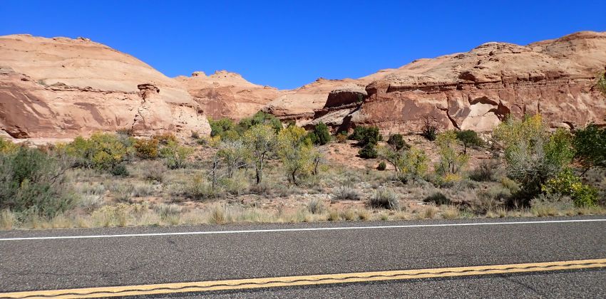 Bushwax viewed from the road.
To leave the Exit Vehicle / Escape Pod
No exit vehicle is needed. This is done as a loop route.
GPS coordinate information listed at the bottom. For information about waypoint naming and map symbols, refer to the
Glossary page.

Click the links for maps of the route.
Map of the entire route.
The Approach:
From the road (pkBushwax)
walk north from the road
up the wash into Bushwax
Canyon.
About 425 feet from the
road start up a sand
slope (Bushwax01) on the
RUC (east) side of the
drainage.
In about 175 feet when
route the gets closer to
the cliff (Bushwax02) on
the right (east) side,
follow use trails going
up canyon and slowly
going up closer to the
cliff base.
About 175 feet farther
just before getting to a
bowl like indent in the
cliff side, turn hard
right and start walking
up (Bushwax03) a ramp
and ledge system up the
cliff side south back
toward the road.
A little over 200 feet
up the ledge and ramp
system is the top of a
minor ravine
(Bushwax04). Turn hard
left and start route
finding your way north
roughly following the
canyon in large rolling
slickrock.
About 375 feet farther
the route crosses over a
minor drainage
(Bushwax05) then up
moderately steep
slickrock continuing
north. Route find north
up along more rolling
slickrock.
About 370 feet farther
is a small sand filled
drainage (Bushwax06) to
walk up continuing
north.
About 220 feet farther
is a small saddle
(Bushwax07) where you
gain views over the top
of Bushwax Canyon.
About 260 feet farther
is the head of Bushwax
Canyon (yBushwaxTp).
The Canyoneering / Technical Section:
At the head of
Bushwax Canyon (yBushwaxTp)
you can cross the canyon
between two potholes.
The second pothole is
very large and may be a
partner assist out of in
some conditions with a
drop of about 15 feet
just after. This can
make a fun practice area
for pothole stuff if
desired. These potholes
and the drop are easily
bypassed by walking the
RDC (west) rim about 250
feet over to a shallow
side drainage to walk /
scramble down to the
canyon floor.
From the top of the RDC
side ravine (Bushwax08)
scramble down into Bush
Wax Canyon on the RDC
side.
Once at the bottom of
the side drainage
(Bushwax09) the canyon
gets narrow where
galumphing is required.
The next 100 feet of
canyon has a silo like
feature where tall
people can stem over and
short people will need
to downclimb into it
about 6 to 8 feet,
followed by a wide
section that most people
can galumph through at
about 10 feet off the
deck followed by a wide
gapping feature that is
easy to stem galumph
down about 8 feet then
back up about 5 feet
where a spicy downclimb
is found on the other
side.
The spicy downclimb
(Bushwax10) of about 25
feet is down a vertical
crack that looks
intimidating from the
top but has good
features to control the
descent. Some may prefer
to rappel this drop
using a meat anchor
provided by others or an
anchor could be set
using one of the pockets
in the canyon wall a
significant distance
back.
After the spicy
downclimb (Bushwax11)
the next 200 feet of
canyon starts with a
gently sloped long
winding and well
featured downclimb that
feels more like a
playground than a
canyon. Followed
by short horizontal
section leading to a
sideways slanted slide
down of about 15 feet to
a small pothole that
most people will be able
to just hop over.
Followed by a section of
galumphing to where the
walls widen out just
before the last drop.
The the walls widen out
a bit (Bushwax12)
with easy travel over to
the final drop at the
end of the canyon.
The final drop (yBushwaxBt)
in the canyon is a
partner assistable
downclimb of about 8
feet down a slightly
sloped wall followed by
an easy scramble down to
the wash below.
The Exit:
From the
end of the canyon
(yBushwaxBt) route find
your way down the wash
navigating sections of
thick vegetation and
intermittent use trails
back to the road.
Downloadable GPX files
available at
BG-Gear Store
(easier than manual entry and a great way to support
Bluugnome).
Waypoint naming convention and map symbol information can be found on the Glossary page.
Elevations are approximate.
BEFORE
manually entering coordinates set your system to WGS84 datum and Lat/Lon hddd.ddddd° coordinate format.
Inconsistent datum's and coordinate formats will result in location errors.
Click to show / expand the list of waypoints below........
| Bushwax (1) - Entire Route |
- pkBushwax
Lat/Lon (WGS84): N 38.00861
W -110.52214
Elev: 4,390 Feet
Park on side of road to start Bushwax Canyon. No particular spot to park just find a place along the shoulder to get off the road. From the road walk north from the road up the wash into Bushwax Canyon.
- Bushwax01
Lat/Lon (WGS84): N 38.00967
W -110.52146
Elev: NaN Feet
Start up a sand slope on the RUC (east) side of the drainage.
- Bushwax02
Lat/Lon (WGS84): N 38.01014
W -110.52152
Elev: NaN Feet
When the route gets closer to the cliff on the right (east) side, follow use trails going up canyon and slowly going up closer to the cliff base.
- Bushwax03
Lat/Lon (WGS84): N 38.01058
W -110.52127
Elev: NaN Feet
Just before getting to a bowl like indent in the cliff side, turn hard right and start walking up a ramp and ledge system up the cliff side south back toward the road.
- Bushwax04
Lat/Lon (WGS84): N 38.01009
W -110.52084
Elev: NaN Feet
Top of a minor ravine. Turn hard left and start route finding your way north roughly following the canyon in large rolling slickrock.
- Bushwax05
Lat/Lon (WGS84): N 38.01085
W -110.52023
Elev: NaN Feet
Route crosses over a minor drainage then up moderately steep slickrock continuing north. Route find north up along more rolling slickrock.
- Bushwax06
Lat/Lon (WGS84): N 38.01183
W -110.51982
Elev: NaN Feet
Small sand filled drainage to walk up continuing north.
- Bushwax07
Lat/Lon (WGS84): N 38.01237
W -110.52006
Elev: 4,620 Feet
Small saddle where you gain views over the top of Bushwax Canyon.
- yBushwaxTp
Lat/Lon (WGS84): N 38.01307
W -110.52000
Elev: 4,610 Feet
Top of BushWax Canyon where you can cross the canyon between two potholes. The second pothole is very large and may be a partner assist out of in some conditions with a drop of about 15 feet just after. This can make a fun practice area for pothole stuff if desired. These potholes and the drop are easily bypassed by walking the RDC (west) rim about 250 feet over to a shallow side drainage to walk / scramble down to the canyon floor.
- Bushwax08
Lat/Lon (WGS84): N 38.01309
W -110.52081
Elev: 4,650 Feet
Top of a shallow side drainage to walk . Scramble down into Bush Wax Canyon on the RDC side.
- Bushwax09
Lat/Lon (WGS84): N 38.01271
W -110.52034
Elev: NaN Feet
Canyon gets narrow where galumphing is required. The next 100 feet of canyon has a silo like feature where tall people can stem over and short people will need to downclimb into it about 6 to 8 feet, followed by a wide section that most people can galumph through at about 10 feet off the deck followed by a wide gapping feature that is easy to stem galumph down about 8 feet then back up about 5 feet where a spicy downclimb is found on the other side.
- Bushwax10
Lat/Lon (WGS84): N 38.01243
W -110.52044
Elev: NaN Feet
Downclimb of about 25 feet down a vertical crack that looks intimidating from the top but has good features to control the descent. Some may prefer to rappel this drop using a meat anchor provided by others or an anchor could be set using one of the pockets in the canyon wall a significant distance back.
- Bushwax11
Lat/Lon (WGS84): N 38.01238
W -110.52048
Elev: NaN Feet
After the spicy downclimb the next 200 feet of canyon starts with a gently sloped long winding and well featured downclimb that feels more like a playground than a canyon. Followed by short horizontal section leading to a sideways slanted slide down of about 15 feet to a small pothole that most people will be able to just hop over. Followed by a section of galumphing to where the walls widen out just before the last drop.
- Bushwax12
Lat/Lon (WGS84): N 38.01216
W -110.52098
Elev: NaN Feet
Walls widen out a bit with easy travel over to the final drop at the end of the canyon.
- yBushwaxBt
Lat/Lon (WGS84): N 38.01195
W -110.52130
Elev: 4,510 Feet
Bottom of Bush Wax Canyon. The final drop in the canyon is a partner assistable downclimb of about 8 feet down a slightly sloped wall followed by an easy scramble down to the wash below. Route find your way down the wash navigating sections of thick vegetation and intermittent use trails back to the road.
- pkBushwax
Lat/Lon (WGS84): N 38.00861
W -110.52214
Elev: 4,390 Feet
Park on side of road to start Bushwax Canyon. No particular spot to park just find a place along the shoulder to get off the road. From the road walk north from the road up the wash into Bushwax Canyon.
|