Canyoneering Route Description
Neon Canyon - 3B III (IV)
Escalante National Monument, Utah
04-13-13, 10 people, 1 Day (Travel time in route 9 hours)

05-10-14, 5 people, 1 Day (Travel time in route 10.5 hours)
Time Required - 9 to 12 hours
Distance - 10.2 miles Total, 1.1 miles Technical
(using the Fork Chop Entry)
Rappels - 4 Rappels, Longest Rappel 95 feet.
using the Fork Chop entry.
Elevation Range - 5620 - 4560 Feet
Shuttle Required - No Vehicle -
High Clearance
Permit Required - No for day use - Yes for
overnight trips (free permit at trailhead)
Rappelling and anchor gear, Ropes and or pull cords for rappels up
to 95 feet and 80 feet of 1 inch webbing for sling placement. A pot
shot is also recommended. There is a keeper pothole that may
require a potshot if the anchor for the bypass route becomes
damaged. The final keeper pothole is generally considered
impassable using a pot shot but having one on had is a good idea.
Wet suits should be on hand as well. If full, Neon can have
sections close to a half mile long of wading and swimming for the
majority of it. If low it is an easy walk through these sections
where you can see the water line indicating just how far you would
be wading ad swimming. If full the long swims could be very
cold and going without a wet suit (even in warm weather) is not
recommended.
Neon canyon is a long route in a remote feeling area.
Some decide to do the route as a long day trip while others do the route as an
overnight and camp near the mouth of Neon by the Escalante river. Weather,
length of day, fitness level of your team and other factors will be major
factors in planning the logistics for your particular journey.
Neon Canyon has multiple points where you can drop into
the canyon. Depending on where you drop into the canyon and how fast you
hike the long open desert approach / exit your route time can vary widely.
The route has been rated with a time requirement of III or IV with the wide
possible time variance in mind.
The Fork Chop Entry, described here passes the Sport
Entry and the More Fun Entry on the way. Choosing either of the two
earlier entries can shorten the day if desired of if you find you are taking
longer than expected. Optionally you can also travel farther up canyon
before dropping in, to enjoy even more canyon. The Fork Chop Entry
enters the lower 1000 feet of a side fork of Neon (Fork Chop) which is
followed down into the Neon drainage.
Note:
If you find yourself pushed
for time on your visit you can drop into the Sport Entry or More Fun Entry
to save a little time as compared to the Fork Chop entry described here.
Dropping into the More Fun Entry will shave off about 1 mile of travel to
your day or dropping into the Sport Entry will shave off about 1.4 miles
from your day and also skip the first keeper pothole / rap 1.
The final rap drops into what is known as the Golden
Cathedral. If you catch the afternoon sun just right the reflection
off of the water and onto the wall and the next person rappelling down can
be jaw droppingly scenic. Many people hike to the bottom of the Golden
Cathedral to wait for the right moments and photograph this place.
The final rappel can use about 30 feet of webbing if it
needs replacement. Wetsuits are recommended even in hot weather.
The long sections that can be swims when full could be very cold making a
wet suit a necessity.
Warning:
There is poison ivy in the
lower portion of the canyon below the Golden Cathedral. It is not
thick and is easily avoided. But it is also easily overlooked and
accidentally touched.
Warning:
There are a couple
of keeper potholes on this route that can be an issue. This is the reason
for the 3 or 4 difficulty rating. The first keeper can be bypassed by going
up and around the LDC side by scrambling up to the rim and rappelling back
in canyon after the keeper. Entry back in canyon after this first keeper
relies on the use of a bolted anchor. If that anchor becomes damaged, it
may be necessary to play through the keeper making the potshot handy.
The final keeper pothole shortly before the final rappel can be impassable
even with a potshot. A log is sometimes in place allowing escape from
the pothole. And sometimes the pothole is full of water allowing one
to simply swim over it. A potshot may help a little but in itself will
not allow escape in since the down canyon side of the pothole is a sand
slope slanting back toward the pothole. By stacking people and using a
potshot may be enough to get out. Depending on water level this can be
a very difficult pothole to escape.
It is highly recommended to check with
canyoneering forums or fellow canyoneers to find out about recent conditions
of the final pothole prior to your trip.
There is an escape route just up canyon of a
short rappel up canyon of the final keeper. It is recommended to keep
at least one person at the top of the short rappel until someone is safely
across the final keeper. Once someone is safely across, someone can
walk back up canyon and have the last person rappel down. If the
keeper is found impassable, the person left behind at the short rappel can
assist everyone back up to go to the escape route.
I have not tried the escape route and have no
detailed information on the route. I have noted where the Moki steps
are to begin the escape route on the map and CPS coordinates.
To get to the Trailhead
From the city of Escalante drive about 4 miles southeast on Hwy
12 to the turn off for Hole-In-The-Rock road on the right (extHoleInRock).
The Hole-In-The-Rock road is dirt. The condition of the road
varies
a lot with recent rains and road maintenance. High clearance
may be needed in extreme cases but most of the time passenger
cars will be fine for the first 30 or 40 miles on Hole in the
Rock road.
Travel about 16.5 miles southeast on Hole-In-The-Rock road to the
turn off on the left (east) for the Egypt road (extEgypt).
Turn left and travel down the Egypt road.
The Egypt road is generally well maintained but a few spots may
be difficult with 2WD low clearance vehicles. A vehicle
with high clearance is VERY helpful and 4WD may be useful but
generally not needed.
The first obstacle is about 3.4 miles in where the Egypt road
crosses over Twentyfive Mile Wash (EgyptDP-01). On the
drive in this is generally in good condition as you drop down a
hill into then across the wash. Driving back out can be a
little difficult with a 2WD vehicle since the hill is steep and
a little speed may be required. The rough wash leading to
the hill may make it difficult to get up to speed.
After crossing Twentyfive Mile Wash, continue on the Egypt road
for about 3.2 miles to where the road crosses over the Egypt 1
drainage (pkEgypt1). At this drainage there is what
appears to be a road forking to the left going up the Egypt 1
drainage. Do not turn left here but instead continue along
the well traveled Egypt road.
About 0.7 miles farther the Egypt road crosses the Egypt 1.5
drainage (pkEgypt1.5). If you are not looking for it and
you may not notice passing by this drainage while on the road.
About 0.5 miles farther the Egypt road crosses the Egypt 2
drainage (PkEgypt2). The head of Egypt 2 Canyon can be
seen to the left (east) less than 100 feet away.
Just after crossing this drainage while driving past here is a
rough section where you will need a high clearance vehicle to
navigate through the slickrock in the drainage. A 2WD
vehicle can make it but it may damage the vehicle.
About 650 feet after passing the Egypt 2 drainage is a hill you
will need to drive up (EgyptDP-02). To drive up this hill
high clearance is needed. Low clearance vehicles will have
issues with this spot. 4WD recommended but not absolutely
needed. A 2WD vehicle will need to get a run at this hill
and need to pick just the right line to get up the hill. I
4WD will make it up the hill with ease.
About 1.4 miles farther will be a fork in the road
(extEgypt9420). The fork to the left (north) on the drive
in goes to a road which is the continuation of the Egypt road
and is signed as 9420. The fork to the right (east) on the drive
in goes over to a well used trailhead / parking area for the
area. Turn right at the fork and travel about 0.6 miles to
the end of the road at the trailhead (pkEgypt5). Park here
to begin the route.
To leave the Exit Vehicle / Escape Pod
No exit vehicle is needed. This is done as an out and back
route.
GPS coordinate information listed at the bottom. For information about waypoint naming and map symbols, refer to the
Glossary page.

Click the links for maps of the route.
Map of the drive into the route.
Map of the entire route and approach
down to Escalante River.
Map of the Canyon overview and approach
up from Escalante River.
Map of the technical section.
The Approach:
From parking are
(pkEgypt5) To go out
toward Neon, route find
your way northeast down
the slickrock slopes
then through open
rolling desert aiming
for a sandstone peak
about 3 miles away just
right of a shallow
drainage running through
the desert. The peak is
near the bottom of Neon
and can be seen for most
of the approach hike
down into the Escalante
River so it makes a good
navigation aid but you
will lose sight of it a
few times during the
first part of the hike
in.
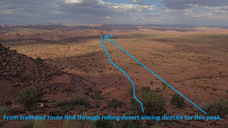 From the trailhead,
route find through
rolling desert aiming
directly for the peak
shown.
From the trailhead,
route find through
rolling desert aiming
directly for the peak
shown.
About 0.43 miles farther
you may run into a sign
(GlenCynBdry10)
indicating the Glen
Canyon National Rec
Boundary. Continue
northeast toward the
peak noted as the
navigation landmark.
About 0.9 miles farther
the route comes to the
top of a slope (Neon01)
leading down to the next
level of rolling desert.
From here you gain good
view of the large
sandstone peak that is
used as your navigation
aid to the northeast.
Continue northeast
toward that peak and the
Escalante River.
About 0.12 miles farther
is top of a shelf
(Neon02) where you can
see down to a large wide
dirt zone just above the
Escalante River. Route
find your way northeast
down to then across the
dirt about 0.33 miles to
where you can scramble
down more slopes to the
Escalante River.
Note:
When getting to
this point on the way in,
if you aimed too far
left (more north) you
will be cliffed out but
can easily walk right
(more east) along the
rim to get to the sloped
dirt you can walk down.
Just before getting down
to the Escalante River
will be a spot on this
final shelf (Neon03)
where you can go down a
kind of steep sand slope
down to the Escalante
River.
Walk about 400 feet
northeast to where you
can cross over the
Escalante River (jNeonBt)
to the mouth of Neon
Canyon on the other
side. Crossing the
river can usually be
done in ankle to knee
deep water.
Warning:
There may be times with
more water flow making
crossing dangerous.
Use good judgment, be
safe and do not cross if
it looks like a bad
idea. The canyon
will be there next time
you decide to try.
After crossing the
Escalante River, walk
about 800 feet northeast
up the Neon drainage to
the bottom (jNeonApr) of
a series of ledges that
you hike / scramble up
on the north side. Make
your way up through the
ledges until you are
near the base of the
upper cliff band to find
use trails contouring up
canyon along the rim.
Note:
There are multiple use
trails that travel up
canyon all at varying
levels along the ledges.
The use trails higher up
are more frequently used
and better defined.
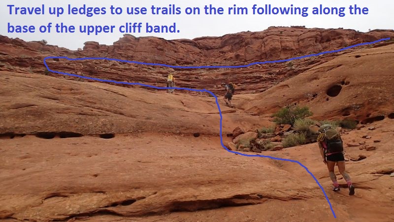 Travel up ledges to
use trails on the rim
following along the base
of the upper cliff band.
Travel up ledges to
use trails on the rim
following along the base
of the upper cliff band.
About 600 feet after
leaving the Neon
drainage (Neon04) you
should now be on good
use trails headed
northeast along the rim.
About 800 feet farther
the trail cross down
over the head of
(Neon05) a slickrock
pour off.
About 0.6 miles farther
the trail contours
around a side drainage
(Neon06Sport). This is
called the Neon "Sport
Entry" where you can
drop down this side
drainage into Neon to
only do the final
section of canyon.
Note:
If doing the Sport
Entry, drop east down
this drainage into Neon.
About 0.3 miles farther
the trail crosses over a
side drainage
(Neon07MorFun). This is
called the Neon "More
Fun Entry" where you can
drop down the ledges in
this side drainage into
Neon to enjoy more
canyon than the Sport
Entry but still have a
shorter day.
Note:
If doing the
More Fun
Entry, drop east down
this drainage into Neon.
About 0.27 miles farther
the trail crosses
(Neon08) over a large
side drainage. To
get to this spot the
trail takes a detour of
about 800 feet to
contour around this
drainage. Cross
over the drainage and
follow the trail as it
contours around back
toward the Neon
drainage.
About 850 feet farther
the trail drops down to
the next lower shelf (
Neon09) and at this
point a side drainage is
between you and the main
Neon drainage. The large
slickrock side drainage
below is Fork Chop and
is used for the Fork
Chop entry to Neon.
Follow the trail about
700 feet northeast along
the rim until you can
see a way where you can
scramble down into Fork
Chop.
When you get to where
you can scramble down
into Fork Chop
(jForkChop1) scramble
about 200 feet down
ledges down into Fork
Chop drainage.
Once down in the Fork
Chop drainage
(jForkChop2) the fun
begins.
The Canyoneering / Technical Section:
From where you get
down into Fork Chop
(jForkChop2), travel
southwest down Fork
Chop.
About 75 feet down
canyon will be two drops
(ForkChop01) of about 6
to 8 feet each where
partner assists to get
down my be helpful.
About 150 feet farther
down Fork Chop is a drop
(FrokChop02) of about 12
feet which can be
partner assisted down a
sloped wall into a waist
deep pothole.
About 350 farther down
Fork Chop is the start
(ForkChop03) of a narrow
section with a few
shallow potholes up to
waist deep. Shortly into
this is a narrow slot
where you can go low and
turn sideways to travel
between two vertical
walls. If you do not
like the tight stuff
below you can stem up
about 20 feet over it
and go about 50 feet
down canyon to drop back
down. After the tight
spot it is about 300
feet of deep narrow
canyon to enjoy with a
few tight spots to turn
sideways through before
Fork Chop ends dropping
you into Neon.
When the Fork Chop slot
drops into Neon Canyon
(yForkChopBt) turn right
and travel southwest
down Neon Canyon.
About 125 feet down
canyon is a drop
(Neon70) of about 10 to
12 feet down a slot into
a long chamber about 80
feet long with waist
deep water. After the
watery chamber is narrow
slot to enjoy walking in
for about 400 more feet
where if wet you could
have up to waist deep
water in a few spots.
About 450 feet farther
in Neon is the
start (Neon71) of a
section of canyon about
0.3 miles long where you
will have a couple of
drops about 5 to 7 feet
each and the rest of the
travel can be walking or
possibly full swim for
most of it if the canyon
is full of water. If
full of water plan on
this entire section
being a wading /
swimming zone in narrow
sculpted walls.
Soon you will come to a
drop (Neon72) of about
12 feet down to more
narrows that can be
waist deep to swimmer
depth continuing down
canyon about 350 feet to
a keeper pothole and rap
1.
The keeper pothole / rap
1 (dNeonR1-Keeper) has 2
options depending on if
you want to cross a
keeper pothole or bypass
it.
Option 1, partner assist
people up a short steep
slope on the LDC side to
a large ledge with a
single bolted hanger and
rap about 35 feet to the
down canyon side of the
keeper pothole to bypass
the keeper.
Option 2, Rappel about
20 feet into the keeper
pothole using a choke
stone anchor and use
potshot or pack toss to cross the
keeper pothole with an
exit upclimb of about 12
feet.
After the
pothole is a corridor
about 400 feet long
where if full of water
you will swim the
majority of it.
About 150 feet after the
water filled corridor is
a side drainage on the
RDC side where the Sport
Entry drops in
(Neon74Sport).
About 100 feet down
canyon of the sport
entry is a set of Moki
steps (Neon75MokiEXT) on
the LDC side going up
out of the drainage.
Note:
The Moki steps go up the
wall on the up canyon
side of an outcropping.
These Moki steps can be
used as an escape from
the canyon if you find
the final keeper pothole
down canyon of here
impassable. Down canyon
of here is a short rap
that may be hard to get
back up. When you
get to this next rap it
is a good idea to leave
one person still at the
top of the rappel to
wait until people down
canyon have determined
the final keeper can be
crossed. If the
keeper is found to be
impassable, the person
at the top of the rappel
can assist others back
up to go back to the
Moki steps.
I have not taken the
Moki step exit route, so
I do do not have
information to give
about where the route
leads. I have been
told it is the way out
if you can not cross the
final keeper pothole.
About 400 feet down
canyon after the walking
section ends (Neon76)
where there is a long
slope of about 35 feet
down into a deep slot.
The slope is just steep
enough to make a
handline a good idea but
not mandatory. Just
after the slope is an
upclimb of about 6 to 8
feet and may require a
partner assist to get
over. Continue down
canyon in another long
corridor that will be
wading and swimming for
about 150 feet down to
rappel 2.
Rap 2 (dNeonR2) is
anchored from log debris
at the top of a log jamb
and drops about 12 feet
to a corridor with more
wading / swimming in
full conditions. This
drop can be upclimbed
with significant effort
if a rope is left at the
drop.
Note:
The final keeper pothole
is about 200 feet down
canyon of here and is
sometimes impassable. It
is a good idea to leave
people at the top of
this rappel and send
others down to check the
keeper. If the keeper is
impassable those at the
top of this rappel can
assist others back up.
About 200 feet down
farther is rap 3 and the
final keeper pothole.
Rap 3 / Final Keeper
(dNeonR3-Keeper)
anchored from arches and
drops about 15 to 30
feet (depending on water
levels) to a keeper
pothole. If the pothole
is sand filled or has a
log placed at the exit,
escape may be easy or
moderately difficult. If
water is low sand is
scoured out and there
are no logs, this keeper
can be impassable with a
sand slope to the down
canyon side making
potshots almost useless.
Sometimes stacking
people can get past this
keeper if water levels
allow. If this
keeper is impassable you
will need to retreat up
canyon to find an exit.
When completely full the
drop to the water is
only a few feet making a
fun jump into the water,
a swim across to a walk
out exit.
Walk a wide sandy
section of canyon for
about 200 feet down to
the final rappel.
Rap 4 (dNeonR4-Golden)
is anchored from a pinch
point between boulders
and drops about 95 feet
through an arch into a
large pool in a hanging
garden alcove area. This
spot called Golden
Cathedral and is well
worth the visit.
Walk about 500 feet down
canyon where the
drainage begins to widen
but still have tall
cliffs on each side
(yNeonBt).
The Exit:
From the
end of the technical
section (yNeonBt) hike
about 0.8 miles to the
end of the Neon drainage
where it dumps into the
Escalante River.
Reverse the approach
route back across the
Escalante (jNeonBt) to
the bottom of the slopes
(Neon03), route find
your way back to the top
of the slopes (Neon02 ).
walk west across rolling
desert up to the high
point of some slopes
(Neon01), continue west
to get back to the
boundary sign
(GlenCynBdry10), then
route find your way west
up the steep slickrock
back to the parking area
(pkEgypt5). See
map.
Downloadable GPX files
available at
BG-Gear Store
(easier than manual entry and a great way to support
Bluugnome).
Waypoint naming convention and map symbol information can be found on the Glossary page.
Elevations are approximate.
BEFORE
manually entering coordinates set your system to WGS84 datum and Lat/Lon hddd.ddddd° coordinate format.
Inconsistent datum's and coordinate formats will result in location errors.
Click to show / expand the list of waypoints below........
| Neon (1) - Drive in |
- extHoleInRock
Lat/Lon (WGS84): N 37.72769
W -111.53143
Elev: NaN Feet
Turn off to Hole-In-The-Rock road from Hwy 12.
- extEgypt
Lat/Lon (WGS84): N 37.54114
W -111.36176
Elev: 5,279 Feet
Turn off to the Egypt Road to the east (left on the drive in on Hole in the Rock road..
- EgyptDP-01
Lat/Lon (WGS84): N 37.56107
W -111.30718
Elev: 4,924 Feet
Egypt Road crosses over Twentyfive Mile Wash. Generally in good condition but may be a little difficult to get back up the hill on the drive back to the Hole in the Rock road. The hill is steep up out of the wash and a 2WD vehicle will need a little speed which is difficult since crossing the wash can be rough.
- pkEgypt1
Lat/Lon (WGS84): N 37.57269
W -111.25778
Elev: 5,270 Feet
Park here to start the Egypt 1 route.
- pkEgypt1.5
Lat/Lon (WGS84): N 37.57647
W -111.24791
Elev: 5,350 Feet
Park here in one of a couple clearings on the right (south) side of the road to start the Egypt 1.5 route.
- PkEgypt2
Lat/Lon (WGS84): N 37.58118
W -111.24291
Elev: NaN Feet
Park here to start down Egypt 2 canyon. Just after crossing this drainage while driving past here is a rough section where you will need a high clearance vehicle to navigate through the slickrock in the drainage.
- EgyptDP-02
Lat/Lon (WGS84): N 37.58278
W -111.24086
Elev: 5,455 Feet
Top of a hill where clearance is needed. 4WD recommended but not absolutely needed. 2wd will need to muscle up with some speed and choose just the right line.
- extEgypt9420
Lat/Lon (WGS84): N 37.59581
W -111.22649
Elev: 5,707 Feet
Fork in the Egypt road. The fork to the left (north) on the drive in goes to a road is the continuation of the Egypt road and is signed as 9420. The fork to the right (east) on the drive in goes over to a well used trailhead / parking area for the area.
- pkEgypt5
Lat/Lon (WGS84): N 37.59306
W -111.21827
Elev: 5,620 Feet
Parking and trailhead for multiple routes in the area. Routes like Neon, Choprock, Egypt 5 and many others.
To go out toward Neon,
Route find your way northeast down the slickrock slopes then through open rolling desert aiming for a sandstone peak about 3 miles away just right of a shallow drainage running through the desert. The peak is near the bottom of Neon and can be seen for most of the approach hike down into the Escalante River so it makes a good navigation aid but you will lose sight of it a few times during the first part of the hike in.
|
| Neon (2) - Approach |
- pkEgypt5
Lat/Lon (WGS84): N 37.59306
W -111.21827
Elev: 5,620 Feet
Parking and trailhead for multiple routes in the area. Routes like Neon, Choprock, Egypt 5 and many others.
To go out toward Neon,
Route find your way northeast down the slickrock slopes then through open rolling desert aiming for a sandstone peak about 3 miles away just right of a shallow drainage running through the desert. The peak is near the bottom of Neon and can be seen for most of the approach hike down into the Escalante River so it makes a good navigation aid but you will lose sight of it a few times during the first part of the hike in.
- GlenCynBdry10
Lat/Lon (WGS84): N 37.59528
W -111.21112
Elev: 5,145 Feet
Sign here indicating Glen Canyon Boundary line.
- Neon01
Lat/Lon (WGS84): N 37.59904
W -111.19484
Elev: NaN Feet
Route comes to the top of a slope leading down to the next level of rolling desert. From here you gain good view of the large sandstone peak that is used as your navigation aid to the northeast. Continue northeast toward that peak and the Escalante River.
- Neon02
Lat/Lon (WGS84): N 37.60535
W -111.17519
Elev: 4,950 Feet
Top of a shelf where you can see down to a large wide dirt zone just above the Escalante River. Route find your way northeast down to then across the dirt about 0.33 miles to where you can scramble down slopes to the Escalante River.
When getting to this point on the way in, if you aimed too far left (more north) you will be cliffed out but can easily walk right (more east) along the rim to get to the sloped dirt you can walk down.
- Neon03
Lat/Lon (WGS84): N 37.60574
W -111.16959
Elev: NaN Feet
A spot on this final shelf where you can go down a kind of steep sand slope down to the Escalante River.
- jNeonBt
Lat/Lon (WGS84): N 37.60639
W -111.16801
Elev: 4,560 Feet
Bottom of the Neon drainage where it meets the Escalante River.
- jNeonApr
Lat/Lon (WGS84): N 37.60815
W -111.16778
Elev: 4,580 Feet
Bottom of a series of ledges that you hike / scramble up on the north side. Make your way up through the ledges until you are near the base of the upper cliff band to find use trails contouring up canyon along the rim.
There are multiple use trails that travel up canyon all at varying levels along the ledges. The use trails higher up are more frequently used and better defined.
- Neon04
Lat/Lon (WGS84): N 37.60971
W -111.16781
Elev: NaN Feet
On good use trails headed northeast along the rim.
- Neon05
Lat/Lon (WGS84): N 37.61163
W -111.16683
Elev: NaN Feet
Trail cross down over the head of a slickrock pour off.
- Neon06Sport
Lat/Lon (WGS84): N 37.61863
W -111.16302
Elev: NaN Feet
Trail contours around a side drainage. This is called the Neon "Sport Entry" where you can drop down this side drainage into Neon to only do the final section of canyon.
- Neon07MorFun
Lat/Lon (WGS84): N 37.62152
W -111.16003
Elev: NaN Feet
Trail crosses over a side drainage. This is called the Neon "More Fun Entry" where you can drop down the ledges in this side drainage into Neon to enjoy more canyon than the Sport Entry but still have a shorter day.
- Neon08
Lat/Lon (WGS84): N 37.62446
W -111.15849
Elev: 5,080 Feet
This is where the trail crosses over a large side drainage. To get to this spot the trail takes a detour of about 800 feet to contour around this drainage. Cross over the drainage and follow the trail as it contours around back toward the Neon drainage.
- Neon09
Lat/Lon (WGS84): N 37.62312
W -111.15717
Elev: NaN Feet
Trail drops down to the next lower shelf here and at this point a side drainage is between you and the main Neon drainage. The large slickrock side drainage below is Fork Chop and is used for the Fork Chop entry to Neon. Follow the trail about 700 feet northeast along the rim until you can see a way where you can scramble down into Fork Chop.
- jForkChop1
Lat/Lon (WGS84): N 37.62412
W -111.15512
Elev: 4,920 Feet
This is where you can see a clear way to scramble about 200 feet down ledges down into Fork Chop drainage.
- jForkChop2
Lat/Lon (WGS84): N 37.62376
W -111.15481
Elev: NaN Feet
Down in the ForkChop drainage. To drop down to Neon Canyon travel southwest down Fork Chop
|
| Neon (3) - The Canyon |
- jForkChop2
Lat/Lon (WGS84): N 37.62376
W -111.15481
Elev: NaN Feet
Down in the ForkChop drainage. To drop down to Neon Canyon travel southwest down Fork Chop
- ForkChop01
Lat/Lon (WGS84): N 37.62358
W -111.15498
Elev: NaN Feet
Two drops of about 6 to 8 feet each where partner assists to get down my be helpful.
- FrokChop02
Lat/Lon (WGS84): N 37.62328
W -111.15533
Elev: NaN Feet
Drop of about 12 feet which can be partner assisted down a sloped wall into a waist deep pothole.
- ForkChop03
Lat/Lon (WGS84): N 37.62274
W -111.15633
Elev: NaN Feet
Start of a narrow section with a few shallow potholes up to waist deep. Shortly into this is a narrow slot where you can go low and turn sideways to travel between two vertical walls. If you do not like the tight stuff below you can stem up about 20 feet over it and go about 50 feet down canyon to drop back down. After the tight spot it is about 300 feet of deep narrow canyon to enjoy with a few tight spots to turn sideways through before Fork Chop ends droppnig you into Neon.
- yForkChopBt
Lat/Lon (WGS84): N 37.62194
W -111.15629
Elev: 4,840 Feet
Bottom of ForkChop where dumps into Neon. Walk about 100 feet down canyon to a drop into a long swiming chamber.
- Neon70
Lat/Lon (WGS84): N 37.62181
W -111.15668
Elev: NaN Feet
Drop of about 10 to 12 feet down a slot into a long chamber about 80 feet long with waist deep water. After the watery chamber is narrow slot to enjoy walking in for about 400 more feet where if wet you could have up to waist deep water in a few spots.
- Neon71
Lat/Lon (WGS84): N 37.62142
W -111.15817
Elev: NaN Feet
Start of a section of canyon about 0.3 miles long where you will have a couple of drops about 5 to 7 feet each and the rest of the travel can be walking or possibly full swim for most of it if the canyon is full of water. If full of water plan on this entire section being a wading / swimming zone in narrow sculpted walls.
- Neon72
Lat/Lon (WGS84): N 37.61930
W -111.16056
Elev: NaN Feet
Drop of about 12 feet down to more narrows that can be waist deep to swimmer depth continuing down canyon about 350 feet to a keeper pothole and rap 1.
- dNeonR1-Keeper
Lat/Lon (WGS84): N 37.61830
W -111.16040
Elev: NaN Feet
Rap 1 - Neon Canyon. There are 2 options depending on if you want to cross a keeper pothole or bypass it.
Option 1, partner assist people up a short steep slope on the LDC side to a large ledge with a single bolted hanger and rap about 35 feet to the down canyon side of the keeper pothole to bypass the keeper.
Option 2, Rappel about 20 feet into the keeper pothole using a choke stone anchor and use potshot or pack toss to cross the keeper pothole with an exit upclimb of about 12 feet.
After the pothole is a corridor about 400 feet long where if full of water you will swim the majority of it.
- Neon74Sport
Lat/Lon (WGS84): N 37.61804
W -111.16208
Elev: NaN Feet
Side drainage on the RDC side where the Sport Entry drops in. This ia almost 150 feet after a water filled corridor.
- Neon75MokiEXT
Lat/Lon (WGS84): N 37.61781
W -111.16214
Elev: 4,720 Feet
Moki steps on the LDC side going up out of the drainage this is about 100 feet after passing a side drainage on the RDC side. The Moki steps go up the wall on the up canyon side of an outcropping.
- Neon76
Lat/Lon (WGS84): N 37.61685
W -111.16195
Elev: NaN Feet
Walking section ends here where there is a long slope of about 35 feet down into a deep slot. The slope is just steep enough to make a handline a good idea but not mandatory. Just after the slope is an upclimb of about 6 to 8 feet and may require a partner assist to get over. Continue down canyon in another long corridor that will be wading and swimming for about 150 feet down to rappel 2
- dNeonR2
Lat/Lon (WGS84): N 37.61643
W -111.16173
Elev: NaN Feet
Rap 2 - Neon Canyon. Anchored from log debris at the top of a log jamb and drops about 12 feet to a corridor with more wading / swimming in full conditions. This drop can be upclimbed with significant effort if a rope is left at the drop.
Of note,the final keeper pothole is about 200 feet down canyon of here and is sometimes impassable. It is a good idea to leave people at the top of this rappel and send others down to check the keeper. If the keeper is impassable those at the top of this rappel can assist others back up.
- dNeonR3-Keeper
Lat/Lon (WGS84): N 37.61592
W -111.16156
Elev: NaN Feet
Rap 3 - Neon Canyon. Anchored from arches and drops about 15 to 30 feet (depending on water levels) to a keeper pothole. If the pothole is sand filled or has a log placed at the exit, escape may be easy or moderately difficult. If water is low sand is scoured out and there are no logs, this keeper can be impassable with a sand slope to the down canyon side making potshots almost useless. Sometimes stacking people can get past this keeper if water levels allow. If this keeper is impassable you will need to retreat up canyon to find an exit. When completely full the drop to the water is only a few feet making a fun jump into the water, a swim across to a walk out exit.
Walk a wide sandy section of canyon for about 200 feet down to the final rappel.
- dNeonR4-Golden
Lat/Lon (WGS84): N 37.61556
W -111.16225
Elev: NaN Feet
Rap 4 - Neon Canyon. Anchored from a pinch point between boulders and drops about 95 feet through an arch into a large pool in a hanging garden alcove area. This spot called Golden Cathedral and is well worth the visit.
- yNeonBt
Lat/Lon (WGS84): N 37.61421
W -111.16290
Elev: 4,660 Feet
Bottom of the technical section after the final rap into the Golden Cathedral. Hike about 0.8 miles to the end of the Neon drainage where it dumps into the Escalante River.
|
| Neon (4) - Exit |
- yNeonBt
Lat/Lon (WGS84): N 37.61421
W -111.16290
Elev: 4,660 Feet
Bottom of the technical section after the final rap into the Golden Cathedral. Hike about 0.8 miles to the end of the Neon drainage where it dumps into the Escalante River.
- jNeonBt
Lat/Lon (WGS84): N 37.60639
W -111.16801
Elev: 4,560 Feet
Bottom of the Neon drainage where it meets the Escalante River.
- Neon03
Lat/Lon (WGS84): N 37.60574
W -111.16959
Elev: NaN Feet
A spot on this final shelf where you can go down a kind of steep sand slope down to the Escalante River.
- Neon02
Lat/Lon (WGS84): N 37.60535
W -111.17519
Elev: 4,950 Feet
Top of a shelf where you can see down to a large wide dirt zone just above the Escalante River. Route find your way northeast down to then across the dirt about 0.33 miles to where you can scramble down slopes to the Escalante River.
When getting to this point on the way in, if you aimed too far left (more north) you will be cliffed out but can easily walk right (more east) along the rim to get to the sloped dirt you can walk down.
- Neon01
Lat/Lon (WGS84): N 37.59904
W -111.19484
Elev: NaN Feet
Route comes to the top of a slope leading down to the next level of rolling desert. From here you gain good view of the large sandstone peak that is used as your navigation aid to the northeast. Continue northeast toward that peak and the Escalante River.
- GlenCynBdry10
Lat/Lon (WGS84): N 37.59528
W -111.21112
Elev: 5,145 Feet
Sign here indicating Glen Canyon Boundary line.
- pkEgypt5
Lat/Lon (WGS84): N 37.59306
W -111.21827
Elev: 5,620 Feet
Parking and trailhead for multiple routes in the area. Routes like Neon, Choprock, Egypt 5 and many others.
To go out toward Neon,
Route find your way northeast down the slickrock slopes then through open rolling desert aiming for a sandstone peak about 3 miles away just right of a shallow drainage running through the desert. The peak is near the bottom of Neon and can be seen for most of the approach hike down into the Escalante River so it makes a good navigation aid but you will lose sight of it a few times during the first part of the hike in.
|