Canyoneering Route Description
Frosted Flakes Canyon - 4A(B) III R+(X-)
Escalante National Monument, Utah.
2019-10-26, 6 people, 1 Day (Travel time in route 8 hours)
 Time includes a couple scenic side trips.
2021-11-14, 3 people, 1 Day
(Travel time in route 7.7 hours)
Time Required - 6 to 8 hours
Distance - 7.4 miles Total, 0.8 miles Technical
Rappels - 3 Rappels, Longest Rappel 140 feet.
Elevation Range - 4155 - 4800 Feet
Shuttle Required - No Vehicle - High Clearance, 4WD if bad road conditions
Permit Required - No
Rappelling and anchor gear, Ropes and or pull cords for rappels up
to 140 feet and 30 feet of 1 inch webbing for sling placement.
Sandtrap and potshots. Wet
suits generally not needed as most water can be avoided. It is
possible to have a couple quick dunks in the upper pothole section
and maybe one in the lower section if recent rains have filled
things up a lot. If you get to the upper pothole section and
see water below, remember you can walk around the 300 foot long
section if desired. We did not use wetsuits.
Frosted Flakes is said by some to be and X canyon while
others feel it is more like R+. I tend to feel this is an R+ canyon as you
are never super lofty high while stemming and the movement is straight forward
with overall easy movement along well featured walls allowing good foot
placement most of the time.
The water rating of A(B) is because there is little
water and it is mostly avoidable. However there are a couple spots
where you may need to take a quick swim or dunk if rains filled things up or
if you are unlucky enough to slip in while trying to avoid water.
Warning:
With that said there is still risk
involved. Do not enter the lower slot of Frosted Flakes unless you are
aware of and willing to take the risks involved with high stemming 30 to 40
feet up. A ground fall would result in sever injury.
The approach route after crossing over Long Branch is
over convoluted but forgiving to travel over rolling slickrock with few
obvious landmarks. A GPS or good map navigation skills helpful here as there
are no obvious landmarks to navigate by.
Frosted Flakes has an upper pothole section about 300
feet long and easily bypassed on the RDC side if desired. After the first
pothole Frosted Flakes is a series of open and narrow sections that is all a
mix of walking and easy galumphing except for one pothole that will require
team work to cross. The last 1000 feet of Frosted Flakes Canyon starts with
easy galumphing which slowly turns to high stemming in the R+ to x- range
with overall easy movement. The stemming section is about 500 feet long with
long sliding downclimbs in semi-darkness just before final rappel. The last
part in semi darkness is one of those places where pictures can not convey
how super cool this this section is and is both eerie and fun at the same
time. The final rappel gets you down into the Big Tony / Sleepy hollow
drainage just below the final rappel of Big Tony.
The upper sections of Frosted Flakes are good to see
one if you like to see the entire scope of a route but the real fun is in
the lower slot. If you just want the fun of the lower slot you can bee
line directly across open rolling slickrock after crossing Long Branch
Canyon on the way up. After crossing Long Branch travel almost due
north to go to the top or travel northwest to go to the top of the final
slot.
I would definitely recommend Frosted Flakes Canyon and
would love to do the lower slot again some time. Fun Place.
A good scenic side trip is to exit the canyon just
before the final section on the RDC side and walk west up and over to the
rim of Big Tony Canyon. Once by the rim you have good views up canyon over
the deep underground section of Big Tony and down canyon over the massive
walled lower non-technical section that you will be walking in after
completing the canyon. This view has more meaning if you have already done
Big Tony Canyon and have a good feel for where you are in relation to the
obstacles below.
To get to the Trailhead
From the city of Escalante drive about 4 miles southeast on Hwy
12 to the turn off for Hole-In-The-Rock road on the right (extHoleInRock). The condition
of the dirt Hole in the Rock road
varies
a lot with recent rains and road maintenance. High clearance
may be needed in extreme cases but most of the time passenger
cars will be fine for the first 30 or 40 miles on Hole in the
Rock road.
Travel about 31.9 miles southeast on
Hole-In-The-Rock road to the turn off for Chimney Rock (exChimneyRk).
Turn left (northeast) onto Chimney Rock Road and drive about 1.9
miles to a sharp left turn in the road (CimneyRk02).
Follow the sharp turn left to drive east. Beyond this
sharp left turn (CimneyRk02) the road has a lot of deep sand.
High clearance / 4WD is recommended.
About 0.7 miles farther is Chimney Rock and a place to park a
few vehicles (ChimneyRock). This is also where the deep
sand ends.
Continue past Chimney Rock for about 1 mile to the end of the
road to park (pkChimCoyoteA)
To leave the Exit Vehicle / Escape Pod
No exit vehicle is needed. This is done as an out and back
route.
GPS coordinate information listed at the bottom. For information about waypoint naming and map symbols, refer to the
Glossary page.

Click the links for maps of the route.
Map of the drive into the route.
Map of the
last part of the drive into the route.
Map of the entire route.
Map of the
approach.
Map of the
last part of approach and technical section.
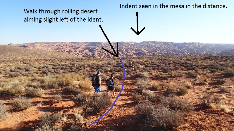
The Approach:
From the parking area (pkChimCoyoteA)
walk northeast toward
the indent seen on the
mesa in the distance.
Aim slight left (west)
of the indent. Walk
through rolling dirt
desert about 0.6 miles
to where the dirt begins
to extend out into
slickrock.
When the dirt begins to
extend out into
slickrock (ChimCoyote11)
continue northeast about
400 feet and starting to
contour down the left
(west) side of the dirt
toward a small short
shallow slot about 400
feet away.
From the top of the
small short shallow slot
(ChimCoyote12) walk
around on the left
(west) side. The route
down into Coyote Gulch
from here will roughly
follow down along the
left (west) side of this
side drainage. Continue
northeast route finding
your way down rolling
slickrock for about 900
feet as you bypass
another slot in this
drainage about 400 feet
long.
After bypassing and
getting to the lower end
(ChimCoyote13) of 400
foot long slot, continue
northeast route finding
your way along rolling
slickrock about 900 feet
to where dirt slopes
lead down into Coyote
Gulch.
From the top of the dirt
slopes (ChimCoyote14)
follow one of many use
trails down into Coyote
Gulch about 200 feet
northeast.
Once down in Coyote
Gulch (jCyoteChimny1)
turn right and walk east
down Coyote Gulch
passing a gate on the
right about 500 feet
down the creek.
Continue down east
Coyote Gulch for about
0.6 miles to the apex of
a sharp turn in Coyote
Gulch (jBigTonyExt).
Leave Coyote Gulch and
go north up the
vegetated dirt slope
toward the Sleepy Hollow
/ Big Tony drainage then
follow use trails over
and down into the Sleepy
Hollow drainage. This
spot is not where the
true Sleepy Hollow water
course meets Coyote
Gulch but it is easier
to go up here instead of
where the Sleepy Hollow
actually meets Coyote
Gulch.
Once in the Sleepy
Hollow drainage,
continue north up the
heavily vegetated creek
following use trails.
About 0.35 miles up
Sleepy Hollow look for a
weakness (jLB-FF-UpTo)
in the cliffs on the
RUC/LDC (east) side.
The weakness is at the
top of a sand bank on
the RUC/LDC (east) side
that leads to slickrock
ramp allowing a scramble
up out of the Sleepy
Hollow / Big Tony
drainage. To go to Long
Branch or Frosted Flakes
canyons, scramble up the
slickrock ramp veering
left roughly following
the rim of the Big Tony
drainage.
About 900 feet after
leaving the Big Tony
drainage, the route gets
to the rim (LongB01 ) of
Long Branch Canyon near
its end. Continue north
east following up along
the rim of long Branch
for about 0.7 miles to
where you can cross over
Long Branch.
When you get to the
shallow spot where you
can cross over Long
Branch (LongB02EE), to
go to the top of Frosted
Flakes Canyon, cross
over Long Branch and aim
very slightly west of
north and travel on easy
rolling slickrock with
no obvious landmarks for
about 0.7 miles to the
top of Frosted Flakes. A
GPS or good map
navigation skills
helpful here as there
are no obvious landmarks
to navigate by.
Note:
To go directly
to the final slot for of
Frosted Flakes Canyon
and not go to the upper
parts of Frosted Flakes,
cross over Long Branch
and aim northwest
and travel on easy
rolling slickrock with
no obvious landmarks for
about 0.45 miles to the
top of the final slot
for Frosted Flakes. A
GPS or good map
navigation skills
helpful here as there
are no obvious landmarks
to navigate by. If
you do this skip down to
the portion of this
description for the
final slot of Frosted
Flakes Canyon.
Once near the head of
Frosted Flakes (yFrostedFlksTp)
walk down gentle slopes
into the drainage.
The Canyoneering / Technical Section:
From the top of
Frosted Flake Canyon (yFrostedFlksTp)
continue southwest down
canyon starting with
shallow V slot with easy
galumphing and walking.
Almost 400 feet down
canyon is the top of rap
1.
Note:
This upper pothole
section is a little over
300 feet long and you
can easily walk around
it on the RDC
(northwest) side if
desired.
Rap 1 (dFrostedR1) is
anchored using a
sandtrap and drops about
30 feet down to a large
pothole that was waist
deep water with a sand
filled bottom when we
were there. This pothole
could be a swimmer and
require a potshot to
exit if sand scours out.
Next is a smaller
pothole with an easier
climb out followed by a
short awkward downclimb
to a 10 foot deep silo
to cross where taller
people will have an
easier time.
Shortly down canyon is a
downclimb of about 8
feet down to a second
gaper silo
(Frosted01Silo) about 10
feet deep. A rope can be
provided for the first
person who can downclimb
about 8 feet and wide
step across the silo.
The last person can do a
pack drag anchor down
into the silo then be
assisted out with rope
from those already
across. Optionally the
strong and brave can
jump over the silo. Just
after this silo is a
drop of about 8 feet
that can be pack dragged
or done as an aggressive
partner assist.
About 100 feet down
canyon is the end of the
first pothole section
(Frosted02EE) where you
can walk into or out of
the canyon on the RDC
side. Continue down
canyon in wide wash.
About 450 feet down
canyon shallow V slot
begins (Frosted03vslot)
with mix of easy galumph
and walk.
About 260 feet into the
V slot is a pothole
(Frosted04PH) to cross
that if sand filled will
have an 8 foot-ish
partner assist downclimb
into and a 6 foot-ish
partner assist upclimb
out of. If sand scours
out this pothole will be
deeper and may require
pack drag anchor to get
into and a potshot to
get out of. Continue
down canyon with easy
galumphing for about 220
feet to where the walls
open again
(Frosted05open) to wide
shallow walking.
About 100 feet down
canyon the walls narrow
again (Frosted06narw)
where travel becomes mix
of walking and easy
galumphing for about 180
feet before walls open
again (Frosted07open).
A little over 500 feet
down canyon walk around
a series of open shallow
potholes (Frosted08).
About 320 feet farther
is the start of
(Frosted09) a short
galumphing section.
About 150 feet farther
is the start of
(yFrostedFlksMd) the
final slot of Frosted
Flakes. Continue
down canyon with a mix
of walking and easy
galumphing. About
300 feet down canyon is
rap 2, the first rap in
the lower final slot.
Note:
If you have time
drop packs here and
leave the canyon on the
RDC (west) side and go
up and over to the rim
of Big Tony about 650
feet away for a great
view down over the final
portions of Big Tony.
Rap 2 (dFrostedR2)
anchored using a tree
about 30 feet up on the
RDC rim and drops about
40 feet using about 70
feet of rope down to a
semi stemmed position
with a pothole just down
canyon that can be
awkward to cross.
Followed by easy
galumphing for about 225
feet.
As the galumphing
section ends the canyon
begins to drop
(Frosted10stem) and you
start stemming higher
off the deck. You will
be stemming 30 to 40
feet off the deck at
times but the movement
is relatively straight
forward with well
featured walls allowing
solid foot placement
most of the time. The
stemming lasts for about
500 feet. The very
last section of the slot
drops into a dark
section with sloped
downclimbs making it
both eerie and fun at
the same time.
Rap 3 (dFrostedR3)
anchored using a
sandtrap and uses about
140 feet of rope with a
vertical drop of about
120 feet. Optionally you
could pendulum while on
rappel over into Big
Tony Canyon just above
its final rap and use
less rope then rappel
the final rap of Big
Tony to get down.
At the bottom of rap 3
is where the Frosted
Flakes Canyon ends where
it dumps into Big Tony
Canyon just below the
final rappel.
The Exit:
From the
bottom of Frosted Flakes
(yFrostedFlksBt) and Big
Tony (yBigTonyBt), walk
the very wet and
vegetated drainage
enjoying the the beauty
for about 1.2 miles to
where Big Tony meets
Coyote Gulch.
Just before reaching the
end you can go up and
over to the right (west)
of a big monolithic rock
(BigTony08) now
traveling up out of the
Big Tony Drainage. As
you get to a large
monolithic rock on the
RDC (west) side of the
drainage travel up to
the right (west) of the
monolith and route find
your way back down into
Coyote Gulch.
About 150 feet farther
you will drop back
down to Coyote Gulch (jBigTonyExt)
a little up stream of
the actual confluence
with the Big Tony
drainage. Turn
right and walk west up
Coyote Gulch about 0.6
miles back to where the
approach route dropped
into Coyote Gulch
(jCyoteChimny1).
Turn left and make your
way southwest up the
dirt slopes and reverse
the approach route back
to the cars.
Downloadable GPX files
available at
BG-Gear Store
(easier than manual entry and a great way to support
Bluugnome).
Waypoint naming convention and map symbol information can be found on the Glossary page.
Elevations are approximate.
BEFORE
manually entering coordinates set your system to WGS84 datum and Lat/Lon hddd.ddddd° coordinate format.
Inconsistent datum's and coordinate formats will result in location errors.
Click to show / expand the list of waypoints below........
| Frosted Flakes (1) - Drive to Trailhead |
- extHoleInRock
Lat/Lon (WGS84): N 37.72769
W -111.53143
Elev: NaN Feet
Turn off to Hole-In-The-Rock road from Hwy 12.
- exHarrisWash
Lat/Lon (WGS84): N 37.60644
W -111.42794
Elev: NaN Feet
Turn off to Harris Wash Road to the east.
- extEgypt
Lat/Lon (WGS84): N 37.54114
W -111.36176
Elev: 5,279 Feet
Turn off to the Egypt Road to the east (left on the drive in on Hole in the Rock road..
- extDryForkTH1
Lat/Lon (WGS84): N 37.46638
W -111.22344
Elev: 4,890 Feet
Turn off of Hole-In-The-Rock road toward Dry Fork trailhead. BLM road 252
This is about 25 miles down Hole in the Rock road.
- exChimneyRk
Lat/Lon (WGS84): N 37.39317
W -111.14345
Elev: 4,831 Feet
Exit to Chimney Rock off off Hole in the Rock road.
This is about 31.9 miles down Hole in the Rock road.
- CimneyRk01
Lat/Lon (WGS84): N 37.39800
W -111.13679
Elev: 4,878 Feet
Exit off to a faint side road to the east.
- CimneyRk02
Lat/Lon (WGS84): N 37.41562
W -111.12539
Elev: 4,735 Feet
Junction in the road. Turn right (east) to drive out to Chimney Rock which gets deep and sandy beyond this point.. Another road contiues north.
- ChimneyRock
Lat/Lon (WGS84): N 37.41085
W -111.11288
Elev: 4,685 Feet
Chimney Rock with lots of area to park and camp.
- pkChimCoyoteA
Lat/Lon (WGS84): N 37.41648
W -111.09846
Elev: 4,720 Feet
Park at end of dirt road here to start the hike to many canyons in this area. Big Tony, DDI, Lower PINTAC, Headless Hen, Raven and others.
To go toward Big Tony, walk northeast toward the indent seen on the mesa in the distance. Aim slight left (west) of the indent. Walk through rolling dirt desert about 0.6 miles to where the dirt begins to extend out into slickrock.
To go toward Raven and Headless Hen, walk northwest on a bearing of about 326 degrees for about 0.65 miles to where the open desert begins to hit slickrock. A GPS or good navigation skills will be helpful here as there are no obvious landmarks.
|
| Frosted Flakes (2) - Approach |
- pkChimCoyoteA
Lat/Lon (WGS84): N 37.41648
W -111.09846
Elev: 4,720 Feet
Park at end of dirt road here to start the hike to many canyons in this area. Big Tony, DDI, Lower PINTAC, Headless Hen, Raven and others.
To go toward Big Tony, walk northeast toward the indent seen on the mesa in the distance. Aim slight left (west) of the indent. Walk through rolling dirt desert about 0.6 miles to where the dirt begins to extend out into slickrock.
To go toward Raven and Headless Hen, walk northwest on a bearing of about 326 degrees for about 0.65 miles to where the open desert begins to hit slickrock. A GPS or good navigation skills will be helpful here as there are no obvious landmarks.
- ChimCoyote11
Lat/Lon (WGS84): N 37.42328
W -111.09231
Elev: NaN Feet
A section of the dirt desert begins to extend out into slickrock. Continue northeast about 400 feet and starting to contour down the left (west) side of the dirt toward a small short shallow slot about 400 feet away.
- ChimCoyote12
Lat/Lon (WGS84): N 37.42413
W -111.09136
Elev: NaN Feet
Top of a small short shallow slot to walk around on the left (west) side. The route down into Coyote Gulch from here will roughly follow down along the left (west) side of this side drainage. Continue northeast route finding your way down rolling slickrock for about 900 feet as you bypass another slot in this drainage about 400 feet long.
- ChimCoyote13
Lat/Lon (WGS84): N 37.42570
W -111.08949
Elev: NaN Feet
Lower end of the slot about 400 feet long in the side drainage, continue northeast route finding your way along rolling slickrock about 900 feet to where dirt slopes lead down into Coyote Gulch.
- ChimCoyote14
Lat/Lon (WGS84): N 37.42687
W -111.08674
Elev: NaN Feet
Top of dirt slopes leading down into Coyote Gulch. Follow one of many use trails down into Coyote Gulch about 200 feet northeast.
- jCyoteChimny1
Lat/Lon (WGS84): N 37.42729
W -111.08622
Elev: 4,190 Feet
Route down from the end of the Chimney Rock road meets Coyote Gluch here.
To go to Big Tony, Frosted Flakes, DDI, Pintac and other canyons east of here, walk east down Coyote Gulch.
About 500 feet down stream fro here is a weakness in the side of the gulch on the LDC side which is used to go to the top of Big Tony. The weakeness is between a left then a right turn in the gulch and right across from a gate.
- jBigTonyApr
Lat/Lon (WGS84): N 37.42724
W -111.08469
Elev: 4,210 Feet
There is a gate here on the RDC side of Coyote Gulch that does not appear to have any function.
To go up to Big Tony, go directly across from the gate to a weakness on the LDC side that allows travel up the side of the gulch to the north just left (west) of what appears to be a side drainage / bowl. Route find your way north then northeast up the slickrock for about 0.25 miles until you get to the top of the rim looking down into lower Sleepy Hollow.
- jBigTonyExt
Lat/Lon (WGS84): N 37.42650
W -111.07838
Elev: 4,155 Feet
Bottom of the Big Tony route at the apex of a sharp turn in Coyote Gulch.
When exiting Big Tony, Frosted Flakes or Long Branch, turn right and walk west up Coyote Gulch.
When approaching Frosted Flakes or Long Branch, leave Coyote Gulch and go north up the vegetated dirt slope toward the Sleepy Hollow / Big Tony drainage then follow use trails over and down into the Sleepy Hollow drainage. This spot is not where the true Sleepy Hollow water course meets Coyote Gulch but it is easier to go up here instead of where the Sleepy Hollow actually meets Coyote Gulch.
- BigTony08
Lat/Lon (WGS84): N 37.42688
W -111.07833
Elev: NaN Feet
Going up and over to the right (west) of a big monolithic rock now traveling up out of the Big Tony Drainage. As you get to a large monolithic rock on the RDC (west) side of the drainage travel up to the right (west) of the monolith and route find your way back down into Coyote Gulch.
There is an inscription at this point dated May 16, 1902 - Ezya Mcinelly.
- jLB-FF-UpTo
Lat/Lon (WGS84): N 37.43075
W -111.08103
Elev: NaN Feet
Top of a sand bank on the RUC/LDC (east) side that leads to slickrock ramp allowing a scramble up out of the Big Tony drainage. To go to Long Branch or Frosted Flakes canyons, scramble up the slickrock ramp veering left roughly following the rim of the Big Tony drainage.
- LongB01
Lat/Lon (WGS84): N 37.43283
W -111.07918
Elev: NaN Feet
About 900 feet after leaving the Big Tony drainage, the route gets to the rim of Long Branch Canyon near its end. Continue north east following up along the rim of long Branch for about 0.7 miles to where you can cross over Long Branch.
- LongB02EE
Lat/Lon (WGS84): N 37.43941
W -111.06969
Elev: 4,560 Feet
Shallow section where you can enter or cross Long Branch Canyon.
To go to the top of Frosted Flakes Canyon, cross over Long Branch here and aim very slightly west of north and travel on easy rolling slickrock with no obvious landmarks for about 0.7 miles to the top of Frosted Flakes. A GPS or good map navigation skills helpful here as there are no obvious landmarks to navigate by.
To go directly to the final slot for of Frosted Flakes Canyon, cross over Long Branch here and aim northwest and travel on easy rolling slickrock with no obvious landmarks for about 0.45 miles to the top of the final slot for Frosted Flakes. A GPS or good map navigation skills helpful here as there are no obvious landmarks to navigate by.
- yFrostedFlksTp
Lat/Lon (WGS84): N 37.44908
W -111.07106
Elev: 4,750 Feet
Top of Frosted Flakes Canyon starting with shallow V slot with easy galumphing and walking.
|
| Frosted Flakes (3) - Canyon |
- yFrostedFlksTp
Lat/Lon (WGS84): N 37.44908
W -111.07106
Elev: 4,750 Feet
Top of Frosted Flakes Canyon starting with shallow V slot with easy galumphing and walking.
- dFrostedR1
Lat/Lon (WGS84): N 37.44838
W -111.07215
Elev: NaN Feet
Rap 1 - Frosted Flakes. Anchored using a sandtrap and drops about 30 feet down to a large pothole that was waist deep water with a sand filled bottom when we were there. This pothole could be a swimmer and require a potshot to exit if sand scours out. Next is a smaller pothole with an easier climb out followed by a short awkward downclimb to a 10 foot deep silo to cross where taller people will have an easier time.
- Frosted01Silo
Lat/Lon (WGS84): N 37.44802
W -111.07240
Elev: 4,623 Feet
Downclimb of about 8 feet down to a second gaper silo about 10 feet deep. A rope can be provided for the first person who can downclimb about 8 feet and wide step across the silo. The last person can do a pack drag anchor down into the silo then be assisted out with rope from those already across. Optionally the strong and brave can jump over the silo. Just after this silo is a drop of about 8 feet that can be pack dragged or done as an aggressive partner assist.
- Frosted02EE
Lat/Lon (WGS84): N 37.44772
W -111.07283
Elev: NaN Feet
End of the first pothole section where you can walk into or out of the canyon on the RDC side. Continue down canyon in wide wash.
- Frosted03vslot
Lat/Lon (WGS84): N 37.44693
W -111.07368
Elev: NaN Feet
Shallow V slot begins with mix of easy galumph and walk.
- Frosted04PH
Lat/Lon (WGS84): N 37.44647
W -111.07437
Elev: NaN Feet
Pothole to cross that if sand filled will have an 8 foot-ish partner assist downclimb into and a 6 foot-ish partner assist upclimb out of. If sand scours out this pothole will be deeper and may require pack drag anchor to get into and a potshot to get out of. Continue down canyon with easy galumphing for about 220 feet to where the walls open again.
- Frosted05open
Lat/Lon (WGS84): N 37.44607
W -111.07500
Elev: 4,543 Feet
Walls open again to wide shallow walking.
- Frosted06narw
Lat/Lon (WGS84): N 37.44597
W -111.07533
Elev: NaN Feet
Walls narrow again where travel becomes mix of walking and easy galumphing for about 180 feet before walls open again.
- Frosted07open
Lat/Lon (WGS84): N 37.44562
W -111.07583
Elev: NaN Feet
- Frosted08
Lat/Lon (WGS84): N 37.44439
W -111.07664
Elev: NaN Feet
Walk around a series of open shallow potholes.
- Frosted09
Lat/Lon (WGS84): N 37.44353
W -111.07628
Elev: 4,580 Feet
Short galumph section.
- yFrostedFlksMd
Lat/Lon (WGS84): N 37.44315
W -111.07635
Elev: 4,570 Feet
Start of the final slot of Frosted Flakes. Continue down canyon with a mix of walking and easy galumphing.
Note: If you have time drop packs here and leave the canyon on the RDC (west) side and go up and over to the rim of Big Tony about 650 feet away for a great view down over the final portions of Big Tony.
- dFrostedR2
Lat/Lon (WGS84): N 37.44245
W -111.07661
Elev: NaN Feet
Rap 2 - Frosted Flakes. Anchored using a tree about 30 feet up on the RDC rim and drops about 40 feet using about 70 feet of rope down to a semi stemmed position with a pothole just down canyon that can be awkward to cross. Followed by easy galumphing for about 225 feet.
- Frosted10stem
Lat/Lon (WGS84): N 37.44207
W -111.07715
Elev: NaN Feet
Canyon begins to drop and you start stemming higher off the deck. You will be stemming 30 to 40 feet off the deck at times but the movement is relatively straight forward with well featured walls allowing solid foot placement most of the time. The stemming lasts for about 500 feet. The very last section of the slot drops into a dark section with sloped downclimbs making it both eerie and fun at the same time.
- dFrostedR3
Lat/Lon (WGS84): N 37.44124
W -111.07860
Elev: NaN Feet
Rap 3 - Frosted Flakes. Anchored using a sandtrap and uses about 140 feet of rope with a vertical drop of about 120 feet. Optionally you could pendulum while on rappel over into Big Tony Canyon just above its final rap and use less rope then rappel the final rap of Big Tony to get down.
- yFrostedFlksBt
Lat/Lon (WGS84): N 37.44121
W -111.07877
Elev: NaN Feet
Bottom of Frosted Flakes Canyon where it dumps into Big Tony Canyon just below the final rappel. Walk the very wet and vegetated drainage enjoying the the beauty for about 1.2 miles to where Big Tony meets Coyote Gulch.
|
| Frosted Flakes (4) - Exit |
- yFrostedFlksBt
Lat/Lon (WGS84): N 37.44121
W -111.07877
Elev: NaN Feet
Bottom of Frosted Flakes Canyon where it dumps into Big Tony Canyon just below the final rappel. Walk the very wet and vegetated drainage enjoying the the beauty for about 1.2 miles to where Big Tony meets Coyote Gulch.
- BigTony08
Lat/Lon (WGS84): N 37.42688
W -111.07833
Elev: NaN Feet
Going up and over to the right (west) of a big monolithic rock now traveling up out of the Big Tony Drainage. As you get to a large monolithic rock on the RDC (west) side of the drainage travel up to the right (west) of the monolith and route find your way back down into Coyote Gulch.
There is an inscription at this point dated May 16, 1902 - Ezya Mcinelly.
- jBigTonyExt
Lat/Lon (WGS84): N 37.42650
W -111.07838
Elev: 4,155 Feet
Bottom of the Big Tony route at the apex of a sharp turn in Coyote Gulch.
When exiting Big Tony, Frosted Flakes or Long Branch, turn right and walk west up Coyote Gulch.
When approaching Frosted Flakes or Long Branch, leave Coyote Gulch and go north up the vegetated dirt slope toward the Sleepy Hollow / Big Tony drainage then follow use trails over and down into the Sleepy Hollow drainage. This spot is not where the true Sleepy Hollow water course meets Coyote Gulch but it is easier to go up here instead of where the Sleepy Hollow actually meets Coyote Gulch.
- jBigTonyApr
Lat/Lon (WGS84): N 37.42724
W -111.08469
Elev: 4,210 Feet
There is a gate here on the RDC side of Coyote Gulch that does not appear to have any function.
To go up to Big Tony, go directly across from the gate to a weakness on the LDC side that allows travel up the side of the gulch to the north just left (west) of what appears to be a side drainage / bowl. Route find your way north then northeast up the slickrock for about 0.25 miles until you get to the top of the rim looking down into lower Sleepy Hollow.
- jCyoteChimny1
Lat/Lon (WGS84): N 37.42729
W -111.08622
Elev: 4,190 Feet
Route down from the end of the Chimney Rock road meets Coyote Gluch here.
To go to Big Tony, Frosted Flakes, DDI, Pintac and other canyons east of here, walk east down Coyote Gulch.
About 500 feet down stream fro here is a weakness in the side of the gulch on the LDC side which is used to go to the top of Big Tony. The weakeness is between a left then a right turn in the gulch and right across from a gate.
- ChimCoyote14
Lat/Lon (WGS84): N 37.42687
W -111.08674
Elev: NaN Feet
Top of dirt slopes leading down into Coyote Gulch. Follow one of many use trails down into Coyote Gulch about 200 feet northeast.
- ChimCoyote13
Lat/Lon (WGS84): N 37.42570
W -111.08949
Elev: NaN Feet
Lower end of the slot about 400 feet long in the side drainage, continue northeast route finding your way along rolling slickrock about 900 feet to where dirt slopes lead down into Coyote Gulch.
- ChimCoyote12
Lat/Lon (WGS84): N 37.42413
W -111.09136
Elev: NaN Feet
Top of a small short shallow slot to walk around on the left (west) side. The route down into Coyote Gulch from here will roughly follow down along the left (west) side of this side drainage. Continue northeast route finding your way down rolling slickrock for about 900 feet as you bypass another slot in this drainage about 400 feet long.
- ChimCoyote11
Lat/Lon (WGS84): N 37.42328
W -111.09231
Elev: NaN Feet
A section of the dirt desert begins to extend out into slickrock. Continue northeast about 400 feet and starting to contour down the left (west) side of the dirt toward a small short shallow slot about 400 feet away.
- pkChimCoyoteA
Lat/Lon (WGS84): N 37.41648
W -111.09846
Elev: 4,720 Feet
Park at end of dirt road here to start the hike to many canyons in this area. Big Tony, DDI, Lower PINTAC, Headless Hen, Raven and others.
To go toward Big Tony, walk northeast toward the indent seen on the mesa in the distance. Aim slight left (west) of the indent. Walk through rolling dirt desert about 0.6 miles to where the dirt begins to extend out into slickrock.
To go toward Raven and Headless Hen, walk northwest on a bearing of about 326 degrees for about 0.65 miles to where the open desert begins to hit slickrock. A GPS or good navigation skills will be helpful here as there are no obvious landmarks.
|