Canyoneering Route Description
Bless Canyon - 4A(B) IV(V)
Capitol Reef National Park, Utah
04-10-21, 3 people, 1 Day (Travel time in route 14.25 hours)

Time Required - 12 to 16 hours
Distance - 15.3 miles Total, 0.5 miles Technical
Rappels - 4 Rappels, Longest Rappel 240 feet.
Elevation Range - 4870 - 5770 Feet
Shuttle Required - Yes 5.8 Miles Vehicle - Passenger
Permit Required - Yes
Rappelling and anchor gear, Ropes and or pull cords for rappels up
to 240 feet and 40 feet of 1 inch webbing for sling placement. Wet
suits not needed but be prepared for a couple spots where you might
swim a few feet.
Bless Canyon, as we did it, is a long day for a short
canyon. If the canyon were not so far from a trailhead, it would be worth a
repeat visit. If you happen to be backpacking in the area, have technical gear
and a little extra time, Bless Canyon is worth a look. If you do not mind long
days with a little technical fun mixed in, this may also be a good fit for you.
Due to the high pay to play ratio, Bless Canyon is not likely to be a canyon
that makes it onto most peoples list.
The route we took was one of the shorter and more
straight forward options allowing a single day route. The route follows old
mining roads along the west side of the Lower Muley strike. The route then
cuts up onto a mesa, down through Bless Canyon then lands down in Lower
Muley Canyon where we then walked up Lower Muley. Part way up Lower
Muley Canyon we followed the cutoff trail up and over into Halls Creek and
over to The Post. The cut off trail is cairned but still has spots
that are difficult to follow, especially in the dark. This route does
require a shuttle of about 6 miles. There are other ways you can travel
through this area which may or may not need a car shuttle. No matter what
route you take to Bless Canyon it will be a long day for a short canyon. Let
your navigations skills go wild and work out a custom route. The hike up
Lower Muley is a scenic treat all in itself.
For the final rappel we extended anchor webbing down to
and slightly over the final lip and used 240 feet of rope. If you do not
extend the webbing you will need more rope. Our longest rope was 150 feet so
we needed to tie ropes together and pass a knot. Due to knot passing we
decided not to ghost the rappel and used webbing to provide a standard
anchor.
Navigation Warning:
Portions of the
Post Cutoff Trail can be difficult to follow in the dark. The route is
usually well cairned but these are harder to see by head light. GPS
may be very useful on this part of the route should you happen to be exiting
in the dark.
Warning:
Rap 1 is over a
constricted section that can stick ropes. Advanced judgment is required to
prevent ropes getting stuck. Bring an extra just in case.
Rating:
The canyon will likely be
an A most of the time but there are a few spots that could be wades or swims
if full so the A(B) rating was given. The total route is long and could be
done as a very long day but some may feel this better suited as an overnight
which is why the length rating of IV(V).
After weekend plans fell apart, we decided to check out
a canyon I had been staring at on Google Earth. While in canyon we found a
bighorn skull in an alcove. Cassy and I placed it upon a rock for display
then used smaller rocks spelling the word bless under it. That fun moment
spawned the name for Bless Canyon.
Cassy used to say bless a lot and it soon became an
expression we would all use. Bless took on many meanings, delightful
surprise, agreement with others, dread of an up coming obstacle, a simple
greeting and many more. Bless became a word we could insert in almost any
situation and we all knew what was meant. It slowly became a bond between a
few of us with Cassy. We would delight when we heard others use the word
knowing the infectious way she used the it was spreading.
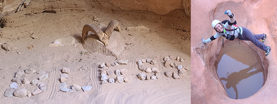 Picture left the bighorn skull and rocks spelling BLESS in Bless
Canyon.
Picture left the bighorn skull and rocks spelling BLESS in Bless
Canyon.
Picture right Cassy in Egypt 3 Canyon. No that pothole is
not in Bless Canyon.
After Cassy died in Mystery Canyon, I felt it would be
fitting to publish this canyon in memory of her. She was one of those people
who had a contagious zest for having fun in the outdoors with friends. She
was one of the few who would join long adventures not caring or asking if
the route would be good or bad. She just wanted to have fun with friends in
the outdoors. Over the last couple years Cassy had secured a spot in our
lives which felt like she would be an epic adventure partner for life!
Unfortunately that did not happen and she will be missed forever by myself
and the many other lives she touched. I have one word for you Cassy
......... BLESS!
To get to the Trailhead
From the town of Boulder Utah, leave highway 12 and follow the
Burr trail for 36 miles until you reach the bottom of the Burr
Trail switchbacks at a Y intersection where the Notom Road meets
the Burr Trail (extBurrTrl). At this Y intersection, the
Notom Road joins in from the northish and the Burr Trail
continues to the southish. Turn right and drive southish
cstill following the Burr Trailrail 2.4 miles to the turn off
for Lower Muley Twist and Headquarters Canyon (exLwrMuleyTwis).
Turn right and follow the side road 0.5 miles south to a large
parking area by a corral and pit toilets (tPostCutoffTH).
To leave the Exit Vehicle / Escape Pod
From the parking area (tPostCutoffTH) drive 0.5 miles back to
the Burr Trail (exLwrMuleyTwist), turn left and drive 2.4 miles
back to the Y intersection with the Notom Road (extBurrTrl),
turn left to drive Burr Trail Switchbacks. From the top of
the switchbacks continue east for about 0.5 miles to a small
unsigned side road on the left (south) and turn onto the side
road (exBlessStart). This turn off is about 0.6 miles east
of the Upper Muley Twist road turn off. After turning onto
the unsigned road follow it southish about 0.4 miles to a
parking area (pkBless) just past some corrals.
GPS coordinate information listed at the bottom. For information about waypoint naming and map symbols, refer to the
Glossary page.

Click the links for maps of the route.
Map of the entire route.
Map of the northern part of the route.
Map of the southern part of the route.
Map of the technical canyon.
Map of The Post Cutoff Trail.
The Approach:
From
the parking spot (pkBless)
walk south roughly
following a wash for
about 1400 feet to where
you should find remnants
where a couple old faded
roads join.
About 0.25 miles farther
(Bless01) a couple of
old faded roads join and
continue south.
About 350 feet farther
(Bless02) is a dirt berm
placed across the road.
Walk around the berm and
continue south following
remnants of an old road.
About 0.3 miles farther
(Bless03)the road
crosses wash and
continues south. The
road on the other side
of the wash goes mostly
un-noticed until you get
a few feet up out of the
wash. Continue south on
the old road.
About 600 feet farther
(Bless04) a smaller road
forks off to the right
(west) going up a slight
hill. Stay on the lower
more major old road and
continue following it
south.
About 0.4 miles farther
(Bless05) the road
crosses a wash then
continues out the other
side to continue south.
About 0.4 miles farther
(Bless06) the old road
crosses wash then
continues south.
About 600 feet farther
(Bless07) the old road
stays up out of the main
wash and crosses over a
small side wash and
continues south.
About 0.4 miles
farther (Bless08) the
old road drops into the
main wash near a fork in
the drainages. Walk
about 60 feet to the
fork then go up the fork
to the left a few feet
to find the old road
going up out of the wash
to continue south.
About 0.4 miles farther
(Bless09) the road
crosses a wash then
contours around to a
dirt hill to go up to a
saddle that can be seen
about 1500 feet to the
south.
About 700 feet farther
(Bless10) is the first
of a few large wash outs
of the road as it climbs
a hill up to the saddle.
About 1000 feet farther
(Bless11) the old road
reaches a saddle in
chocolate red hills.
Follow the road
southeast down the other
side of the saddle.
About 200 feet farther
(Bless12) is a sign
stating STAY OUT OF
MINES. There are a few
mining road wondering
around the hill side
here. For the shortest
route, follow the road
southwest directly down
from the sign.
About 0.24 miles farther
(Bless13) shortly after
crossing a wash the
route gets back on the
more major old road and
continues southeast.
About 750 feet farther
(Bless14) the road
crosses wash then
continues south.
About 1000 feet farther
(Bless15) is a deep wash
out across the old road
to scramble around.
About 750 feet farther
(Bless1) scramble around
a deep wash out across
the road then follow the
road up a gentle hill
veering left to the
southeast.
About 700 feet farther
(Bless17) the road hugs
the hill side and goes
up a little bit steeper.
About 500 feet farther
(Bless18) the road road
crosses deep wash out
with mining debris then
just after is a fork in
the road. Cross the deep
wash then follow up the
fork going down hill to
the right.
About 200 feet farther
(Bless19) the road makes
a jog to the right about
40 feet down a hill then
left again to drop down
a level then continue
south.
About 250 feet farther
(Bless20) as the road
ends route find due
south down across a wash
aiming for a road cut
cutting through a hill
side about 400 feet to
the south. Do not follow
the deep washes down to
the right (west).
About 400 feet farther
(Bless21) is a road-cut
passing through a small
hill as the old road
picks up again. Continue
south following the old
road.
About 500 feet farther
(Bless22) the road goes
around a corner but
still continues south.
About 0.25 miles farther
(Bless23) the road drops
into a shallow wash.
Continue south following
the base of the hill
side on your left and
above the deeper wash on
your right.
About 150 feet farther
(Bless24) Road continues
south contouring below
hill side on the left
and deep wash on the
right.
About 800 feet farther
(Bless25) After weaving
around a bit the road
goes around a bend the
starts down a gentle
hill and continues
weaving around.
About 1100 feet farther
(Bless26) Road crosses a
minor wash and continues
contouring along the
base of the hills.
About 800 feet farther
(Bless27) Road crosses a
wash then contours along
the base of dark
chocolate colored hills
staying up out of the
deeper wash below.
About 300 feet farther
(Bless28) Road fades a
little but still easy to
follow as it contours
along the base of the
chocolate hills.
About 700 feet farther
(Bless29) Road crosses a
wash then begins to wrap
around to the left
following the hill. Do
not follow the road.
Instead walk south
across the shallow wash
then out onto a wide
dirt ridge going south.
Follow down south down
the crest of the ridge.
About 650 feet farther
(Bless30) Large cairn on
the ridge. Continue
south down the ridge
into the drainage below.
About 150 feet farther
(USGS-Bless) USGS survey
marker found while on
route to Bless Canyon.
About 400 feet farther
(Bless31) Short
walkthrough slickrock
slot with one scramble
of about eight feet.
About 1100 feet farther
(Bless32) Confluence of
washes. To go to Bless
Canyon go southwest up a
steep gully running up
the hill side.
About 900 feet farther
(Bless33) Brief top out.
Continue south over
rolling desert for about
800 feet to a hill going
down.
About 700 feet farther
(Bless34) Top of a hill.
Continue south down into
the wash below and to
the base of the final
hill to go up to get to
Bless Canyon.
About 600 feet farther
(Bless35) Base of the
final hill up into Bless
Canyon. There is no one
best way up as you
navigate up the steep
hill and around various
boulders.
About 1000 feet farther
(yBlessTp) Top out of
the saddle at the top of
Bless Canyon. Walk east
down canyon.
The Canyoneering / Technical Section:
From the saddle at
the top of Bless Canyon
(yBlessTp), walk east
down canyon.
About 750 feet farther
(Bless36) Partner
assistable downclimb of
about 8 feet. Optionally
you can use a small
solution pocket on the
RDC side to rappel from.
Just after the downclimb
is a short narrow
section.
About 150 feet farther
(Bless37) Small but deep
alcove on the RDC side
where we found a big
horn skull. Just after
the alcove is a large
boulder debris pile to
scramble down through
into a huge chamber like
area with a house sized
boulder at the bottom of
the boulder pile. This
chamber is very pretty,
don't forget to look
back up canyon a few
times as you travel
down, the up canyon
views are great.
About 400 feet farther
(Bless38) Canyon begins
to slot up and present a
few short downclimbs and
a couple short skinny
spots where you will
need to take your pack
off and turn sideways to
get through.
About 150 feet farther
(dBlessR1) Rap 1 - Bless
Canyon (55 feet rope
travel). Anchored from a
pinch point about 20
feet back and drops
about 35 feet with a
very awkward start over
a tightly pinched pour
over and down to wide
canyon. This rappel is
just under a huge
eroding rock arch. Using
a sandtrap would be
possible but the odds of
getting the trap stuck
at the pinched pour over
would be high. We used a
Flip-It to anchor in the
pinch point.
About 80 feet farther
(Bless39) Very short
downclimb through a
skinny crack then a
short bit of open canyon
before getting to
another longer skinny
section to downclimb
through as it drops
steeply to the next
rappel. The longer
deeper skinny section
has one small pothole
easy to go over then
continues down to a
small pothole shaped
ledge where the next
rappel starts.
About 130 feet farther
(dBlessR2) Rap 2 - Bless
Canyon (45 feet rope
travel). Anchored RDC
from a rock protrusion
about 5 feet back and
drops about 35 feet down
a mostly vertical wall.
A short walk in open
canyon leads to the next
rappel.
About 150 feet farther
(dBlessR3) Rap 3 - Bless
Canyon (65 feet rope
travel). Anchored from a
tree about 20 feet back
and drops down an
awkward squeeze into a
crack dropping about 45
feet to a pool and more
open canyon. The pool
can get up to about
waist deep (we had knee
deep).
About 80 feet farther
(Bless40) Scramble up
onto a ledge on the RDC
side to bypass the first
part of this skinny
crack then at the end of
the ledge scramble down
into the crack and
continue downclimbing
down to another pool
(which was a swimmer for
us). A short walk to
another skinny downclimb
to a skinny pool that
could be a swimmer if
full then the canyon
opens up to an alcove on
the LDC side and pretty
streaked walls.
About 150 feet farther
(Bless41) Huge boulder
debris to go around on
either side. The next
350 feet is mostly easy
walking with two large
pools that can be
avoided with careful
scrambling around the
side ledges before
reaching a narrow slot
about 40 feet long
leading to the final
rappel.
About 400 feet farther
(dBlessR4) Rap 4 - Bless
Canyon (240 feet rope
travel - IF webbing is
extended to just over
the lip - more rope
required if not
extending webbing).
Anchored from a
chokestone about 15 feet
back with webbing
extended to just over
the lip and drops about
230 feet starting with
about 80 feet of free
hang to a small ledge
then becomes free
hanging rappel the rest
of the way.
From
the bottom of the
rappel, boulder-hop down
the hill into the wash
below (yBlessBt).
The Exit:
Once in
the wash (yBlessBt )
walk east down the wash
about 0.4 miles
scrambling around
boulders as needed to
the end of the wash
where it dumps into
Lower Muley Canyon.
Once in Lower Muley
Canyon (jBlessBt) Bottom
of the Bless Canyon
drainage where it dumps
into Lower Muley. To
exit up Lower Muley and
go to The Post, turn
left and walk north up
Lower Muley. To exit
farther down stream in
Halls Creek, turn right
and walk south down
Lower Muley.
About 1.6 miles up the
wash (MuleyAlcove80)
Large undercut alcove
with awesome tiger
striping on it.
About 0.5 miles farther
(MuleyBldrTnl) Huge rock
fall debris blocking
canyon. Cairns lead to a
short tunnel under one
of the house sized
boulders.
About 0.7 miles farther
(MuleyAlcove70) Alcove
undercut so deeply it is
almost cave-like.
About 0.6 miles farther
(MuleyAlcove60) Huge
undercut alcove.
About 1 mile farther (jWomansWorkApr)
Bottom of a large
boulder filled side
canyon / ravine that
could be followed up and
over back to the west
side of the Muley
Strike. Pass this
wide drainage and
continue northish up
Lower Muley Canyon.
About 1.3 miles farther
(tThePostCutofBt) The
Post cutoff trail meets
Lower Muley Twist Canyon
with signs pointing you
to various places.
On
exit out from Bless or
Womans Work Canyons,
leave Lower Muley Twist
Canyon and follow up a
ramp to the north to
follow The Post Cutoff
trail.
About 150 feet up the
ramp (ThePostCutof14)
Once above the ledge
walk northwest up the
wash.
About 350 feet farther
(ThePostCutOff13) Look
for the use trail
leaving the wash and
working its way up the
right (eastish) side
weaving up through rock
layers up into a wide
sandy wash above. This
can be difficult to find
in the dark but a few
cairns have been
helpful.
About 350 feet farther
(ThePostCutOff12) Once
above the rock layers
follow northeast up a
wide sandy wash.
About 1000 feet farther
(ThePostCutOff11)
Continue east following
sandy use trails up the
wide sandy wash.
About 600 feet farther
(ThePostCutOff10)
Continue southeast
following sandy use
trails up the wide sandy
wash.
About 0.33 miles farther
(ThePostCutOff09)
Continue west now on
wide open white
slickrock following teh
occasional cairn.
About 0.25 miles farther
(ThePostCutOff08) Route
find down the ridge
starting down east then
wrapping around north
following the occasional
cairn.
About 500 feet farther
(ThePostCutOff07) Follow
the occasional cairn
leading northeast down
the ridge.
About 300 feet farther
(ThePostCutOff06) Walk
east almost 200 feet
then traverse northish
around to a brief
topout.
About 300 feet farther
(ThePostCutOff05) Follow
a cairned route dropping
down to the northeast
down to a saddle.
About 600 feet farther
(ThePostCutOff04) Route
find northeast to where
the white slickrock
meets a red hill with a
use trail.
About 200 feet farther
(ThePostCutOff03) Follow
a use trail east down
the red hill.
About 1000 feet farther
(ThePostCutOff02) Follow
the well formed use
trail down into Hall
Creek.
About 0.25 miles farther
(ThePostCutOff01) Turn
left and walk north up
Halls creek toward the
Post Cutoff trailhead.
About 400 feet farther (tPostCutoffTH)
is where the entry cars
were parked.
Downloadable GPX files
available at
BG-Gear Store
(easier than manual entry and a great way to support
Bluugnome).
Waypoint naming convention and map symbol information can be found on the Glossary page.
Elevations are approximate.
BEFORE
manually entering coordinates set your system to WGS84 datum and Lat/Lon hddd.ddddd° coordinate format.
Inconsistent datum's and coordinate formats will result in location errors.
Click to show / expand the list of waypoints below........
| Bless Cyn (1) - Drive in to Trailhead |
- extBurrTrl
Lat/Lon (WGS84): N 37.85564
W -111.01272
Elev: 4,983 Feet
Turn off for the Burr Trail road off the water pocket fold road. Both are dirt roads but in dry conditions good for 2 wheel drive.
- exLwrMuleyTwist
Lat/Lon (WGS84): N 37.83296
W -110.98162
Elev: 4,898 Feet
Exit to Lower Muley Twist TH and Headquarters Canyon.
- tPostCutoffTH
Lat/Lon (WGS84): N 37.82629
W -110.97852
Elev: 4,870 Feet
Huge parking area by a large corral for the start of the Lower Muley Twist hiking route. This is the start of The Post cutoff trail which goes up over the Water Pocket Fold then down into Lower Muley Twist.
Walk south about 450 feet to old signs and another sign-in register.
|
| Bless Cyn (2) - Drive in to set exit vehicle |
- tPostCutoffTH
Lat/Lon (WGS84): N 37.82629
W -110.97852
Elev: 4,870 Feet
Huge parking area by a large corral for the start of the Lower Muley Twist hiking route. This is the start of The Post cutoff trail which goes up over the Water Pocket Fold then down into Lower Muley Twist.
Walk south about 450 feet to old signs and another sign-in register.
- exLwrMuleyTwist
Lat/Lon (WGS84): N 37.83296
W -110.98162
Elev: 4,898 Feet
Exit to Lower Muley Twist TH and Headquarters Canyon.
- extBurrTrl
Lat/Lon (WGS84): N 37.85564
W -111.01272
Elev: 4,983 Feet
Turn off for the Burr Trail road off the water pocket fold road. Both are dirt roads but in dry conditions good for 2 wheel drive.
- exBlessStart
Lat/Lon (WGS84): N 37.84971
W -111.03469
Elev: NaN Feet
Turn off onto a side road going past a coral and then to a large turnabout for parking.
- BlessDrv1
Lat/Lon (WGS84): N 37.84836
W -111.03699
Elev: NaN Feet
Road goes by a corral then crosses over a wash.
- pkBless
Lat/Lon (WGS84): N 37.84598
W -111.03757
Elev: 5,710 Feet
Park here to start the route to Bless Canyon. This is a parking area at the far south end of a turnabout.
To go to Bless Canyon, walk south roughly following a wash for about 1400 feet to where you should find remnants where a couple old faded roads join.
|
| Bless Cyn (3) - Approach |
- pkBless
Lat/Lon (WGS84): N 37.84598
W -111.03757
Elev: 5,710 Feet
Park here to start the route to Bless Canyon. This is a parking area at the far south end of a turnabout.
To go to Bless Canyon, walk south roughly following a wash for about 1400 feet to where you should find remnants where a couple old faded roads join.
- Bless01
Lat/Lon (WGS84): N 37.84230
W -111.03781
Elev: NaN Feet
A couple of old faded roads join and continue south.
- Bless02
Lat/Lon (WGS84): N 37.84138
W -111.03764
Elev: NaN Feet
Dirt berm placed across the road. Walk around the berm and continue south following remnants of an old road.
- Bless03
Lat/Lon (WGS84): N 37.83724
W -111.03521
Elev: NaN Feet
Road crosses wash and continues south. The road on the other side of the wash goes mostly un-noticed until you get a few feet up out of the wash. Continue south on the old road.
- Bless04
Lat/Lon (WGS84): N 37.83561
W -111.03481
Elev: NaN Feet
A smaller road forks off to the right (west) going up a slight hill. Stay on the lower more major old road and continue following it south.
- Bless05
Lat/Lon (WGS84): N 37.83148
W -111.03085
Elev: NaN Feet
Road crosses a wash then continues out the other side to continue south.
- Bless06
Lat/Lon (WGS84): N 37.82667
W -111.02934
Elev: NaN Feet
Old road crosses wash then continues south.
- Bless07
Lat/Lon (WGS84): N 37.82493
W -111.03031
Elev: NaN Feet
Old road stays up out of the main wash and crosses over a small side wash and continues south.
- Bless08
Lat/Lon (WGS84): N 37.81941
W -111.03145
Elev: NaN Feet
Old road drops into the main wash near a fork in the drainages. Walk about 60 feet to the fork then go up the fork to the left a few feet to find the old road going up out of the wash to continue south.
- Bless09
Lat/Lon (WGS84): N 37.81424
W -111.03341
Elev: NaN Feet
Road crosses a wash then contours around to a dirt hill to go up to a saddle that can be seen about 1500 feet to the south.
- Bless10
Lat/Lon (WGS84): N 37.81244
W -111.03358
Elev: NaN Feet
First of a few large wash outs of the road as it climbs a hill up to the saddle.
- Bless11
Lat/Lon (WGS84): N 37.81033
W -111.03541
Elev: NaN Feet
Old road reaches a saddle in chocolate red hills. Follow the road southeast down the other side of the saddle.
- Bless12
Lat/Lon (WGS84): N 37.80998
W -111.03480
Elev: NaN Feet
Sign stating STAY OUT OF MINES. There are a few mining road wondering around the hill side here. For the shortest route, follow the road southwest directly down from the sign.
- Bless13
Lat/Lon (WGS84): N 37.80812
W -111.03123
Elev: NaN Feet
Shortly after crossing a wash the route gets back on the more major old road and continues southeast.
- Bless14
Lat/Lon (WGS84): N 37.80730
W -111.02867
Elev: NaN Feet
Road crosses wash then continues south.
- Bless15
Lat/Lon (WGS84): N 37.80447
W -111.02683
Elev: NaN Feet
Deep wash out across the old road to scramble around.
- Bless16
Lat/Lon (WGS84): N 37.80247
W -111.02588
Elev: NaN Feet
Scramble around a deep wash out across the road then follow the road up a gentle hill veering left to the southeast.
- Bless17
Lat/Lon (WGS84): N 37.80110
W -111.02426
Elev: NaN Feet
Road hugs the hill side and goes up a little bit steeper.
- Bless18
Lat/Lon (WGS84): N 37.80058
W -111.02300
Elev: NaN Feet
Road road crosses deep wash out with mining debris then just after is a fork in the road. Cross the deep wash then follow up the fork going down hill to the right.
- Bless19
Lat/Lon (WGS84): N 37.80006
W -111.02295
Elev: NaN Feet
The road makes a jog to the right about 40 feet down a hill then left again to drop down a level then continue south.
- Bless20
Lat/Lon (WGS84): N 37.79944
W -111.02322
Elev: NaN Feet
As the road ends route find due south down across a wash aiming for a road cut cutting through a hill side about 400 feet to the south. Do not follow the deep washes down to the right (west).
- Bless21
Lat/Lon (WGS84): N 37.79832
W -111.02356
Elev: NaN Feet
Road-cut passing through a small hill as the old road picks up again. Continue south following the old road.
- Bless22
Lat/Lon (WGS84): N 37.79713
W -111.02358
Elev: NaN Feet
Road goes around a corner but still continues south.
- Bless23
Lat/Lon (WGS84): N 37.79474
W -111.02083
Elev: NaN Feet
Road drops into a shallow wash. Continue south following the base of the hill side on your left and above the deeper wash on your right.
- Bless24
Lat/Lon (WGS84): N 37.79439
W -111.02054
Elev: NaN Feet
Road continues south contouring below hill side on the left and deep wash on the right.
- Bless25
Lat/Lon (WGS84): N 37.79283
W -111.01995
Elev: NaN Feet
After weaving around a bit the road goes around a bend the starts down a gentle hill and continues weaving around.
- Bless26
Lat/Lon (WGS84): N 37.79191
W -111.01733
Elev: NaN Feet
Road crosses a minor wash and continues contouring along the base of the hills.
- Bless27
Lat/Lon (WGS84): N 37.79075
W -111.01551
Elev: NaN Feet
Road crosses a wash then contours along the base of dark chocolate colored hills staying up out of the deeper wash below.
- Bless28
Lat/Lon (WGS84): N 37.79017
W -111.01558
Elev: NaN Feet
Road fades a little but still easy to follow as it contours along the base of the chocolate hills.
- Bless29
Lat/Lon (WGS84): N 37.78897
W -111.01409
Elev: NaN Feet
Road crosses a wash then begins to wrap around to the left following the hill. Do not follow the road. Instead walk south across the shallow wash then out onto a wide dirt ridge going south. Follow down south down the crest of the ridge.
- Bless30
Lat/Lon (WGS84): N 37.78669
W -111.01395
Elev: NaN Feet
Large cairn on the ridge. Continue south down the ridge into the drainnage below.
- USGS-Bless
Lat/Lon (WGS84): N 37.78646
W -111.01344
Elev: NaN Feet
USGS survey marker found while on route to Bless Canyon.
- Bless31
Lat/Lon (WGS84): N 37.78560
W -111.01275
Elev: NaN Feet
Short walkthrough slickrock slot with one scramble of about eight feet.
- Bless32
Lat/Lon (WGS84): N 37.78420
W -111.00932
Elev: NaN Feet
Confluence of washes. To go to Bless Canyon go southwest up a steep gully running up the hill side.
- Bless33
Lat/Lon (WGS84): N 37.78207
W -111.00793
Elev: NaN Feet
Brief top out. Continue south over rolling desert for about 800 feet to a hill going down.
- Bless34
Lat/Lon (WGS84): N 37.78014
W -111.00751
Elev: NaN Feet
Top of a hill. Continue south down into the wash below and to the base of the final hill to go up to get to Bless Canyon.
- Bless35
Lat/Lon (WGS84): N 37.77887
W -111.00689
Elev: NaN Feet
Base of the final hill up into Bless Canyon. There is no one best way up as you navigate up the steep hill and around various boulders.
- yBlessTp
Lat/Lon (WGS84): N 37.77748
W -111.00451
Elev: 5,770 Feet
Top out of the saddle at the top of Bless Canyon. Walk east down canyon.
|
| Bless Cyn (4) - The Canyon |
- yBlessTp
Lat/Lon (WGS84): N 37.77748
W -111.00451
Elev: 5,770 Feet
Top out of the saddle at the top of Bless Canyon. Walk east down canyon.
- Bless36
Lat/Lon (WGS84): N 37.77801
W -111.00207
Elev: NaN Feet
Partner assistable downclimb of about 8 feet. Optionally you can use a small solution pocket on the RDC side to rappel from.
Just after the downclimb is a short narrow section.
- Bless37
Lat/Lon (WGS84): N 37.77795
W -111.00158
Elev: NaN Feet
Small but deep alcove on the RDC side where we found a big horn skull. Just after the alcove is a large boulder debris pile to scramble down through into a huge chamber like area with a house sized boulder at the bottom of the boulder pile. This chamber is very pretty, don't forget to look back up canyon a few times as you travel down, the up canyon views are great.
- Bless38
Lat/Lon (WGS84): N 37.77814
W -111.00023
Elev: NaN Feet
Canyon begins to slot up and present a few short downclimbs and a couple short skinny spots where you will need to take your pack off and turn sideways to get through.
- dBlessR1
Lat/Lon (WGS84): N 37.77821
W -110.99969
Elev: NaN Feet
Rap 1 - Bless Canyon (55 feet rope travel). Anchored from a pinch point about 20 feet back and drops about 35 feet with a very awkward start over a tightly pinched pour over and down to wide canyon. This rappel is just under a huge eroding rock arch. Using a sandtrap would be possible but the odds of getting the trap stuck at the pinched pour over would be high. We used a Flip-It to anchor in the pinch point.
- Bless39
Lat/Lon (WGS84): N 37.77833
W -110.99946
Elev: NaN Feet
Very short downclimb through a skinny crack then a short bit of open canyon before getting to another longer skinny section to downclimb through as it drops steeply to the next rappel. The longer deeper skinny section has one small pothole easy to go over then continues down to a small pothole shaped ledge where the next rappel starts.
- dBlessR2
Lat/Lon (WGS84): N 37.77832
W -110.99900
Elev: NaN Feet
Rap 2 - Bless Canyon (45 feet rope travel). Anchored RDC from a rock protrusion about 5 feet back and drops about 35 feet down a mostly vertical wall. A short walk in open canyon leads to the next rappel.
- dBlessR3
Lat/Lon (WGS84): N 37.77825
W -110.99849
Elev: NaN Feet
Rap 3 - Bless Canyon (65 feet rope travel). Anchored from a tree about 20 feet back and drops down an awkward squeeze into a crack dropping about 45 feet to a pool and more open canyon. The pool can get up to about waist deep (we had knee deep).
- Bless40
Lat/Lon (WGS84): N 37.77823
W -110.99823
Elev: NaN Feet
Scramble up onto a ledge on the RDC side to bypass the first part of this skinny crack then at the end of the ledge scramble down into the crack and continue downclimbing down to another pool (which was a swimmer for us). A short walk to another skinny downclimb to a skinny pool that could be a swimmer if full then the canyon opens up to an alcove on the LDC side and pretty streaked walls.
- Bless41
Lat/Lon (WGS84): N 37.77826
W -110.99769
Elev: NaN Feet
Huge boulder debris to go around on either side. The next 350 feet is mostly easy walking with two large pools that can be avoided with careful scrambling around the side ledges before reaching a narrow slot about 40 feet long leading to the final rappel.
- dBlessR4
Lat/Lon (WGS84): N 37.77762
W -110.99658
Elev: NaN Feet
Rap 4 - Bless Canyon (240 feet rope travel - IF webbing is extended to just over the lip - more rope required if not extending webbing). Anchored from a chokestone about 15 feet back with webbing extended to just over the lip and drops about 230 feet starting with about 80 feet of free hang to a small ledge then becomes free hanging rappel the rest of the way.
From the bottom of the rappel, boulder-hop down the hill into the wash below.
- yBlessBt
Lat/Lon (WGS84): N 37.77710
W -110.99636
Elev: 5,110 Feet
Bottom of Bless Canyon at the bottom of the rubble pile after the final rappel. To exit walk east down the wash about 0.4 miles scrambling around boulders as needed to the end of the wash where it dumps into Lower Muley Canyon.
|
| Bless Cyn (5) - Exit |
- yBlessBt
Lat/Lon (WGS84): N 37.77710
W -110.99636
Elev: 5,110 Feet
Bottom of Bless Canyon at the bottom of the rubble pile after the final rappel. To exit walk east down the wash about 0.4 miles scrambling around boulders as needed to the end of the wash where it dumps into Lower Muley Canyon.
- jBlessBt
Lat/Lon (WGS84): N 37.77568
W -110.98927
Elev: 4,870 Feet
Bottom of the Bless Canyon drainage where it dumps into Lower Muley. To exit up Lower Muley and go to The Post, turn left and walk north up Lower Muley. To exit farther down stream in Halls Creek, turn right and walk south down Lower Muley.
- MuleyAlcove80
Lat/Lon (WGS84): N 37.78827
W -110.99398
Elev: NaN Feet
Large undercut alcove with awesome tiger striping on it.
- MuleyBldrTnl
Lat/Lon (WGS84): N 37.79188
W -110.99839
Elev: 5,001 Feet
Huge rock fall debris blocking canyon. Cairns lead to a short tunnel under one of the house sized boulders.
- MuleyAlcove70
Lat/Lon (WGS84): N 37.79882
W -110.99855
Elev: 5,044 Feet
Alcove undercut so deeply it is almost cave-like.
- MuleyAlcove60
Lat/Lon (WGS84): N 37.80281
W -110.99870
Elev: NaN Feet
Huge undercut alcove.
- jWomansWorkApr
Lat/Lon (WGS84): N 37.80999
W -111.00221
Elev: 5,240 Feet
Bottom of a large boulder filled side canyon / ravine. To go to Womans Work Canyon leave Lower Muley Twist and go west up this canyon with some walking and a lot of scrambling up over large boulders.
- tThePostCutofBt
Lat/Lon (WGS84): N 37.81975
W -111.00165
Elev: 5,340 Feet
The Post cutoff trail meets Lower Muley Twist Canyon with signs pointing you to various places.
On approach to Womans Work Canyon, continue south down Lower Muley Twist Canyon.
On exit out from Bless or Womans Work Canyons, leave Lower Muley Twist Canyon and follow up a ramp to the north to follow The Post Cutoff trail.
- ThePostCutof14
Lat/Lon (WGS84): N 37.81989
W -111.00196
Elev: NaN Feet
Large ledge in the wash just above Lower Muley.
Following the Cutoff route from The Post to down into Lower Muley:
Veer left east and walk southeast down a ramp down into Lower Muley Twist Canyon.
Following the Cutoff route from up out of Lower Muley and over to The Post:
Once above the ledge walk northwest up the wash.
- ThePostCutof13
Lat/Lon (WGS84): N 37.82063
W -111.00268
Elev: NaN Feet
Use trail meets wash on the northeast side.
Following the Cutoff route from The Post to down into Lower Muley:
Once down in the wash turn left and follow down the wash toward Lower Muley.
Following the Cutoff route from up out of Lower Muley and over to The Post:
Look for the use trail leaving the wash and working its way up the right (eastish) side weaving up through rock layers up into a wide sandy wash above. This can be difficult to find in the dark but a few cairns have been helpful.
- ThePostCutof12
Lat/Lon (WGS84): N 37.82114
W -111.00259
Elev: NaN Feet
Top of a large drop in a wide sandy wash.
Following the Cutoff route from The Post to down into Lower Muley:
Veer left (south) and follow a use trail that switchbacks down the rock layers down into the drainage below.
Following the Cutoff route from up out of Lower Muley and over to The Post:
Once above the rock layers follow northeast up a wide sandy wash.
- ThePostCutof11
Lat/Lon (WGS84): N 37.82159
W -110.99949
Elev: NaN Feet
Use trails pass by a wooden post.
Following the Cutoff route from The Post to down into Lower Muley:
Continue west following sandy use trails down the wide sandy wash.
Following the Cutoff route from up out of Lower Muley and over to The Post:
Continue east following sandy use trails up the wide sandy wash.
- ThePostCutof10
Lat/Lon (WGS84): N 37.82267
W -110.99822
Elev: NaN Feet
Use trails pass by a wooden post.
Following the Cutoff route from The Post to down into Lower Muley:
Continue west following sandy use trails down the wide sandy wash.
Following the Cutoff route from up out of Lower Muley and over to The Post:
Continue southeast following sandy use trails up the wide sandy wash.
- ThePostCutof09
Lat/Lon (WGS84): N 37.82135
W -110.99318
Elev: 5,470 Feet
White slickrock meets more level dirt desert begins.
Following the Cutoff route from The Post to down into Lower Muley:
Continue westish following one of a few use trails webbing through the sandy area leading down a wide sandy draiange.
Following the Cutoff route from up out of Lower Muley and over to The Post:
Continue west now on wide open white slickrock following teh occasional cairn.
- ThePostCutof08
Lat/Lon (WGS84): N 37.82077
W -110.98899
Elev: NaN Feet
Slickrock ridge.
Following the Cutoff route from The Post to down into Lower Muley:
From the top of the ridge route find west along open white slickrock following the occasional carin.
Following the Cutoff route from up out of Lower Muley and over to The Post:
Route find down the ridge starting down east then wrapping around north following the occasional cairn.
- ThePostCutof07
Lat/Lon (WGS84): N 37.82155
W -110.98903
Elev: NaN Feet
Trail cut into the rock.
Following the Cutoff route from The Post to down into Lower Muley:
Follow west down the cut out for about 80 feet then turn left walking south up a wide shallow gully. About 300 feet up the gully begin to veer right and once again strart up to the west to get up onto the next ridge.
Following the Cutoff route from up out of Lower Muley and over to The Post:
Follow the occasional cairn leading northeast down the ridge.
- ThePostCutof06
Lat/Lon (WGS84): N 37.82206
W -110.98834
Elev: NaN Feet
Base of a small ridge.
Following the Cutoff route from The Post to down into Lower Muley:
Follow west up the ridge.
Following the Cutoff route from up out of Lower Muley and over to The Post:
Walk east almost 200 feet then traverse northish around to a brief topout.
- ThePostCutof05
Lat/Lon (WGS84): N 37.82204
W -110.98754
Elev: NaN Feet
Brief top out.
Following the Cutoff route from The Post to down into Lower Muley:
Veer right and traverse northwest-ish a little over 200 feet to a small ridge running up to the west.
Following the Cutoff route from up out of Lower Muley and over to The Post:
Follow a cairned route dropping down to the northeast down to a saddle.
- ThePostCutof04
Lat/Lon (WGS84): N 37.82275
W -110.98595
Elev: NaN Feet
Saddle.
Following the Cutoff route from The Post to down into Lower Muley:
From this saddle contour left (south) to go around the base of the rock outcropping to then continue southwest following carins to a brief topout.
Following the Cutoff route from up out of Lower Muley and over to The Post:
Route find northeast to where the white slickrock meets a red hill with a use trail.
- ThePostCutof03
Lat/Lon (WGS84): N 37.82328
W -110.98566
Elev: NaN Feet
Trail up the red hill tops out and meets white slickrock.
Following the Cutoff route from The Post to down into Lower Muley:
Continue southwest on white slickrock about 200 feet to a small saddle below a rock outcropping.
Following the Cutoff route from up out of Lower Muley and over to The Post:
Follow a use trail east down the red hill.
- ThePostCutof02
Lat/Lon (WGS84): N 37.82329
W -110.98216
Elev: NaN Feet
Bottom of a dark red hill with a well formed use trail going west up the hill.
Following the Cutoff route from The Post to down into Lower Muley:
Follow a use trail west up the semi steep trail.
Following the Cutoff route from up out of Lower Muley and over to The Post:
Follow the well formed use trail down into Hall Creek.
- ThePostCutof01
Lat/Lon (WGS84): N 37.82512
W -110.97824
Elev: NaN Feet
Kiosk and signage that looks like it used to be an old trailhead.
Following the Cutoff route from The Post to down into Lower Muley:
Turn right and follow a well formed use trail west toward the Water Pocket Fold with a few white wooden posts marking the way.
Following the Cutoff route from up out of Lower Muley and over to The Post:
Turn left and walk north up Halls creek toward the Post Cutoff trailhead.
- tPostCutoffTH
Lat/Lon (WGS84): N 37.82629
W -110.97852
Elev: 4,870 Feet
Huge parking area by a large corral for the start of the Lower Muley Twist hiking route. This is the start of The Post cutoff trail which goes up over the Water Pocket Fold then down into Lower Muley Twist.
Walk south about 450 feet to old signs and another sign-in register.
|